![](/images/other/stat-length.png)
![Excursión Bici de montaña Tinchebray-Bocage - Vente Roulleaux, Saint Jean des Bois, Le Fresne Poret - Photo](https://media.geolcdn.com/t/1900/400/ext.pjpeg?maxdim=2&url=https%3A%2F%2Fstatic1.geolcdn.com%2Fsiteimages%2Fupload%2Ffiles%2F1524743154velo.jpg)
Vente Roulleaux, Saint Jean des Bois, Le Fresne Poret
tracegps
Usuario
![Longitud](/images/other/stat-length.png)
Longitud
22 km
![Altitud máxima](https://static1.geolcdn.com/siteimages/upload/files/1508320355ic_sort_altitude_max_24dp.png)
Altitud máxima
320 m
![Desnivel positivo](https://static1.geolcdn.com/siteimages/upload/files/1508320355ic_sort_den_pos_24dp.png)
Desnivel positivo
390 m
![Km-Effort](/images/other/stat-length.png)
Km-Effort
27 km
![Altitud mínima](https://static1.geolcdn.com/siteimages/upload/files/1508320355ic_sort_altitude_min_24dp.png)
Altitud mínima
173 m
![Desnivel negativo](https://static1.geolcdn.com/siteimages/upload/files/1508320355ic_sort_den_neg_24dp.png)
Desnivel negativo
392 m
![Boucle](https://static1.geolcdn.com/siteimages/upload/files/16400158638029165_repeat_loop_refresh_sync_direction_icon.png)
Boucle
Sí
Fecha de creación :
2014-12-10 00:00:00.0
Última modificación :
2014-12-10 00:00:00.0
![Bici de montaña](https://static1.geolcdn.com/sitytour/trail-icons/202.png)
1h49
Dificultad : Medio
![Escanee este código QR para abrir la excursión en la aplicación SityTrail](https://capi.geolives.com/qq0zvz2zws4bq2lad0pu/sitytour/trails/104889/qr.png?size=200)
Aplicación GPS de excursión GRATIS
A propósito
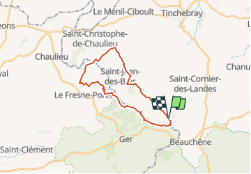
Ruta Bici de montaña de 22 km a descubrir en Normandía, Orne, Tinchebray-Bocage. Esta ruta ha sido propuesta por tracegps.
Descripción
Boucle très sympa qui emprunte de très beaux sentiers. Une partie se fait à cheval entre la Manche et l'Orne. Sentiers bien tracés et assez larges.
Localización
País:
France
Región :
Normandía
Departamento/provincia :
Orne
Municipio :
Tinchebray-Bocage
Localidad:
Beauchêne
Salida:(Dec)
Salida:(UTM)
665885 ; 5395955 (30U) N.
Comentarios
Excursiones cerca
![Excursión Senderismo Tinchebray-Bocage - Chemin de l'Egrenne (n° 9) - Beauchêne - Photo](https://media.geolcdn.com/t/375/260/ext.jpg?maxdim=2&url=https%3A%2F%2Fservices.sitytrail.com%2FGeolivesWS%2FDownloadMedia.ashx%3FTrailID%3D172794%26Media%3D14224_5.jpg)
![Senderismo Senderismo](https://static1.geolcdn.com/sitytour/trail-icons/101.png)
Chemin de l'Egrenne (n° 9) - Beauchêne
Senderismo
Medio
(1)
Tinchebray-Bocage,
Normandía,
Orne,
France
![](/images/other/stat-length.png)
11,2 km | 14,6 km-effort
2h 49min
![](https://static1.geolcdn.com/siteimages/upload/files/16400158638029165_repeat_loop_refresh_sync_direction_icon.png)
Sí
![Excursión A pie Tinchebray-Bocage - Le Ruslé - Photo](https://media.geolcdn.com/t/375/260/d803ed09-bbb7-4724-bfc1-ea340851ab65.jpeg&format=jpg&maxdim=2)
![A pie A pie](https://static1.geolcdn.com/sitytour/trail-icons/100.png)
![Excursión Senderismo Tinchebray-Bocage - Michelot Moulin - Pays de Tinchebray - Photo](https://media.geolcdn.com/t/375/260/ext.jpg?maxdim=2&url=https%3A%2F%2Fservices.sitytrail.com%2FGeolivesWS%2FDownloadMedia.ashx%3FTrailID%3D111669%26Media%3D7907_2.jpg)
![Senderismo Senderismo](https://static1.geolcdn.com/sitytour/trail-icons/101.png)
Michelot Moulin - Pays de Tinchebray
Senderismo
Medio
Tinchebray-Bocage,
Normandía,
Orne,
France
![](/images/other/stat-length.png)
12,4 km | 15,4 km-effort
3h 0min
![](https://static1.geolcdn.com/siteimages/upload/files/16400158638029165_repeat_loop_refresh_sync_direction_icon.png)
Sí
![Excursión A pie Tinchebray-Bocage - Chemin de l'Egrenne - Photo](https://media.geolcdn.com/t/375/260/ext.jpg?maxdim=2&url=https%3A%2F%2Fstatic1.geolcdn.com%2Fsiteimages%2Fupload%2Ffiles%2F1545311037marcheuse_200dpi.jpg)
![A pie A pie](https://static1.geolcdn.com/sitytour/trail-icons/100.png)
Chemin de l'Egrenne
A pie
Fácil
Tinchebray-Bocage,
Normandía,
Orne,
France
![](/images/other/stat-length.png)
10,6 km | 14 km-effort
3h 10min
![](https://static1.geolcdn.com/siteimages/upload/files/16400158638029165_repeat_loop_refresh_sync_direction_icon.png)
Sí
![Excursión Senderismo Tinchebray-Bocage - Le Ruslé (n° 11) - Yvrandes - Photo](https://media.geolcdn.com/t/375/260/ext.jpg?maxdim=2&url=https%3A%2F%2Fstatic1.geolcdn.com%2Fsiteimages%2Fupload%2Ffiles%2F1553511878bg_sport_marche.png)
![Senderismo Senderismo](https://static1.geolcdn.com/sitytour/trail-icons/101.png)
Le Ruslé (n° 11) - Yvrandes
Senderismo
Fácil
Tinchebray-Bocage,
Normandía,
Orne,
France
![](/images/other/stat-length.png)
5,7 km | 7,3 km-effort
1h 30min
![](https://static1.geolcdn.com/siteimages/upload/files/16400158638029165_repeat_loop_refresh_sync_direction_icon.png)
Sí
![Excursión Bici de montaña Tinchebray-Bocage - Vente Roulleaux, Le Tertre, Lonlay l'Abbaye - Photo](https://media.geolcdn.com/t/375/260/ext.jpg?maxdim=2&url=https%3A%2F%2Fstatic1.geolcdn.com%2Fsiteimages%2Fupload%2Ffiles%2F1524743154velo.jpg)
![Bici de montaña Bici de montaña](https://static1.geolcdn.com/sitytour/trail-icons/202.png)
Vente Roulleaux, Le Tertre, Lonlay l'Abbaye
Bici de montaña
Medio
Tinchebray-Bocage,
Normandía,
Orne,
France
![](/images/other/stat-length.png)
25 km | 32 km-effort
1h 55min
![](https://static1.geolcdn.com/siteimages/upload/files/16400158638029165_repeat_loop_refresh_sync_direction_icon.png)
No
![Excursión Bici de montaña Tinchebray-Bocage - Boucle autour de Ger et de ses éoliennes - Photo](https://media.geolcdn.com/t/375/260/ext.jpg?maxdim=2&url=https%3A%2F%2Fstatic1.geolcdn.com%2Fsiteimages%2Fupload%2Ffiles%2F1524743154velo.jpg)
![Bici de montaña Bici de montaña](https://static1.geolcdn.com/sitytour/trail-icons/202.png)
Boucle autour de Ger et de ses éoliennes
Bici de montaña
Fácil
Tinchebray-Bocage,
Normandía,
Orne,
France
![](/images/other/stat-length.png)
19,9 km | 25 km-effort
2h 30min
![](https://static1.geolcdn.com/siteimages/upload/files/16400158638029165_repeat_loop_refresh_sync_direction_icon.png)
Sí
![Excursión Bici de montaña Tinchebray-Bocage - Ger, Saint Jean des Bois, Yvrandes, Les Trois Cheminées - Photo](https://media.geolcdn.com/t/375/260/ext.jpg?maxdim=2&url=https%3A%2F%2Fstatic1.geolcdn.com%2Fsiteimages%2Fupload%2Ffiles%2F1524743154velo.jpg)
![Bici de montaña Bici de montaña](https://static1.geolcdn.com/sitytour/trail-icons/202.png)
Ger, Saint Jean des Bois, Yvrandes, Les Trois Cheminées
Bici de montaña
Medio
Tinchebray-Bocage,
Normandía,
Orne,
France
![](/images/other/stat-length.png)
21 km | 27 km-effort
2h 30min
![](https://static1.geolcdn.com/siteimages/upload/files/16400158638029165_repeat_loop_refresh_sync_direction_icon.png)
Sí
![Excursión Senderismo Tinchebray-Bocage - Petiteboucle à pied - La Vente Roulleau - Photo](https://media.geolcdn.com/t/375/260/ext.jpg?maxdim=2&url=https%3A%2F%2Fstatic1.geolcdn.com%2Fsiteimages%2Fupload%2Ffiles%2F1553511878bg_sport_marche.png)
![Senderismo Senderismo](https://static1.geolcdn.com/sitytour/trail-icons/101.png)
Petiteboucle à pied - La Vente Roulleau
Senderismo
Medio
Tinchebray-Bocage,
Normandía,
Orne,
France
![](/images/other/stat-length.png)
3,1 km | 4,4 km-effort
30min
![](https://static1.geolcdn.com/siteimages/upload/files/16400158638029165_repeat_loop_refresh_sync_direction_icon.png)
Sí