![](/images/other/stat-length.png)
![Excursión Bici de montaña Mirabeau - Grande Traversée des PréAlpes à VTT : Mirabeau - La Jasse - Photo](https://media.geolcdn.com/t/1900/400/ext.pjpeg?maxdim=2&url=https%3A%2F%2Fservices.sitytrail.com%2FGeolivesWS%2FDownloadMedia.ashx%3FTrailID%3D104767%26Media%3D8220_2.jpg)
Grande Traversée des PréAlpes à VTT : Mirabeau - La Jasse
tracegps
Usuario
![Longitud](/images/other/stat-length.png)
![Altitud máxima](https://static1.geolcdn.com/siteimages/upload/files/1508320355ic_sort_altitude_max_24dp.png)
![Desnivel positivo](https://static1.geolcdn.com/siteimages/upload/files/1508320355ic_sort_den_pos_24dp.png)
![Km-Effort](/images/other/stat-length.png)
![Altitud mínima](https://static1.geolcdn.com/siteimages/upload/files/1508320355ic_sort_altitude_min_24dp.png)
![Desnivel negativo](https://static1.geolcdn.com/siteimages/upload/files/1508320355ic_sort_den_neg_24dp.png)
![Boucle](https://static1.geolcdn.com/siteimages/upload/files/16400158638029165_repeat_loop_refresh_sync_direction_icon.png)
![Bici de montaña](https://static1.geolcdn.com/sitytour/trail-icons/202.png)
2h30
Dificultad : Medio
![Escanee este código QR para abrir la excursión en la aplicación SityTrail](https://capi.geolives.com/qq0zvz2zws4bq2lad0pu/sitytour/trails/104767/qr.png?size=200)
Aplicación GPS de excursión GRATIS
A propósito
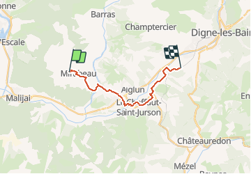
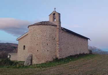
Ruta Bici de montaña de 14,8 km a descubrir en Provenza-Alpes-Costa Azul, Alpes de Alta Provenza, Mirabeau. Esta ruta ha sido propuesta por tracegps.
Descripción
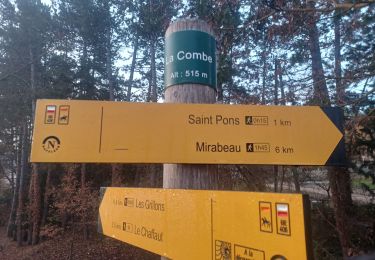
Grande Traversée des Préalpes, les Chemins du Soleil. Parcours officiel labellisé par la Fédération Française de Cyclisme. De Mirabeau, l'itinéraire rejoint la vallée de la Bléone par une descente agréable à travers les pâturages. Vous entrez dans le Pays Dignois. Peu de difficulté, de nombreuses animations jalonnent le parcours (accro branche, baignade...) Consultez toutes les informations sur les hébergements et les services associés sur la fiche du tronçon.
Localización
Comentarios
Excursiones cerca
![Excursión Senderismo L'Escale - Les Balcons de la Durance 11.2.24 - Photo](https://media.geolcdn.com/t/375/260/0c181ea8-d592-4fc1-a24c-1c5ed7f6ced7.jpg&format=jpg&maxdim=2)
![Senderismo Senderismo](https://static1.geolcdn.com/sitytour/trail-icons/101.png)
Senderismo
![](/images/other/stat-length.png)
![](https://static1.geolcdn.com/siteimages/upload/files/16400158638029165_repeat_loop_refresh_sync_direction_icon.png)
![Excursión Senderismo Le Chaffaut-Saint-Jurson - ESPINOUSSE . LES RAGOTS O L S - Photo](https://media.geolcdn.com/t/375/260/be64adbe-0b8d-4834-8b08-174d77c29be7.jpg&format=jpg&maxdim=2)
![Senderismo Senderismo](https://static1.geolcdn.com/sitytour/trail-icons/101.png)
Senderismo
![](/images/other/stat-length.png)
![](https://static1.geolcdn.com/siteimages/upload/files/16400158638029165_repeat_loop_refresh_sync_direction_icon.png)
![Excursión Senderismo L'Escale - L ESCALE . LES BALCONS DE LA DURANCE . O - Photo](https://media.geolcdn.com/t/375/260/3fa23b3f-4fd1-41d6-a6cb-c36da6763f5a.jpg&format=jpg&maxdim=2)
![Senderismo Senderismo](https://static1.geolcdn.com/sitytour/trail-icons/101.png)
Senderismo
![](/images/other/stat-length.png)
![](https://static1.geolcdn.com/siteimages/upload/files/16400158638029165_repeat_loop_refresh_sync_direction_icon.png)
![Excursión Senderismo Mallemoisson - MALLEMOISSON . LES THUMINS . LE CHATEAU . MIRABEAU . CHAPELLE S PHILIPPE . N. EAU - Photo](https://media.geolcdn.com/t/375/260/fa075058-6ed2-4835-9bce-3a241d712d49.jpg&format=jpg&maxdim=2)
![Senderismo Senderismo](https://static1.geolcdn.com/sitytour/trail-icons/101.png)
Senderismo
![](/images/other/stat-length.png)
![](https://static1.geolcdn.com/siteimages/upload/files/16400158638029165_repeat_loop_refresh_sync_direction_icon.png)
![Excursión Senderismo Aiglun - AIGLUN. Le vieil Aiglun , sommet du Puy o l s - Photo](https://media.geolcdn.com/t/375/260/79f9a8c4-2d87-4650-b00f-e4d73efa9932.jpg&format=jpg&maxdim=2)
![Senderismo Senderismo](https://static1.geolcdn.com/sitytour/trail-icons/101.png)
Senderismo
![](/images/other/stat-length.png)
![](https://static1.geolcdn.com/siteimages/upload/files/16400158638029165_repeat_loop_refresh_sync_direction_icon.png)
![Excursión Senderismo L'Escale - L ESCALE , Vierres , la Rouerie , ravin de la pierre taillée, Volonne 0 m s - Photo](https://media.geolcdn.com/t/375/260/beda24b4-9d94-4c54-b5d1-1226c0fcf56b.jpg&format=jpg&maxdim=2)
![Senderismo Senderismo](https://static1.geolcdn.com/sitytour/trail-icons/101.png)
Senderismo
![](/images/other/stat-length.png)
![](https://static1.geolcdn.com/siteimages/upload/files/16400158638029165_repeat_loop_refresh_sync_direction_icon.png)
![Excursión Senderismo Mirabeau - MIRABEAU Ravin de Barbarrine , Bastide Blanche , le Ruth , Col des Penitents , la Colette , o l - Photo](https://media.geolcdn.com/t/375/260/30d4dbc9-7161-414d-8349-8cc15cb6dbbd.jpg&format=jpg&maxdim=2)
![Senderismo Senderismo](https://static1.geolcdn.com/sitytour/trail-icons/101.png)
Senderismo
![](/images/other/stat-length.png)
![](https://static1.geolcdn.com/siteimages/upload/files/16400158638029165_repeat_loop_refresh_sync_direction_icon.png)
![Excursión Senderismo Mirabeau - MALIJAI . CHAPELLE S CHRISTOL . CHAPELLE S PHILIPPE . RAVIN DES SAUVEES N - Photo](https://media.geolcdn.com/t/375/260/2db39e85-2b02-4a81-aa4c-2db148d80f70.jpg&format=jpg&maxdim=2)
![Senderismo Senderismo](https://static1.geolcdn.com/sitytour/trail-icons/101.png)
Senderismo
![](/images/other/stat-length.png)
![](https://static1.geolcdn.com/siteimages/upload/files/16400158638029165_repeat_loop_refresh_sync_direction_icon.png)
![Excursión Senderismo Mallemoisson - MALLEMOISSON . A LA DÉCOUVERTE DE MALLEMOISSON . N - Photo](https://media.geolcdn.com/t/375/260/9bf7e860-0303-464c-9f50-bd1deaa68b13.jpg&format=jpg&maxdim=2)
![Senderismo Senderismo](https://static1.geolcdn.com/sitytour/trail-icons/101.png)
Senderismo
![](/images/other/stat-length.png)
![](https://static1.geolcdn.com/siteimages/upload/files/16400158638029165_repeat_loop_refresh_sync_direction_icon.png)