![](/images/other/stat-length.png)
![Excursión Raquetas de nieve Prayols - Le Picou du Prat d'Albis - Photo](https://media.geolcdn.com/t/1900/400/ext.pjpeg?maxdim=2&url=https%3A%2F%2Fstatic1.geolcdn.com%2Fsiteimages%2Fupload%2Ffiles%2F1524743153raquette.jpg)
Le Picou du Prat d'Albis
tracegps
Usuario
![Longitud](/images/other/stat-length.png)
![Altitud máxima](https://static1.geolcdn.com/siteimages/upload/files/1508320355ic_sort_altitude_max_24dp.png)
![Desnivel positivo](https://static1.geolcdn.com/siteimages/upload/files/1508320355ic_sort_den_pos_24dp.png)
![Km-Effort](/images/other/stat-length.png)
![Altitud mínima](https://static1.geolcdn.com/siteimages/upload/files/1508320355ic_sort_altitude_min_24dp.png)
![Desnivel negativo](https://static1.geolcdn.com/siteimages/upload/files/1508320355ic_sort_den_neg_24dp.png)
![Boucle](https://static1.geolcdn.com/siteimages/upload/files/16400158638029165_repeat_loop_refresh_sync_direction_icon.png)
![Raquetas de nieve](https://static1.geolcdn.com/sitytour/trail-icons/504.png)
5h00
Dificultad : Difícil
![Escanee este código QR para abrir la excursión en la aplicación SityTrail](https://capi.geolives.com/qq0zvz2zws4bq2lad0pu/sitytour/trails/104718/qr.png?size=200)
Aplicación GPS de excursión GRATIS
A propósito
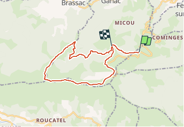
Ruta Raquetas de nieve de 14,9 km a descubrir en Occitania, Ariège, Prayols. Esta ruta ha sido propuesta por tracegps.
Descripción
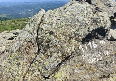
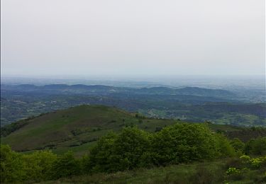
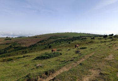
La balade part du Prat d'Albis au sud-ouest de Foix par la D421. En début de saison, la route peut être enneigée. Il sera nécessaire de partir de plus bas. La première partie s'effectue en versant Nord sur une route forestière à l'enneigement tardif. La montée vers le Picou se fait par le Nord. Par beau temps on appréciera le panorama sur les Pyrénées ariégeoises et la vue à 360° permettant d'apercevoir le Vallier, le Fourcat, le Saint Barthelémy, Roquefixade, Montségur... Le retour emprunte en partie le GR Pays du tour de la Barguillère. On peut agrémenter le retour en passant par le Bout de Touron.
Localización
Comentarios
Excursiones cerca
![Excursión Senderismo Ganac - Prat d'Albis Alain Goudou - Photo](https://media.geolcdn.com/t/375/260/e01d843f-f77d-410c-9ffc-0deb7487accd.jpg&format=jpg&maxdim=2)
![Senderismo Senderismo](https://static1.geolcdn.com/sitytour/trail-icons/101.png)
Senderismo
![](/images/other/stat-length.png)
![](https://static1.geolcdn.com/siteimages/upload/files/16400158638029165_repeat_loop_refresh_sync_direction_icon.png)
![Excursión Bici de montaña Ganac - Prat Albis - Verniolle - Photo](https://media.geolcdn.com/t/375/260/ext.jpg?maxdim=2&url=https%3A%2F%2Fservices.sitytrail.com%2FGeolivesWS%2FDownloadMedia.ashx%3FTrailID%3D128789%26Media%3D05b2f854-454a-4b38-ac8f-0c42da59f54b.jpg)
![Bici de montaña Bici de montaña](https://static1.geolcdn.com/sitytour/trail-icons/202.png)
Bici de montaña
![](/images/other/stat-length.png)
![](https://static1.geolcdn.com/siteimages/upload/files/16400158638029165_repeat_loop_refresh_sync_direction_icon.png)
![Excursión Carrera Mercus-Garrabet - mercus1 - Photo](https://media.geolcdn.com/t/375/260/ext.jpg?maxdim=2&url=https%3A%2F%2Fstatic1.geolcdn.com%2Fsiteimages%2Fupload%2Ffiles%2F1524743154running.jpg)
![Carrera Carrera](https://static1.geolcdn.com/sitytour/trail-icons/103.png)
Carrera
![](/images/other/stat-length.png)
![](https://static1.geolcdn.com/siteimages/upload/files/16400158638029165_repeat_loop_refresh_sync_direction_icon.png)
![Excursión Senderismo Prayols - Cuminge - Photo](https://media.geolcdn.com/t/375/260/ext.jpg?maxdim=2&url=https%3A%2F%2Fstatic1.geolcdn.com%2Fsiteimages%2Fupload%2Ffiles%2F1553511878bg_sport_marche.png)
![Senderismo Senderismo](https://static1.geolcdn.com/sitytour/trail-icons/101.png)
![Excursión Senderismo Ganac - Prat d'Albis - Photo](https://media.geolcdn.com/t/375/260/94538044-696f-49c3-99b2-381f51b7e113.jpg&format=jpg&maxdim=2)
![Senderismo Senderismo](https://static1.geolcdn.com/sitytour/trail-icons/101.png)
Senderismo
![](/images/other/stat-length.png)
![](https://static1.geolcdn.com/siteimages/upload/files/16400158638029165_repeat_loop_refresh_sync_direction_icon.png)
![Excursión A pie Brassac - Le Picou depuis Brassac - Photo](https://media.geolcdn.com/t/375/260/22e65925-2aed-45df-a24b-d9dbd1aee596.jpeg&format=jpg&maxdim=2)
![A pie A pie](https://static1.geolcdn.com/sitytour/trail-icons/100.png)
A pie
![](/images/other/stat-length.png)
![](https://static1.geolcdn.com/siteimages/upload/files/16400158638029165_repeat_loop_refresh_sync_direction_icon.png)
![Excursión Senderismo Montoulieu - MONTOULIEU - GINABAT - Photo](https://media.geolcdn.com/t/375/260/87787d72-9b54-41ea-9fde-bbe7dfb8000e.jpg&format=jpg&maxdim=2)
![Senderismo Senderismo](https://static1.geolcdn.com/sitytour/trail-icons/101.png)
Senderismo
![](/images/other/stat-length.png)
![](https://static1.geolcdn.com/siteimages/upload/files/16400158638029165_repeat_loop_refresh_sync_direction_icon.png)
![Excursión A pie Montoulieu - La cabane des gardes - Photo](https://media.geolcdn.com/t/375/260/b1e64f52-ac0f-467f-8d74-d3b4ab718910.jpg&format=jpg&maxdim=2)
![A pie A pie](https://static1.geolcdn.com/sitytour/trail-icons/100.png)
A pie
![](/images/other/stat-length.png)
![](https://static1.geolcdn.com/siteimages/upload/files/16400158638029165_repeat_loop_refresh_sync_direction_icon.png)
![Excursión Senderismo Mercus-Garrabet - Mercus-Garabet - Photo](https://media.geolcdn.com/t/375/260/3a0c1e8d-080e-4ef8-8b52-5d7173bb3f2d.jpg&format=jpg&maxdim=2)
![Senderismo Senderismo](https://static1.geolcdn.com/sitytour/trail-icons/101.png)
Senderismo
![](/images/other/stat-length.png)
![](https://static1.geolcdn.com/siteimages/upload/files/16400158638029165_repeat_loop_refresh_sync_direction_icon.png)