![](/images/other/stat-length.png)
![Excursión Senderismo Saint-Vincent-Rive-d'Olt - Point de vue sur le cingle de Luzech - Photo](https://media.geolcdn.com/t/1900/400/ext.pjpeg?maxdim=2&url=https%3A%2F%2Fservices.sitytrail.com%2FGeolivesWS%2FDownloadMedia.ashx%3FTrailID%3D104694%26Media%3D8100_5.jpg)
Point de vue sur le cingle de Luzech
tracegps
Usuario
![Longitud](/images/other/stat-length.png)
![Altitud máxima](https://static1.geolcdn.com/siteimages/upload/files/1508320355ic_sort_altitude_max_24dp.png)
![Desnivel positivo](https://static1.geolcdn.com/siteimages/upload/files/1508320355ic_sort_den_pos_24dp.png)
![Km-Effort](/images/other/stat-length.png)
![Altitud mínima](https://static1.geolcdn.com/siteimages/upload/files/1508320355ic_sort_altitude_min_24dp.png)
![Desnivel negativo](https://static1.geolcdn.com/siteimages/upload/files/1508320355ic_sort_den_neg_24dp.png)
![Boucle](https://static1.geolcdn.com/siteimages/upload/files/16400158638029165_repeat_loop_refresh_sync_direction_icon.png)
![Senderismo](https://static1.geolcdn.com/sitytour/trail-icons/101.png)
1h30
Dificultad : Difícil
![Escanee este código QR para abrir la excursión en la aplicación SityTrail](https://capi.geolives.com/qq0zvz2zws4bq2lad0pu/sitytour/trails/104694/qr.png?size=200)
Aplicación GPS de excursión GRATIS
A propósito
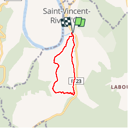
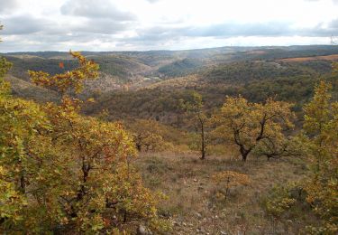
Ruta Senderismo de 4,6 km a descubrir en Occitania, Lot, Saint-Vincent-Rive-d'Olt. Esta ruta ha sido propuesta por tracegps.
Descripción
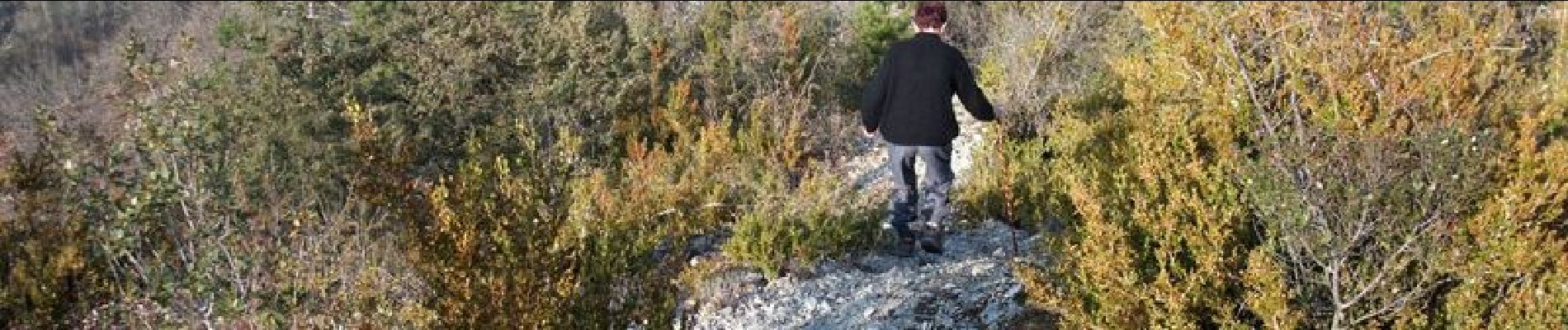
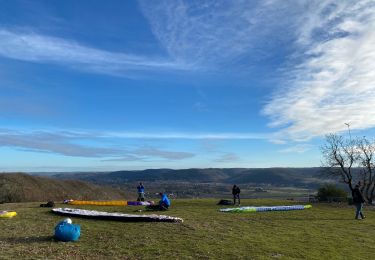
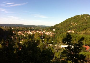
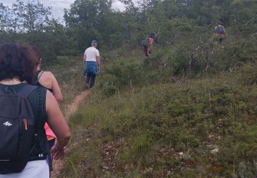
Dans le centre du village, traverser le pont devant le parking et prendre la première rue à gauche. À une fourche avec un panneau "limitation 2 t" prendre à gauche et, un peu plus loin, continuer tout droit (panneau sentier des pervenches). Devant l'entrée d'une propriété, au niveau d'une boîte aux lettres, prendre le petit sentier qui part à droite. Longer le stade et suivre le fond de la vallée. À environ 2 km du départ, quitter le sentier des pervenches et en prendre un qui monte à droite (panneau les 20 voltes, Bimbotes). Sur le plateau passer entre 2 vignes, continuer sur un chemin assez large et prendre une petite route sur la droite. Quelques centaines de mètres plus bas (environ 500 m), prendre un chemin à gauche (panneau lo Plano, point de vue). Arriver sur un espace dégagé, point de départ de parapentes, et suivre un sentier sur la crête au bord de la falaise jusqu'à une route goudronnée. Passer entre le muret et la croix et prendre un petit sentier, peu visible au début, qui descend vers Saint-Vincent. En retrouvant le goudron prendre à gauche et rejoindre le parking.
Localización
Comentarios
Excursiones cerca
![Excursión Senderismo Saint-Vincent-Rive-d'Olt - St Vincent-rive d’Holt (Lot) - Photo](https://media.geolcdn.com/t/375/260/ext.jpg?maxdim=2&url=https%3A%2F%2Fstatic1.geolcdn.com%2Fsiteimages%2Fupload%2Ffiles%2F1553511878bg_sport_marche.png)
![Senderismo Senderismo](https://static1.geolcdn.com/sitytour/trail-icons/101.png)
Senderismo
![](/images/other/stat-length.png)
![](https://static1.geolcdn.com/siteimages/upload/files/16400158638029165_repeat_loop_refresh_sync_direction_icon.png)
![Excursión Senderismo Crayssac - Crayssac Cévennes - Photo](https://media.geolcdn.com/t/375/260/f07bb3de-4c60-4431-b846-5572eb8ab419.jpg&format=jpg&maxdim=2)
![Senderismo Senderismo](https://static1.geolcdn.com/sitytour/trail-icons/101.png)
Senderismo
![](/images/other/stat-length.png)
![](https://static1.geolcdn.com/siteimages/upload/files/16400158638029165_repeat_loop_refresh_sync_direction_icon.png)
![Excursión Senderismo Luzech - De Luzech à Castelfranc - Photo](https://media.geolcdn.com/t/375/260/ext.jpg?maxdim=2&url=https%3A%2F%2Fservices.sitytrail.com%2FGeolivesWS%2FDownloadMedia.ashx%3FTrailID%3D316982%26Media%3D16106_3.jpg)
![Senderismo Senderismo](https://static1.geolcdn.com/sitytour/trail-icons/101.png)
Senderismo
![](/images/other/stat-length.png)
![](https://static1.geolcdn.com/siteimages/upload/files/16400158638029165_repeat_loop_refresh_sync_direction_icon.png)
![Excursión Senderismo Luzech - LUZECH - Photo](https://media.geolcdn.com/t/375/260/9b21fca2-bfb8-4fba-9ee0-71949b40b188.jpg&format=jpg&maxdim=2)
![Senderismo Senderismo](https://static1.geolcdn.com/sitytour/trail-icons/101.png)
![Excursión Senderismo Douelle - filles mamu aprem - Photo](https://media.geolcdn.com/t/375/260/cd9f458e-fb02-4c6e-9e6c-71d98e747b7b.jpg&format=jpg&maxdim=2)
![Senderismo Senderismo](https://static1.geolcdn.com/sitytour/trail-icons/101.png)
Senderismo
![](/images/other/stat-length.png)
![](https://static1.geolcdn.com/siteimages/upload/files/16400158638029165_repeat_loop_refresh_sync_direction_icon.png)
![Excursión Senderismo Trespoux-Rassiels - filles de manu 1juin24 - Photo](https://media.geolcdn.com/t/375/260/84f78169-4643-4282-b205-725e3a25e151.jpg&format=jpg&maxdim=2)
![Senderismo Senderismo](https://static1.geolcdn.com/sitytour/trail-icons/101.png)
Senderismo
![](/images/other/stat-length.png)
![](https://static1.geolcdn.com/siteimages/upload/files/16400158638029165_repeat_loop_refresh_sync_direction_icon.png)
![Excursión Senderismo Cambayrac - Cambeyrac - Photo](https://media.geolcdn.com/t/375/260/72c71246-2c5c-461f-8958-64c97cdfa70a.jpg&format=jpg&maxdim=2)
![Senderismo Senderismo](https://static1.geolcdn.com/sitytour/trail-icons/101.png)
![Excursión Senderismo Douelle - Douelle_Mader/Combe de Vadaillac/les Roubines 6 - Photo](https://media.geolcdn.com/t/375/260/18f1e74a-9791-4007-90e2-e99aec771378.jpg&format=jpg&maxdim=2)
![Senderismo Senderismo](https://static1.geolcdn.com/sitytour/trail-icons/101.png)
Senderismo
![](/images/other/stat-length.png)
![](https://static1.geolcdn.com/siteimages/upload/files/16400158638029165_repeat_loop_refresh_sync_direction_icon.png)
![Excursión Senderismo Luzech - Fages_Pech-vert_Foulquet 6,5 - Photo](https://media.geolcdn.com/t/375/260/338f1118-5eea-4e57-9527-5664443760c4.jpg&format=jpg&maxdim=2)
![Senderismo Senderismo](https://static1.geolcdn.com/sitytour/trail-icons/101.png)
Senderismo
![](/images/other/stat-length.png)
![](https://static1.geolcdn.com/siteimages/upload/files/16400158638029165_repeat_loop_refresh_sync_direction_icon.png)
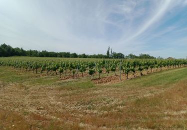
Belle promenade typique du Causse, Lot, vignes de Cahors