![](/images/other/stat-length.png)
![Excursión Bici de montaña Saint-Aubin-sur-Scie - Aux alentours de Dieppe - Photo](https://media.geolcdn.com/t/1900/400/ext.pjpeg?maxdim=2&url=https%3A%2F%2Fservices.sitytrail.com%2FGeolivesWS%2FDownloadMedia.ashx%3FTrailID%3D104693%26Media%3D8099_1.jpg)
Aux alentours de Dieppe
tracegps
Usuario
![Longitud](/images/other/stat-length.png)
Longitud
29 km
![Altitud máxima](https://static1.geolcdn.com/siteimages/upload/files/1508320355ic_sort_altitude_max_24dp.png)
Altitud máxima
136 m
![Desnivel positivo](https://static1.geolcdn.com/siteimages/upload/files/1508320355ic_sort_den_pos_24dp.png)
Desnivel positivo
394 m
![Km-Effort](/images/other/stat-length.png)
Km-Effort
34 km
![Altitud mínima](https://static1.geolcdn.com/siteimages/upload/files/1508320355ic_sort_altitude_min_24dp.png)
Altitud mínima
4 m
![Desnivel negativo](https://static1.geolcdn.com/siteimages/upload/files/1508320355ic_sort_den_neg_24dp.png)
Desnivel negativo
394 m
![Boucle](https://static1.geolcdn.com/siteimages/upload/files/16400158638029165_repeat_loop_refresh_sync_direction_icon.png)
Boucle
Sí
Fecha de creación :
2014-12-10 00:00:00.0
Última modificación :
2014-12-10 00:00:00.0
![Bici de montaña](https://static1.geolcdn.com/sitytour/trail-icons/202.png)
3h00
Dificultad : Difícil
![Escanee este código QR para abrir la excursión en la aplicación SityTrail](https://capi.geolives.com/qq0zvz2zws4bq2lad0pu/sitytour/trails/104693/qr.png?size=200)
Aplicación GPS de excursión GRATIS
A propósito
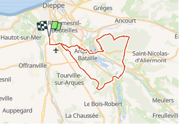
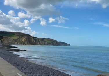
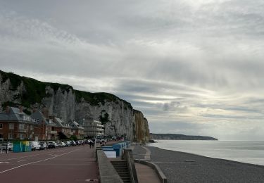
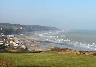
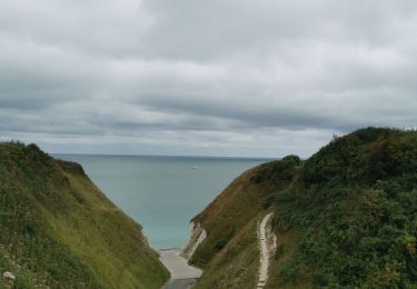
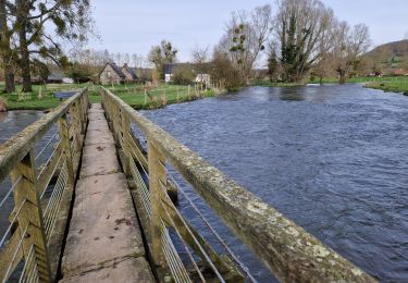
Ruta Bici de montaña de 29 km a descubrir en Normandía, Sena-Marítimo, Saint-Aubin-sur-Scie. Esta ruta ha sido propuesta por tracegps.
Descripción
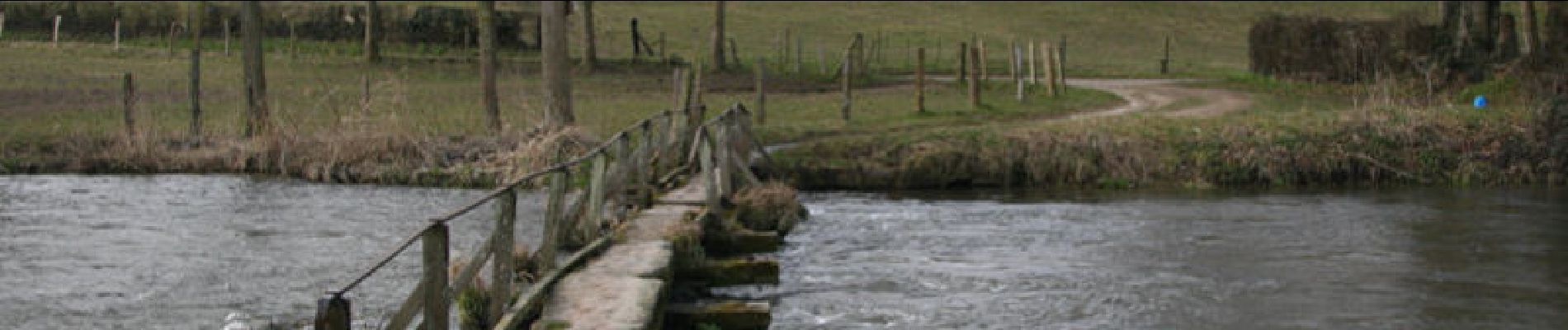
Un petit circuit joli dans les alentours de Dieppe. Il y a quelques passages difficiles, des sections non-goudronnées, des descentes et montées... un vrai plaisir...
Localización
País:
France
Región :
Normandía
Departamento/provincia :
Sena-Marítimo
Municipio :
Saint-Aubin-sur-Scie
Localidad:
Unknown
Salida:(Dec)
Salida:(UTM)
361685 ; 5528827 (31U) N.
Comentarios
Excursiones cerca
![Excursión Senderismo Varengeville-sur-Mer - Pourville jusqu'aux Terrasses de Vasterival - Photo](https://media.geolcdn.com/t/375/260/ext.jpg?maxdim=2&url=https%3A%2F%2Fstatic1.geolcdn.com%2Fsiteimages%2Fupload%2Ffiles%2F1553511878bg_sport_marche.png)
![Senderismo Senderismo](https://static1.geolcdn.com/sitytour/trail-icons/101.png)
Pourville jusqu'aux Terrasses de Vasterival
Senderismo
Fácil
(1)
Varengeville-sur-Mer,
Normandía,
Sena-Marítimo,
France
![](/images/other/stat-length.png)
11,7 km | 15,1 km-effort
3h 53min
![](https://static1.geolcdn.com/siteimages/upload/files/16400158638029165_repeat_loop_refresh_sync_direction_icon.png)
Sí
![Excursión Senderismo Dieppe - GR21 : De Dieppe à Pourville-Sur-Mer - Photo](https://media.geolcdn.com/t/375/260/9af66fc9-7eaf-4a54-b63d-df14d7092c30.jpeg&format=jpg&maxdim=2)
![Senderismo Senderismo](https://static1.geolcdn.com/sitytour/trail-icons/101.png)
GR21 : De Dieppe à Pourville-Sur-Mer
Senderismo
Fácil
Dieppe,
Normandía,
Sena-Marítimo,
France
![](/images/other/stat-length.png)
8,1 km | 10,9 km-effort
2h 27min
![](https://static1.geolcdn.com/siteimages/upload/files/16400158638029165_repeat_loop_refresh_sync_direction_icon.png)
No
![Excursión A pie Dieppe - Dieppe coté mer 1 - Photo](https://media.geolcdn.com/t/375/260/17716324-48c0-4442-af65-fedeb6808833.jpeg&format=jpg&maxdim=2)
![A pie A pie](https://static1.geolcdn.com/sitytour/trail-icons/100.png)
Dieppe coté mer 1
A pie
Muy fácil
Dieppe,
Normandía,
Sena-Marítimo,
France
![](/images/other/stat-length.png)
3,6 km | 4,1 km-effort
56min
![](https://static1.geolcdn.com/siteimages/upload/files/16400158638029165_repeat_loop_refresh_sync_direction_icon.png)
Sí
![Excursión Senderismo Hautot-sur-Mer - Autour de Varengeville-sur-Mer - Photo](https://media.geolcdn.com/t/375/260/60d902af-7cf1-469a-9cec-da74be4158a3.jpeg&format=jpg&maxdim=2)
![Senderismo Senderismo](https://static1.geolcdn.com/sitytour/trail-icons/101.png)
Autour de Varengeville-sur-Mer
Senderismo
Medio
Hautot-sur-Mer,
Normandía,
Sena-Marítimo,
France
![](/images/other/stat-length.png)
20 km | 26 km-effort
4h 19min
![](https://static1.geolcdn.com/siteimages/upload/files/16400158638029165_repeat_loop_refresh_sync_direction_icon.png)
Sí
![Excursión Senderismo Hautot-sur-Mer - Petit Appeville vers Pourville sur mer - Photo](https://media.geolcdn.com/t/375/260/f27eecc9-b419-4f96-979b-ca5c51e90ae0.jpg&format=jpg&maxdim=2)
![Senderismo Senderismo](https://static1.geolcdn.com/sitytour/trail-icons/101.png)
Petit Appeville vers Pourville sur mer
Senderismo
Medio
Hautot-sur-Mer,
Normandía,
Sena-Marítimo,
France
![](/images/other/stat-length.png)
11,5 km | 14,9 km-effort
3h 12min
![](https://static1.geolcdn.com/siteimages/upload/files/16400158638029165_repeat_loop_refresh_sync_direction_icon.png)
Sí
![Excursión Senderismo Petit-Caux - bracquemont belleville - Photo](https://media.geolcdn.com/t/375/260/da3850e3-aaac-4075-9ca6-53fbc3d5c050.jpg&format=jpg&maxdim=2)
![Senderismo Senderismo](https://static1.geolcdn.com/sitytour/trail-icons/101.png)
bracquemont belleville
Senderismo
Muy fácil
Petit-Caux,
Normandía,
Sena-Marítimo,
France
![](/images/other/stat-length.png)
7,3 km | 8,7 km-effort
1h 54min
![](https://static1.geolcdn.com/siteimages/upload/files/16400158638029165_repeat_loop_refresh_sync_direction_icon.png)
Sí
![Bici eléctrica Bici eléctrica](https://static1.geolcdn.com/sitytour/trail-icons/205.png)
Dieppe, sur la trace des impressionnistes
Bici eléctrica
Medio
Dieppe,
Normandía,
Sena-Marítimo,
France
![](/images/other/stat-length.png)
48 km | 54 km-effort
4h 0min
![](https://static1.geolcdn.com/siteimages/upload/files/16400158638029165_repeat_loop_refresh_sync_direction_icon.png)
Sí
![Excursión Senderismo Arques-la-Bataille - Arques-la-Bataille 16 03 2024 - Photo](https://media.geolcdn.com/t/375/260/0c00a518-0b31-446c-85a9-d8fed485b0a0.jpg&format=jpg&maxdim=2)
![Senderismo Senderismo](https://static1.geolcdn.com/sitytour/trail-icons/101.png)
Arques-la-Bataille 16 03 2024
Senderismo
Muy difícil
Arques-la-Bataille,
Normandía,
Sena-Marítimo,
France
![](/images/other/stat-length.png)
22 km | 28 km-effort
6h 23min
![](https://static1.geolcdn.com/siteimages/upload/files/16400158638029165_repeat_loop_refresh_sync_direction_icon.png)
Sí
![Excursión Bici de carretera Offranville - Of Granville Pourville - Photo](https://media.geolcdn.com/t/375/260/d8c6b403-a0c5-4f90-840f-e0163a917f1c.jpg&format=jpg&maxdim=2)
![Bici de carretera Bici de carretera](https://static1.geolcdn.com/sitytour/trail-icons/201.png)
Of Granville Pourville
Bici de carretera
Offranville,
Normandía,
Sena-Marítimo,
France
![](/images/other/stat-length.png)
31 km | 34 km-effort
2h 22min
![](https://static1.geolcdn.com/siteimages/upload/files/16400158638029165_repeat_loop_refresh_sync_direction_icon.png)
Sí