![](/images/other/stat-length.png)
![Excursión Senderismo Saint-Barthélemy-Grozon - Saint Bathelemy - Grozon - Photo](https://media.geolcdn.com/t/1900/400/ext.pjpeg?maxdim=2&url=https%3A%2F%2Fstatic1.geolcdn.com%2Fsiteimages%2Fupload%2Ffiles%2F1553511878bg_sport_marche.png)
Saint Bathelemy - Grozon
tracegps
Usuario
![Longitud](/images/other/stat-length.png)
Longitud
10,2 km
![Altitud máxima](https://static1.geolcdn.com/siteimages/upload/files/1508320355ic_sort_altitude_max_24dp.png)
Altitud máxima
787 m
![Desnivel positivo](https://static1.geolcdn.com/siteimages/upload/files/1508320355ic_sort_den_pos_24dp.png)
Desnivel positivo
250 m
![Km-Effort](/images/other/stat-length.png)
Km-Effort
13,6 km
![Altitud mínima](https://static1.geolcdn.com/siteimages/upload/files/1508320355ic_sort_altitude_min_24dp.png)
Altitud mínima
649 m
![Desnivel negativo](https://static1.geolcdn.com/siteimages/upload/files/1508320355ic_sort_den_neg_24dp.png)
Desnivel negativo
254 m
![Boucle](https://static1.geolcdn.com/siteimages/upload/files/16400158638029165_repeat_loop_refresh_sync_direction_icon.png)
Boucle
Sí
Fecha de creación :
2014-12-10 00:00:00.0
Última modificación :
2014-12-10 00:00:00.0
![Senderismo](https://static1.geolcdn.com/sitytour/trail-icons/101.png)
3h00
Dificultad : Medio
![Escanee este código QR para abrir la excursión en la aplicación SityTrail](https://capi.geolives.com/qq0zvz2zws4bq2lad0pu/sitytour/trails/104340/qr.png?size=200)
Aplicación GPS de excursión GRATIS
A propósito
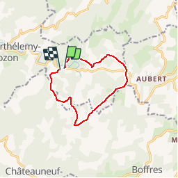
Ruta Senderismo de 10,2 km a descubrir en Auvergne-Rhône-Alpes, Ardecha, Saint-Barthélemy-Grozon. Esta ruta ha sido propuesta por tracegps.
Descripción
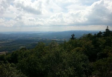
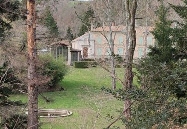
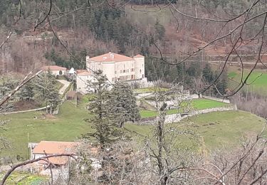
Cette boucle peut démarrer également à partir du "Col des Fans" où il est possible de stationner. Belle vue sur la vallée du Rhône, les Alpes et les Montagnes d'Ardèche.
Localización
País:
France
Región :
Auvergne-Rhône-Alpes
Departamento/provincia :
Ardecha
Municipio :
Saint-Barthélemy-Grozon
Localidad:
Unknown
Salida:(Dec)
Salida:(UTM)
631124 ; 4979418 (31T) N.
Comentarios
Excursiones cerca
![Excursión Senderismo Châteauneuf-de-Vernoux - Serre de la Roue - Photo](https://media.geolcdn.com/t/375/260/ext.jpg?maxdim=2&url=https%3A%2F%2Fservices.sitytrail.com%2FGeolivesWS%2FDownloadMedia.ashx%3FTrailID%3D217259%26Media%3Dfix__20130828152259.jpg)
![Senderismo Senderismo](https://static1.geolcdn.com/sitytour/trail-icons/101.png)
Serre de la Roue
Senderismo
Fácil
(1)
Châteauneuf-de-Vernoux,
Auvergne-Rhône-Alpes,
Ardecha,
France
![](/images/other/stat-length.png)
10,1 km | 14,9 km-effort
3h 7min
![](https://static1.geolcdn.com/siteimages/upload/files/16400158638029165_repeat_loop_refresh_sync_direction_icon.png)
Sí
![Excursión Senderismo Saint-Barthélemy-Grozon - GROZON - Photo](https://media.geolcdn.com/t/375/260/87aac2a8-1c03-4fc1-ac63-ec689ae6d983.jpg&format=jpg&maxdim=2)
![Senderismo Senderismo](https://static1.geolcdn.com/sitytour/trail-icons/101.png)
GROZON
Senderismo
Fácil
Saint-Barthélemy-Grozon,
Auvergne-Rhône-Alpes,
Ardecha,
France
![](/images/other/stat-length.png)
17 km | 23 km-effort
4h 58min
![](https://static1.geolcdn.com/siteimages/upload/files/16400158638029165_repeat_loop_refresh_sync_direction_icon.png)
Sí
![Excursión Senderismo Boffres - boffre 07 - Photo](https://media.geolcdn.com/t/375/260/ext.jpg?maxdim=2&url=https%3A%2F%2Fstatic1.geolcdn.com%2Fsiteimages%2Fupload%2Ffiles%2F1553511878bg_sport_marche.png)
![Senderismo Senderismo](https://static1.geolcdn.com/sitytour/trail-icons/101.png)
boffre 07
Senderismo
Muy fácil
(1)
Boffres,
Auvergne-Rhône-Alpes,
Ardecha,
France
![](/images/other/stat-length.png)
12,5 km | 16,9 km-effort
4h 25min
![](https://static1.geolcdn.com/siteimages/upload/files/16400158638029165_repeat_loop_refresh_sync_direction_icon.png)
Sí
![Excursión Senderismo Châteauneuf-de-Vernoux - Serre du Turc - Châteauneuf de Vernoux - Photo](https://media.geolcdn.com/t/375/260/ext.jpg?maxdim=2&url=https%3A%2F%2Fservices.sitytrail.com%2FGeolivesWS%2FDownloadMedia.ashx%3FTrailID%3D191359%26Media%3D14923_6.jpg)
![Senderismo Senderismo](https://static1.geolcdn.com/sitytour/trail-icons/101.png)
Serre du Turc - Châteauneuf de Vernoux
Senderismo
Difícil
Châteauneuf-de-Vernoux,
Auvergne-Rhône-Alpes,
Ardecha,
France
![](/images/other/stat-length.png)
11,7 km | 16,4 km-effort
3h 30min
![](https://static1.geolcdn.com/siteimages/upload/files/16400158638029165_repeat_loop_refresh_sync_direction_icon.png)
Sí
![Excursión Senderismo Gilhoc-sur-Ormèze - col de st genet - Photo](https://media.geolcdn.com/t/375/260/8ffaa862-a954-444c-bb1f-0fc27c34a4ba.jpg&format=jpg&maxdim=2)
![Senderismo Senderismo](https://static1.geolcdn.com/sitytour/trail-icons/101.png)
col de st genet
Senderismo
Difícil
Gilhoc-sur-Ormèze,
Auvergne-Rhône-Alpes,
Ardecha,
France
![](/images/other/stat-length.png)
8,5 km | 12 km-effort
2h 8min
![](https://static1.geolcdn.com/siteimages/upload/files/16400158638029165_repeat_loop_refresh_sync_direction_icon.png)
Sí
![Excursión Senderismo Gilhoc-sur-Ormèze - 07 gilhoc sur ormeze - Photo](https://media.geolcdn.com/t/375/260/ext.jpg?maxdim=2&url=https%3A%2F%2Fstatic1.geolcdn.com%2Fsiteimages%2Fupload%2Ffiles%2F1553511878bg_sport_marche.png)
![Senderismo Senderismo](https://static1.geolcdn.com/sitytour/trail-icons/101.png)
07 gilhoc sur ormeze
Senderismo
Medio
Gilhoc-sur-Ormèze,
Auvergne-Rhône-Alpes,
Ardecha,
France
![](/images/other/stat-length.png)
18,4 km | 25 km-effort
4h 57min
![](https://static1.geolcdn.com/siteimages/upload/files/16400158638029165_repeat_loop_refresh_sync_direction_icon.png)
No
![Excursión Senderismo Gilhoc-sur-Ormèze - Le col de Saint Genest - Photo](https://media.geolcdn.com/t/375/260/f29e4798-d89e-4955-b191-7edfb3e75dde.jpg&format=jpg&maxdim=2)
![Senderismo Senderismo](https://static1.geolcdn.com/sitytour/trail-icons/101.png)
Le col de Saint Genest
Senderismo
Muy fácil
Gilhoc-sur-Ormèze,
Auvergne-Rhône-Alpes,
Ardecha,
France
![](/images/other/stat-length.png)
8,4 km | 11,9 km-effort
2h 22min
![](https://static1.geolcdn.com/siteimages/upload/files/16400158638029165_repeat_loop_refresh_sync_direction_icon.png)
Sí
![Excursión Motor Boffres - sortie 3 jours Ardèche - Photo](https://media.geolcdn.com/t/375/260/ext.jpg?maxdim=2&url=https%3A%2F%2Fservices.sitytrail.com%2FGeolivesWS%2FDownloadMedia.ashx%3FTrailID%3D925390%26Media%3D20180303124747.jpg)
![Motor Motor](https://static1.geolcdn.com/sitytour/trail-icons/400.png)
sortie 3 jours Ardèche
Motor
Muy fácil
Boffres,
Auvergne-Rhône-Alpes,
Ardecha,
France
![](/images/other/stat-length.png)
595 km | 769 km-effort
108h 19min
![](https://static1.geolcdn.com/siteimages/upload/files/16400158638029165_repeat_loop_refresh_sync_direction_icon.png)
No
![Excursión Senderismo Boffres - 07 boffres - Photo](https://media.geolcdn.com/t/375/260/ext.jpg?maxdim=2&url=https%3A%2F%2Fstatic1.geolcdn.com%2Fsiteimages%2Fupload%2Ffiles%2F1553511878bg_sport_marche.png)
![Senderismo Senderismo](https://static1.geolcdn.com/sitytour/trail-icons/101.png)
07 boffres
Senderismo
Fácil
Boffres,
Auvergne-Rhône-Alpes,
Ardecha,
France
![](/images/other/stat-length.png)
11,6 km | 15,7 km-effort
3h 55min
![](https://static1.geolcdn.com/siteimages/upload/files/16400158638029165_repeat_loop_refresh_sync_direction_icon.png)
No