![](/images/other/stat-length.png)
![Excursión Senderismo Buhl - Le Hohrupf depuis Buhl - Photo](https://media.geolcdn.com/t/1900/400/ext.pjpeg?maxdim=2&url=https%3A%2F%2Fservices.sitytrail.com%2FGeolivesWS%2FDownloadMedia.ashx%3FTrailID%3D104328%26Media%3D7560_4.jpg)
Le Hohrupf depuis Buhl
tracegps
Usuario
![Longitud](/images/other/stat-length.png)
![Altitud máxima](https://static1.geolcdn.com/siteimages/upload/files/1508320355ic_sort_altitude_max_24dp.png)
![Desnivel positivo](https://static1.geolcdn.com/siteimages/upload/files/1508320355ic_sort_den_pos_24dp.png)
![Km-Effort](/images/other/stat-length.png)
![Altitud mínima](https://static1.geolcdn.com/siteimages/upload/files/1508320355ic_sort_altitude_min_24dp.png)
![Desnivel negativo](https://static1.geolcdn.com/siteimages/upload/files/1508320355ic_sort_den_neg_24dp.png)
![Boucle](https://static1.geolcdn.com/siteimages/upload/files/16400158638029165_repeat_loop_refresh_sync_direction_icon.png)
![Senderismo](https://static1.geolcdn.com/sitytour/trail-icons/101.png)
3h00
Dificultad : Medio
![Escanee este código QR para abrir la excursión en la aplicación SityTrail](https://capi.geolives.com/qq0zvz2zws4bq2lad0pu/sitytour/trails/104328/qr.png?size=200)
Aplicación GPS de excursión GRATIS
A propósito
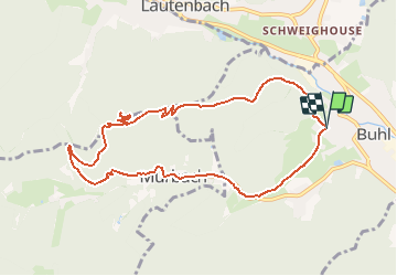
Ruta Senderismo de 9,5 km a descubrir en Gran Este, Alto Rin, Buhl. Esta ruta ha sido propuesta por tracegps.
Descripción
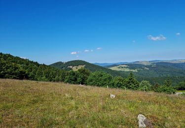
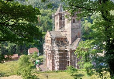
Le château du Hohrupf a été édifié au 13e siècle pour protéger l'abbaye de Murbach. Perché sur un belvédère à une altitude de 813m, il ne subsiste plus que quelques ruines, mais le panorama 360° vaut le détour. Le circuit part de Buhl et rejoint le Hohrupf par une pente régulière en 1h15. Au retour nous avons fait un détour par le col du Wolfsgrübe et par l'abbaye de Mürbach qui vaut bien une petite visite.
Localización
Comentarios
Excursiones cerca
![Excursión A pie Goldbach-Altenbach - Firstacker - Willer sur Thur - Photo](https://media.geolcdn.com/t/375/260/203caa2b-07d7-4c6d-9f37-990a5db6b7c9.jpeg&format=jpg&maxdim=2)
![A pie A pie](https://static1.geolcdn.com/sitytour/trail-icons/100.png)
A pie
![](/images/other/stat-length.png)
![](https://static1.geolcdn.com/siteimages/upload/files/16400158638029165_repeat_loop_refresh_sync_direction_icon.png)
![Excursión Bici de montaña Guebwiller - P4 Circuits du Florival 2021 - Photo](https://media.geolcdn.com/t/375/260/ext.jpg?maxdim=2&url=https%3A%2F%2Fstatic1.geolcdn.com%2Fsiteimages%2Fupload%2Ffiles%2F1524743154velo.jpg)
![Bici de montaña Bici de montaña](https://static1.geolcdn.com/sitytour/trail-icons/202.png)
Bici de montaña
![](/images/other/stat-length.png)
![](https://static1.geolcdn.com/siteimages/upload/files/16400158638029165_repeat_loop_refresh_sync_direction_icon.png)
![Excursión Senderismo Buhl - AMAELLES - Rando 06/01/2025 - Bulh - Photo](https://media.geolcdn.com/t/375/260/7d3c9dff-b15b-4c79-abbd-c40015be5ccd.jpg&format=jpg&maxdim=2)
![Senderismo Senderismo](https://static1.geolcdn.com/sitytour/trail-icons/101.png)
Senderismo
![](/images/other/stat-length.png)
![](https://static1.geolcdn.com/siteimages/upload/files/16400158638029165_repeat_loop_refresh_sync_direction_icon.png)
![Excursión Senderismo Murbach - Rando du 01/08/2024 - Photo](https://media.geolcdn.com/t/375/260/972ef580-7975-4588-9d8a-4f59c51fac03.jpg&format=jpg&maxdim=2)
![Senderismo Senderismo](https://static1.geolcdn.com/sitytour/trail-icons/101.png)
Senderismo
![](/images/other/stat-length.png)
![](https://static1.geolcdn.com/siteimages/upload/files/16400158638029165_repeat_loop_refresh_sync_direction_icon.png)
![Excursión Senderismo Soultz-Haut-Rhin - Rando Marcheurs..04/04_2025 - Photo](https://media.geolcdn.com/t/375/260/2ab5dad5-2554-412a-abd7-9d4222ed2a04.jpg&format=jpg&maxdim=2)
![Senderismo Senderismo](https://static1.geolcdn.com/sitytour/trail-icons/101.png)
Senderismo
![](/images/other/stat-length.png)
![](https://static1.geolcdn.com/siteimages/upload/files/16400158638029165_repeat_loop_refresh_sync_direction_icon.png)
![Excursión Senderismo Buhl - TL 11/23 avec un petit tour dans le vignoble avec départ du parking Côte de l'Appenthal et repas à la Taverne du Vigneron - Photo](https://media.geolcdn.com/t/375/260/ext.jpg?maxdim=2&url=https%3A%2F%2Fstatic1.geolcdn.com%2Fsiteimages%2Fupload%2Ffiles%2F1553511878bg_sport_marche.png)
![Senderismo Senderismo](https://static1.geolcdn.com/sitytour/trail-icons/101.png)
Senderismo
![](/images/other/stat-length.png)
![](https://static1.geolcdn.com/siteimages/upload/files/16400158638029165_repeat_loop_refresh_sync_direction_icon.png)
![Excursión Senderismo Murbach - La](https://media.geolcdn.com/t/375/260/8fe6d1de-df6a-41e4-9b00-4e4813a84689.jpg&format=jpg&maxdim=2)
![Senderismo Senderismo](https://static1.geolcdn.com/sitytour/trail-icons/101.png)
Senderismo
![](/images/other/stat-length.png)
![](https://static1.geolcdn.com/siteimages/upload/files/16400158638029165_repeat_loop_refresh_sync_direction_icon.png)
![Excursión Senderismo Murbach - Murbach - Photo](https://media.geolcdn.com/t/375/260/89fa0564-5ffd-4352-bc67-bdcfedc91e4a.jpg&format=jpg&maxdim=2)
![Senderismo Senderismo](https://static1.geolcdn.com/sitytour/trail-icons/101.png)
![Excursión Senderismo Soultzmatt - Rando du 30/03/2034 - Photo](https://media.geolcdn.com/t/375/260/2df2f586-a5de-43a9-98d8-69a4789f2321.jpg&format=jpg&maxdim=2)
![Senderismo Senderismo](https://static1.geolcdn.com/sitytour/trail-icons/101.png)
Senderismo
![](/images/other/stat-length.png)
![](https://static1.geolcdn.com/siteimages/upload/files/16400158638029165_repeat_loop_refresh_sync_direction_icon.png)