![](/images/other/stat-length.png)
![Excursión Bici de montaña La Ferté-Saint-Aubin - La Ferté St Anbin - Vouzon - Photo](https://media.geolcdn.com/t/1900/400/ext.pjpeg?maxdim=2&url=https%3A%2F%2Fservices.sitytrail.com%2FGeolivesWS%2FDownloadMedia.ashx%3FTrailID%3D103899%26Media%3D6725_3.jpg)
La Ferté St Anbin - Vouzon
tracegps
Usuario
![Longitud](/images/other/stat-length.png)
Longitud
37 km
![Altitud máxima](https://static1.geolcdn.com/siteimages/upload/files/1508320355ic_sort_altitude_max_24dp.png)
Altitud máxima
155 m
![Desnivel positivo](https://static1.geolcdn.com/siteimages/upload/files/1508320355ic_sort_den_pos_24dp.png)
Desnivel positivo
298 m
![Km-Effort](/images/other/stat-length.png)
Km-Effort
40 km
![Altitud mínima](https://static1.geolcdn.com/siteimages/upload/files/1508320355ic_sort_altitude_min_24dp.png)
Altitud mínima
100 m
![Desnivel negativo](https://static1.geolcdn.com/siteimages/upload/files/1508320355ic_sort_den_neg_24dp.png)
Desnivel negativo
293 m
![Boucle](https://static1.geolcdn.com/siteimages/upload/files/16400158638029165_repeat_loop_refresh_sync_direction_icon.png)
Boucle
Sí
Fecha de creación :
2014-12-10 00:00:00.0
Última modificación :
2014-12-10 00:00:00.0
![Bici de montaña](https://static1.geolcdn.com/sitytour/trail-icons/202.png)
3h00
Dificultad : Medio
![Escanee este código QR para abrir la excursión en la aplicación SityTrail](https://capi.geolives.com/qq0zvz2zws4bq2lad0pu/sitytour/trails/103899/qr.png?size=200)
Aplicación GPS de excursión GRATIS
A propósito
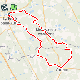
Ruta Bici de montaña de 37 km a descubrir en Centro, Loiret, La Ferté-Saint-Aubin. Esta ruta ha sido propuesta por tracegps.
Descripción
Départ du parking du château de la Ferté Saint Aubin vers Vouzon par les GR de Sologne et retour par Ménestreau en Villette et la rive du Cosson.
Localización
País:
France
Región :
Centro
Departamento/provincia :
Loiret
Municipio :
La Ferté-Saint-Aubin
Localidad:
Unknown
Salida:(Dec)
Salida:(UTM)
420685 ; 5286415 (31T) N.
Comentarios
Excursiones cerca
![Excursión Bici de montaña La Ferté-Saint-Aubin - La ferté - Yvoy le marron - Photo](https://media.geolcdn.com/t/375/260/ext.jpg?maxdim=2&url=https%3A%2F%2Fservices.sitytrail.com%2FGeolivesWS%2FDownloadMedia.ashx%3FTrailID%3D722694%26Media%3D20170329165819.jpg)
![Bici de montaña Bici de montaña](https://static1.geolcdn.com/sitytour/trail-icons/202.png)
La ferté - Yvoy le marron
Bici de montaña
Fácil
La Ferté-Saint-Aubin,
Centro,
Loiret,
France
![](/images/other/stat-length.png)
23 km | 26 km-effort
2h 23min
![](https://static1.geolcdn.com/siteimages/upload/files/16400158638029165_repeat_loop_refresh_sync_direction_icon.png)
Sí
![Excursión Senderismo La Ferté-Saint-Aubin - LA FERTE ST AUBIN - Photo](https://media.geolcdn.com/t/375/260/ext.jpg?maxdim=2&url=https%3A%2F%2Fstatic1.geolcdn.com%2Fsiteimages%2Fupload%2Ffiles%2F1553511878bg_sport_marche.png)
![Senderismo Senderismo](https://static1.geolcdn.com/sitytour/trail-icons/101.png)
LA FERTE ST AUBIN
Senderismo
Muy fácil
La Ferté-Saint-Aubin,
Centro,
Loiret,
France
![](/images/other/stat-length.png)
7,5 km | 8,3 km-effort
1h 50min
![](https://static1.geolcdn.com/siteimages/upload/files/16400158638029165_repeat_loop_refresh_sync_direction_icon.png)
Sí
![Excursión Bicicleta híbrida La Ferté-Saint-Aubin - De la Ferté St aubin à Mézières lez Cléry - Photo](https://media.geolcdn.com/t/375/260/ext.jpg?maxdim=2&url=https%3A%2F%2Fstatic1.geolcdn.com%2Fsiteimages%2Fupload%2Ffiles%2F1524743154velo.jpg)
![Bicicleta híbrida Bicicleta híbrida](https://static1.geolcdn.com/sitytour/trail-icons/203.png)
De la Ferté St aubin à Mézières lez Cléry
Bicicleta híbrida
Fácil
La Ferté-Saint-Aubin,
Centro,
Loiret,
France
![](/images/other/stat-length.png)
19,1 km | 21 km-effort
2h 3min
![](https://static1.geolcdn.com/siteimages/upload/files/16400158638029165_repeat_loop_refresh_sync_direction_icon.png)
No
![Excursión Bici de montaña La Ferté-Saint-Aubin - VTT 36km La Ferté Chaumont Yvoy - Photo](https://media.geolcdn.com/t/375/260/ext.jpg?maxdim=2&url=https%3A%2F%2Fstatic1.geolcdn.com%2Fsiteimages%2Fupload%2Ffiles%2F1524743154velo.jpg)
![Bici de montaña Bici de montaña](https://static1.geolcdn.com/sitytour/trail-icons/202.png)
VTT 36km La Ferté Chaumont Yvoy
Bici de montaña
Muy fácil
La Ferté-Saint-Aubin,
Centro,
Loiret,
France
![](/images/other/stat-length.png)
36 km | 40 km-effort
2h 49min
![](https://static1.geolcdn.com/siteimages/upload/files/16400158638029165_repeat_loop_refresh_sync_direction_icon.png)
Sí
![Excursión Senderismo La Ferté-Saint-Aubin - La Ferté-Saint -Aubin PR du Mazuray - Photo](https://media.geolcdn.com/t/375/260/ext.jpg?maxdim=2&url=https%3A%2F%2Fstatic1.geolcdn.com%2Fsiteimages%2Fupload%2Ffiles%2F1553511878bg_sport_marche.png)
![Senderismo Senderismo](https://static1.geolcdn.com/sitytour/trail-icons/101.png)
La Ferté-Saint -Aubin PR du Mazuray
Senderismo
Fácil
La Ferté-Saint-Aubin,
Centro,
Loiret,
France
![](/images/other/stat-length.png)
12,5 km | 13,9 km-effort
3h 3min
![](https://static1.geolcdn.com/siteimages/upload/files/16400158638029165_repeat_loop_refresh_sync_direction_icon.png)
Sí
![Excursión Bici de montaña La Ferté-Saint-Aubin - 2010-09-19 LFSA - Lamothe Beuvron - Photo](https://media.geolcdn.com/t/375/260/ext.jpg?maxdim=2&url=https%3A%2F%2Fstatic1.geolcdn.com%2Fsiteimages%2Fupload%2Ffiles%2F1524743154velo.jpg)
![Bici de montaña Bici de montaña](https://static1.geolcdn.com/sitytour/trail-icons/202.png)
2010-09-19 LFSA - Lamothe Beuvron
Bici de montaña
Muy fácil
La Ferté-Saint-Aubin,
Centro,
Loiret,
France
![](/images/other/stat-length.png)
51 km | 57 km-effort
Desconocido
![](https://static1.geolcdn.com/siteimages/upload/files/16400158638029165_repeat_loop_refresh_sync_direction_icon.png)
Sí
![Excursión Senderismo La Ferté-Saint-Aubin - la fierté menestreau - Photo](https://media.geolcdn.com/t/375/260/ext.jpg?maxdim=2&url=https%3A%2F%2Fstatic1.geolcdn.com%2Fsiteimages%2Fupload%2Ffiles%2F1553511878bg_sport_marche.png)
![Senderismo Senderismo](https://static1.geolcdn.com/sitytour/trail-icons/101.png)
la fierté menestreau
Senderismo
Difícil
La Ferté-Saint-Aubin,
Centro,
Loiret,
France
![](/images/other/stat-length.png)
12,5 km | 13,8 km-effort
2h 29min
![](https://static1.geolcdn.com/siteimages/upload/files/16400158638029165_repeat_loop_refresh_sync_direction_icon.png)
Sí
![Excursión Senderismo La Ferté-Saint-Aubin - la lumière route des traues - Photo](https://media.geolcdn.com/t/375/260/ext.jpg?maxdim=2&url=https%3A%2F%2Fstatic1.geolcdn.com%2Fsiteimages%2Fupload%2Ffiles%2F1553511878bg_sport_marche.png)
![Senderismo Senderismo](https://static1.geolcdn.com/sitytour/trail-icons/101.png)
la lumière route des traues
Senderismo
Muy fácil
La Ferté-Saint-Aubin,
Centro,
Loiret,
France
![](/images/other/stat-length.png)
10,5 km | 11,9 km-effort
2h 12min
![](https://static1.geolcdn.com/siteimages/upload/files/16400158638029165_repeat_loop_refresh_sync_direction_icon.png)
Sí
![Excursión Senderismo La Ferté-Saint-Aubin - les trays - Photo](https://media.geolcdn.com/t/375/260/ext.jpg?maxdim=2&url=https%3A%2F%2Fstatic1.geolcdn.com%2Fsiteimages%2Fupload%2Ffiles%2F1553511878bg_sport_marche.png)
![Senderismo Senderismo](https://static1.geolcdn.com/sitytour/trail-icons/101.png)
les trays
Senderismo
Fácil
La Ferté-Saint-Aubin,
Centro,
Loiret,
France
![](/images/other/stat-length.png)
11,6 km | 12,6 km-effort
2h 7min
![](https://static1.geolcdn.com/siteimages/upload/files/16400158638029165_repeat_loop_refresh_sync_direction_icon.png)
Sí