![](/images/other/stat-length.png)
![Excursión Senderismo Ceyreste - Les Balcons de Ceyreste - Photo](https://media.geolcdn.com/t/1900/400/ext.pjpeg?maxdim=2&url=https%3A%2F%2Fservices.sitytrail.com%2FGeolivesWS%2FDownloadMedia.ashx%3FTrailID%3D103844%26Media%3D6638_1.jpg)
Les Balcons de Ceyreste
tracegps
Usuario
![Longitud](/images/other/stat-length.png)
Longitud
11,3 km
![Altitud máxima](https://static1.geolcdn.com/siteimages/upload/files/1508320355ic_sort_altitude_max_24dp.png)
Altitud máxima
518 m
![Desnivel positivo](https://static1.geolcdn.com/siteimages/upload/files/1508320355ic_sort_den_pos_24dp.png)
Desnivel positivo
435 m
![Km-Effort](/images/other/stat-length.png)
Km-Effort
17,1 km
![Altitud mínima](https://static1.geolcdn.com/siteimages/upload/files/1508320355ic_sort_altitude_min_24dp.png)
Altitud mínima
122 m
![Desnivel negativo](https://static1.geolcdn.com/siteimages/upload/files/1508320355ic_sort_den_neg_24dp.png)
Desnivel negativo
446 m
![Boucle](https://static1.geolcdn.com/siteimages/upload/files/16400158638029165_repeat_loop_refresh_sync_direction_icon.png)
Boucle
Sí
Fecha de creación :
2014-12-10 00:00:00.0
Última modificación :
2014-12-10 00:00:00.0
![Senderismo](https://static1.geolcdn.com/sitytour/trail-icons/101.png)
3h00
Dificultad : Medio
![Escanee este código QR para abrir la excursión en la aplicación SityTrail](https://capi.geolives.com/qq0zvz2zws4bq2lad0pu/sitytour/trails/103844/qr.png?size=200)
Aplicación GPS de excursión GRATIS
A propósito
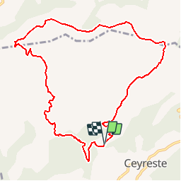
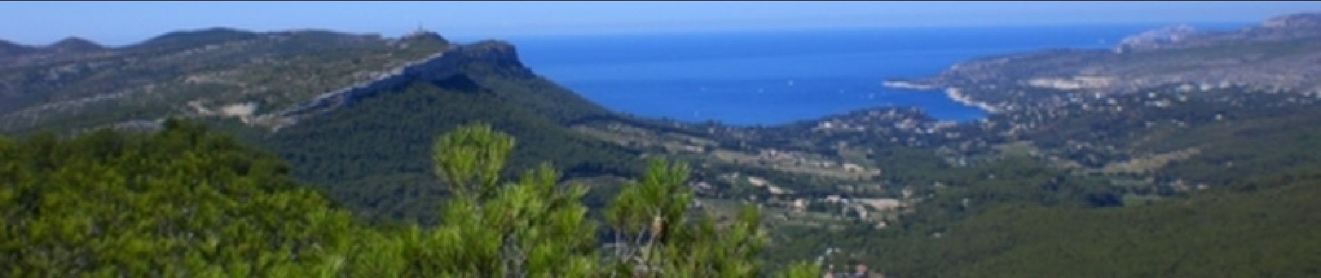
Ruta Senderismo de 11,3 km a descubrir en Provenza-Alpes-Costa Azul, Bocas del Ródano, Ceyreste. Esta ruta ha sido propuesta por tracegps.
Descripción
La première partie en montée continue est un peu longue. Le chemin est agréable. Difficulté moyenne. Retrouvez d’autres informations sur le site de Rando Loisirs à Carnoux en Provence.
Localización
País:
France
Región :
Provenza-Alpes-Costa Azul
Departamento/provincia :
Bocas del Ródano
Municipio :
Ceyreste
Localidad:
Unknown
Salida:(Dec)
Salida:(UTM)
713547 ; 4788811 (31T) N.
Comentarios
Excursiones cerca
![Excursión Senderismo Roquefort-la-Bédoule - Grand Caunet, le Montounier - Photo](https://media.geolcdn.com/t/375/260/6da96041-d8db-45b9-9840-88b8ee06ae33.jpg&format=jpg&maxdim=2)
![Senderismo Senderismo](https://static1.geolcdn.com/sitytour/trail-icons/101.png)
Grand Caunet, le Montounier
Senderismo
Medio
(1)
Roquefort-la-Bédoule,
Provenza-Alpes-Costa Azul,
Bocas del Ródano,
France
![](/images/other/stat-length.png)
16,5 km | 24 km-effort
6h 0min
![](https://static1.geolcdn.com/siteimages/upload/files/16400158638029165_repeat_loop_refresh_sync_direction_icon.png)
Sí
![Excursión Senderismo Ceyreste - Autour du Montounier 2eme version - Photo](https://media.geolcdn.com/t/375/260/aea50e59-26c4-4704-b6d5-ac40178213cc.jpg&format=jpg&maxdim=2)
![Senderismo Senderismo](https://static1.geolcdn.com/sitytour/trail-icons/101.png)
Autour du Montounier 2eme version
Senderismo
Medio
(1)
Ceyreste,
Provenza-Alpes-Costa Azul,
Bocas del Ródano,
France
![](/images/other/stat-length.png)
15,7 km | 24 km-effort
6h 0min
![](https://static1.geolcdn.com/siteimages/upload/files/16400158638029165_repeat_loop_refresh_sync_direction_icon.png)
Sí
![Excursión Senderismo Roquefort-la-Bédoule - SityTrail - Grand Caunet, Cabanons, Vigie , Grotte Raymond, Ruines roquefort, Chapelle St andré - Photo](https://media.geolcdn.com/t/375/260/f9c0beb6-6483-4b14-ba76-b33fa5e2208b.jpg&format=jpg&maxdim=2)
![Senderismo Senderismo](https://static1.geolcdn.com/sitytour/trail-icons/101.png)
SityTrail - Grand Caunet, Cabanons, Vigie , Grotte Raymond, Ruines roquefort,...
Senderismo
Fácil
(1)
Roquefort-la-Bédoule,
Provenza-Alpes-Costa Azul,
Bocas del Ródano,
France
![](/images/other/stat-length.png)
14,2 km | 19,9 km-effort
6h 0min
![](https://static1.geolcdn.com/siteimages/upload/files/16400158638029165_repeat_loop_refresh_sync_direction_icon.png)
Sí
![Excursión Senderismo Cassis - SityTrail - cassis la couronne - Photo](https://media.geolcdn.com/t/375/260/3dbefdc1-c4a5-41cb-82fb-882826196b25.jpg&format=jpg&maxdim=2)
![Senderismo Senderismo](https://static1.geolcdn.com/sitytour/trail-icons/101.png)
SityTrail - cassis la couronne
Senderismo
Medio
(3)
Cassis,
Provenza-Alpes-Costa Azul,
Bocas del Ródano,
France
![](/images/other/stat-length.png)
16,1 km | 24 km-effort
6h 0min
![](https://static1.geolcdn.com/siteimages/upload/files/16400158638029165_repeat_loop_refresh_sync_direction_icon.png)
Sí
![Excursión Senderismo Roquefort-la-Bédoule - la petite sainte baume - Photo](https://media.geolcdn.com/t/375/260/24f466c4-80fb-4267-898b-b6a75ae27664.jpg&format=jpg&maxdim=2)
![Senderismo Senderismo](https://static1.geolcdn.com/sitytour/trail-icons/101.png)
la petite sainte baume
Senderismo
Fácil
(1)
Roquefort-la-Bédoule,
Provenza-Alpes-Costa Azul,
Bocas del Ródano,
France
![](/images/other/stat-length.png)
13,9 km | 19,3 km-effort
5h 37min
![](https://static1.geolcdn.com/siteimages/upload/files/16400158638029165_repeat_loop_refresh_sync_direction_icon.png)
Sí
![Excursión Senderismo La Ciotat - la ciotat - Photo](https://media.geolcdn.com/t/375/260/254a0458-8edc-4154-b242-76a735e7c994.jpg&format=jpg&maxdim=2)
![Senderismo Senderismo](https://static1.geolcdn.com/sitytour/trail-icons/101.png)
la ciotat
Senderismo
Muy fácil
(1)
La Ciotat,
Provenza-Alpes-Costa Azul,
Bocas del Ródano,
France
![](/images/other/stat-length.png)
6,2 km | 9,3 km-effort
3h 21min
![](https://static1.geolcdn.com/siteimages/upload/files/16400158638029165_repeat_loop_refresh_sync_direction_icon.png)
Sí
![Excursión Senderismo Roquefort-la-Bédoule - Barres de Font Blanche - Photo](https://media.geolcdn.com/t/375/260/ext.jpg?maxdim=2&url=https%3A%2F%2Fservices.sitytrail.com%2FGeolivesWS%2FDownloadMedia.ashx%3FTrailID%3D103784%26Media%3D6554_1.jpg)
![Senderismo Senderismo](https://static1.geolcdn.com/sitytour/trail-icons/101.png)
Barres de Font Blanche
Senderismo
Medio
(1)
Roquefort-la-Bédoule,
Provenza-Alpes-Costa Azul,
Bocas del Ródano,
France
![](/images/other/stat-length.png)
10,3 km | 14,4 km-effort
2h 19min
![](https://static1.geolcdn.com/siteimages/upload/files/16400158638029165_repeat_loop_refresh_sync_direction_icon.png)
Sí
![Excursión Senderismo La Ciotat - Balade La Ciotat - Photo](https://media.geolcdn.com/t/375/260/ext.jpg?maxdim=2&url=https%3A%2F%2Fstatic1.geolcdn.com%2Fsiteimages%2Fupload%2Ffiles%2F1553511878bg_sport_marche.png)
![Senderismo Senderismo](https://static1.geolcdn.com/sitytour/trail-icons/101.png)
Balade La Ciotat
Senderismo
Difícil
(1)
La Ciotat,
Provenza-Alpes-Costa Azul,
Bocas del Ródano,
France
![](/images/other/stat-length.png)
8,8 km | 14 km-effort
3h 7min
![](https://static1.geolcdn.com/siteimages/upload/files/16400158638029165_repeat_loop_refresh_sync_direction_icon.png)
Sí
![Excursión Senderismo Roquefort-la-Bédoule - Roquefort la Bédoule - Gorges de la Petite Ste Baume - Photo](https://media.geolcdn.com/t/375/260/ext.jpg?maxdim=2&url=https%3A%2F%2Fstatic1.geolcdn.com%2Fsiteimages%2Fupload%2Ffiles%2F1553511878bg_sport_marche.png)
![Senderismo Senderismo](https://static1.geolcdn.com/sitytour/trail-icons/101.png)
Roquefort la Bédoule - Gorges de la Petite Ste Baume
Senderismo
Medio
(2)
Roquefort-la-Bédoule,
Provenza-Alpes-Costa Azul,
Bocas del Ródano,
France
![](/images/other/stat-length.png)
10,3 km | 13,8 km-effort
4h 0min
![](https://static1.geolcdn.com/siteimages/upload/files/16400158638029165_repeat_loop_refresh_sync_direction_icon.png)
Sí