![](/images/other/stat-length.png)
![Excursión Carrera Chantepérier - Tour du Paletas - Photo](https://media.geolcdn.com/t/1900/400/ext.pjpeg?maxdim=2&url=https%3A%2F%2Fservices.sitytrail.com%2FGeolivesWS%2FDownloadMedia.ashx%3FTrailID%3D103494%26Media%3D5625_1.jpg)
Tour du Paletas
tracegps
Usuario
![Longitud](/images/other/stat-length.png)
Longitud
14,7 km
![Altitud máxima](https://static1.geolcdn.com/siteimages/upload/files/1508320355ic_sort_altitude_max_24dp.png)
Altitud máxima
2241 m
![Desnivel positivo](https://static1.geolcdn.com/siteimages/upload/files/1508320355ic_sort_den_pos_24dp.png)
Desnivel positivo
1144 m
![Km-Effort](/images/other/stat-length.png)
Km-Effort
30 km
![Altitud mínima](https://static1.geolcdn.com/siteimages/upload/files/1508320355ic_sort_altitude_min_24dp.png)
Altitud mínima
1127 m
![Desnivel negativo](https://static1.geolcdn.com/siteimages/upload/files/1508320355ic_sort_den_neg_24dp.png)
Desnivel negativo
1137 m
![Boucle](https://static1.geolcdn.com/siteimages/upload/files/16400158638029165_repeat_loop_refresh_sync_direction_icon.png)
Boucle
Sí
Fecha de creación :
2014-12-10 00:00:00.0
Última modificación :
2014-12-10 00:00:00.0
![Carrera](https://static1.geolcdn.com/sitytour/trail-icons/103.png)
3h30
Dificultad : Muy difícil
![Escanee este código QR para abrir la excursión en la aplicación SityTrail](https://capi.geolives.com/qq0zvz2zws4bq2lad0pu/sitytour/trails/103494/qr.png?size=200)
Aplicación GPS de excursión GRATIS
A propósito
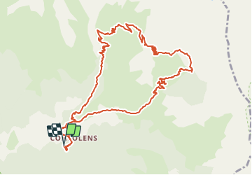
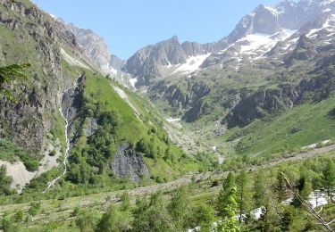
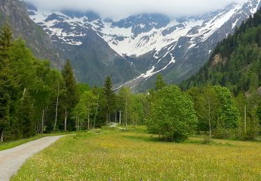
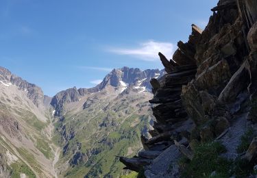
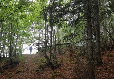
Ruta Carrera de 14,7 km a descubrir en Auvergne-Rhône-Alpes, Isère, Chantepérier. Esta ruta ha sido propuesta por tracegps.
Descripción
Un parcours magnifique. En automne, de nombreux chamois se regroupent dans ce secteur. A vos appareils photos!
Localización
País:
France
Región :
Auvergne-Rhône-Alpes
Departamento/provincia :
Isère
Municipio :
Chantepérier
Localidad:
Unknown
Salida:(Dec)
Salida:(UTM)
736321 ; 4980678 (31T) N.
Comentarios
Excursiones cerca
![Excursión Esquí de fondo Chantepérier - Sommet des Clottous. - Photo](https://media.geolcdn.com/t/375/260/e6bae7aa-c5e9-4420-b059-99bb6ee348f4.jpg&format=jpg&maxdim=2)
![Esquí de fondo Esquí de fondo](https://static1.geolcdn.com/sitytour/trail-icons/503.png)
Sommet des Clottous.
Esquí de fondo
Medio
Chantepérier,
Auvergne-Rhône-Alpes,
Isère,
France
![](/images/other/stat-length.png)
9,4 km | 25 km-effort
4h 49min
![](https://static1.geolcdn.com/siteimages/upload/files/16400158638029165_repeat_loop_refresh_sync_direction_icon.png)
Sí
![Excursión Senderismo Valjouffrey - Valbonnais - Valsenestre - 6.3km 340m 2h10 - 2018 06 21 - public - Photo](https://media.geolcdn.com/t/375/260/ext.jpg?maxdim=2&url=https%3A%2F%2Fservices.sitytrail.com%2FGeolivesWS%2FDownloadMedia.ashx%3FTrailID%3D999388%26Media%3Dfix__20180621125608.jpg)
![Senderismo Senderismo](https://static1.geolcdn.com/sitytour/trail-icons/101.png)
Valbonnais - Valsenestre - 6.3km 340m 2h10 - 2018 06 21 - public
Senderismo
Medio
Valjouffrey,
Auvergne-Rhône-Alpes,
Isère,
France
![](/images/other/stat-length.png)
6,3 km | 10,9 km-effort
2h 40min
![](https://static1.geolcdn.com/siteimages/upload/files/16400158638029165_repeat_loop_refresh_sync_direction_icon.png)
Sí
![Excursión Senderismo Valjouffrey - Valbonnais Valsenestre 2 (Est) - Photo](https://media.geolcdn.com/t/375/260/ext.jpg?maxdim=2&url=https%3A%2F%2Fservices.sitytrail.com%2FGeolivesWS%2FDownloadMedia.ashx%3FTrailID%3D310176%26Media%3Dfix__20140607110505.jpg)
![Senderismo Senderismo](https://static1.geolcdn.com/sitytour/trail-icons/101.png)
Valbonnais Valsenestre 2 (Est)
Senderismo
Medio
Valjouffrey,
Auvergne-Rhône-Alpes,
Isère,
France
![](/images/other/stat-length.png)
11,7 km | 21 km-effort
4h 0min
![](https://static1.geolcdn.com/siteimages/upload/files/16400158638029165_repeat_loop_refresh_sync_direction_icon.png)
Sí
![Excursión Senderismo Valjouffrey - Valbonnais Valsenestre - Photo](https://media.geolcdn.com/t/375/260/ext.jpg?maxdim=2&url=https%3A%2F%2Fservices.sitytrail.com%2FGeolivesWS%2FDownloadMedia.ashx%3FTrailID%3D308954%26Media%3Dfix__20140603181458.jpg)
![Senderismo Senderismo](https://static1.geolcdn.com/sitytour/trail-icons/101.png)
Valbonnais Valsenestre
Senderismo
Fácil
(1)
Valjouffrey,
Auvergne-Rhône-Alpes,
Isère,
France
![](/images/other/stat-length.png)
7,3 km | 10,1 km-effort
2h 20min
![](https://static1.geolcdn.com/siteimages/upload/files/16400158638029165_repeat_loop_refresh_sync_direction_icon.png)
Sí
![Excursión Senderismo Chantepérier - boucle départ le perier - Photo](https://media.geolcdn.com/t/375/260/f8464621-47d2-476f-9597-43e7568bb454.jpg&format=jpg&maxdim=2)
![Senderismo Senderismo](https://static1.geolcdn.com/sitytour/trail-icons/101.png)
boucle départ le perier
Senderismo
Muy difícil
Chantepérier,
Auvergne-Rhône-Alpes,
Isère,
France
![](/images/other/stat-length.png)
10,8 km | 21 km-effort
3h 32min
![](https://static1.geolcdn.com/siteimages/upload/files/16400158638029165_repeat_loop_refresh_sync_direction_icon.png)
Sí
![Excursión Senderismo Valjouffrey - 38 Valbonnais Valsenestre Combe Guyon Lac Labarre Chemin de la Martine - Photo](https://media.geolcdn.com/t/375/260/ext.jpg?maxdim=2&url=https%3A%2F%2Fstatic1.geolcdn.com%2Fsiteimages%2Fupload%2Ffiles%2F1553511878bg_sport_marche.png)
![Senderismo Senderismo](https://static1.geolcdn.com/sitytour/trail-icons/101.png)
38 Valbonnais Valsenestre Combe Guyon Lac Labarre Chemin de la Martine
Senderismo
Muy difícil
(1)
Valjouffrey,
Auvergne-Rhône-Alpes,
Isère,
France
![](/images/other/stat-length.png)
16 km | 34 km-effort
7h 42min
![](https://static1.geolcdn.com/siteimages/upload/files/16400158638029165_repeat_loop_refresh_sync_direction_icon.png)
Sí
![Excursión Senderismo Valjouffrey - 38 Valsenestre au col de Côte Belle - Photo](https://media.geolcdn.com/t/375/260/eefe23cf-bfb1-43cb-97b0-6a0a90d1e415.jpg&format=jpg&maxdim=2)
![Senderismo Senderismo](https://static1.geolcdn.com/sitytour/trail-icons/101.png)
38 Valsenestre au col de Côte Belle
Senderismo
Medio
Valjouffrey,
Auvergne-Rhône-Alpes,
Isère,
France
![](/images/other/stat-length.png)
13,6 km | 27 km-effort
5h 30min
![](https://static1.geolcdn.com/siteimages/upload/files/16400158638029165_repeat_loop_refresh_sync_direction_icon.png)
Sí
![Excursión Senderismo Valjouffrey - Cote Belle et les Orgues du Valsenestre - Photo](https://media.geolcdn.com/t/375/260/0908c75f-3ef0-43fb-81c0-814c3ee186b9.jpg&format=jpg&maxdim=2)
![Senderismo Senderismo](https://static1.geolcdn.com/sitytour/trail-icons/101.png)
Cote Belle et les Orgues du Valsenestre
Senderismo
Difícil
Valjouffrey,
Auvergne-Rhône-Alpes,
Isère,
France
![](/images/other/stat-length.png)
15 km | 31 km-effort
7h 46min
![](https://static1.geolcdn.com/siteimages/upload/files/16400158638029165_repeat_loop_refresh_sync_direction_icon.png)
Sí
![Excursión Senderismo Chantepérier - Circuit de Gaudissart au départ du Périer - Photo](https://media.geolcdn.com/t/375/260/55635fd9-3a90-4b75-89c6-88e1cfea5ad6.jpg&format=jpg&maxdim=2)
![Senderismo Senderismo](https://static1.geolcdn.com/sitytour/trail-icons/101.png)
Circuit de Gaudissart au départ du Périer
Senderismo
Medio
Chantepérier,
Auvergne-Rhône-Alpes,
Isère,
France
![](/images/other/stat-length.png)
10,2 km | 0 m-effort
5h 2min
![](https://static1.geolcdn.com/siteimages/upload/files/16400158638029165_repeat_loop_refresh_sync_direction_icon.png)
Sí