![](/images/other/stat-length.png)
![Excursión Bici de montaña Lamoura - Randonnée VTT - Le Jura de Haut en Bas édition 2009 - Photo](https://media.geolcdn.com/t/1900/400/ext.pjpeg?maxdim=2&url=https%3A%2F%2Fservices.sitytrail.com%2FGeolivesWS%2FDownloadMedia.ashx%3FTrailID%3D103402%26Media%3D5506_1.jpg)
Randonnée VTT - Le Jura de Haut en Bas édition 2009
tracegps
Usuario
![Longitud](/images/other/stat-length.png)
![Altitud máxima](https://static1.geolcdn.com/siteimages/upload/files/1508320355ic_sort_altitude_max_24dp.png)
![Desnivel positivo](https://static1.geolcdn.com/siteimages/upload/files/1508320355ic_sort_den_pos_24dp.png)
![Km-Effort](/images/other/stat-length.png)
![Altitud mínima](https://static1.geolcdn.com/siteimages/upload/files/1508320355ic_sort_altitude_min_24dp.png)
![Desnivel negativo](https://static1.geolcdn.com/siteimages/upload/files/1508320355ic_sort_den_neg_24dp.png)
![Boucle](https://static1.geolcdn.com/siteimages/upload/files/16400158638029165_repeat_loop_refresh_sync_direction_icon.png)
![Bici de montaña](https://static1.geolcdn.com/sitytour/trail-icons/202.png)
7h00
Dificultad : Muy difícil
![Escanee este código QR para abrir la excursión en la aplicación SityTrail](https://capi.geolives.com/qq0zvz2zws4bq2lad0pu/sitytour/trails/103402/qr.png?size=200)
Aplicación GPS de excursión GRATIS
A propósito
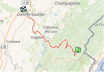
Ruta Bici de montaña de 99 km a descubrir en Borgoña-Franco Condado, Jura, Lamoura. Esta ruta ha sido propuesta por tracegps.
Descripción
Randonnée VTT - Le Jura de Haut en Bas édition 2009 Cette traditionnelle randonnée sans esprit de compétition et ouverte à tous, dont le succès ne se dément pas après déjà 13éditions, permet de découvrir dans une ambiance chaleureuse et festive les paysages et le patrimoine jurassien entre LAMOURA et LONS LE SAUNIER. Sur cet itinéraire entièrement balisé et fléché d'une centaine de kilomètres, 3 points de départ intermédiaires sont proposés pour permettre à chacun d'adapter son parcours à sa condition physique du moment : Château des Prés (75km), Meussia (50km) et Dompierre sur Mont (25km). Des ravitaillements bien garnis jalonneront le parcours jusqu'à Lons le Saunier, point d'arrivée commun à tous les participants. Toutes les infos sur le site de la Section cyclotourisme de l'Amicale Laïque Lédonienne.
Localización
Comentarios
Excursiones cerca
![Excursión Senderismo Septmoncel les Molunes - circuit des chamois Septmoncel - Photo](https://media.geolcdn.com/t/375/260/ext.jpg?maxdim=2&url=https%3A%2F%2Fservices.sitytrail.com%2FGeolivesWS%2FDownloadMedia.ashx%3FTrailID%3D799248%26Media%3D20170730174922.jpg)
![Senderismo Senderismo](https://static1.geolcdn.com/sitytour/trail-icons/101.png)
Senderismo
![](/images/other/stat-length.png)
![](https://static1.geolcdn.com/siteimages/upload/files/16400158638029165_repeat_loop_refresh_sync_direction_icon.png)
![Excursión Senderismo Lamoura - Tresberruy - Lamoura - Photo](https://media.geolcdn.com/t/375/260/ext.jpg?maxdim=2&url=https%3A%2F%2Fservices.sitytrail.com%2FGeolivesWS%2FDownloadMedia.ashx%3FTrailID%3D191503%26Media%3D15097_5.jpg)
![Senderismo Senderismo](https://static1.geolcdn.com/sitytour/trail-icons/101.png)
Senderismo
![](/images/other/stat-length.png)
![](https://static1.geolcdn.com/siteimages/upload/files/16400158638029165_repeat_loop_refresh_sync_direction_icon.png)
![Excursión Senderismo Septmoncel les Molunes - mo sentier des lapidaires - Photo](https://media.geolcdn.com/t/375/260/3ce9e642-8b27-4197-a9db-76cbf671243e.jpg&format=jpg&maxdim=2)
![Senderismo Senderismo](https://static1.geolcdn.com/sitytour/trail-icons/101.png)
Senderismo
![](/images/other/stat-length.png)
![](https://static1.geolcdn.com/siteimages/upload/files/16400158638029165_repeat_loop_refresh_sync_direction_icon.png)
![Excursión Bicicleta Lajoux - 2023-08-18_15h23m20_lamoura - Photo](https://media.geolcdn.com/t/375/260/ext.jpg?maxdim=2&url=https%3A%2F%2Fstatic1.geolcdn.com%2Fsiteimages%2Fupload%2Ffiles%2F1524743154velo.jpg)
![Bicicleta Bicicleta](https://static1.geolcdn.com/sitytour/trail-icons/200.png)
Bicicleta
![](/images/other/stat-length.png)
![](https://static1.geolcdn.com/siteimages/upload/files/16400158638029165_repeat_loop_refresh_sync_direction_icon.png)
![Excursión Carrera Mijoux - UTTJ 2015-2 - Photo](https://media.geolcdn.com/t/375/260/ext.jpg?maxdim=2&url=https%3A%2F%2Fstatic1.geolcdn.com%2Fsiteimages%2Fupload%2Ffiles%2F1524743154running.jpg)
![Carrera Carrera](https://static1.geolcdn.com/sitytour/trail-icons/103.png)
Carrera
![](/images/other/stat-length.png)
![](https://static1.geolcdn.com/siteimages/upload/files/16400158638029165_repeat_loop_refresh_sync_direction_icon.png)
![Excursión Senderismo Lamoura - lamoura neige et plein air - Photo](https://media.geolcdn.com/t/375/260/79eb4e53-0429-41e7-9bcb-cf15e9d8ead1.jpg&format=jpg&maxdim=2)
![Senderismo Senderismo](https://static1.geolcdn.com/sitytour/trail-icons/101.png)
Senderismo
![](/images/other/stat-length.png)
![](https://static1.geolcdn.com/siteimages/upload/files/16400158638029165_repeat_loop_refresh_sync_direction_icon.png)
![Excursión Senderismo Lamoura - neige et plein air lamoura - Photo](https://media.geolcdn.com/t/375/260/0b5e943d-bb9b-41cd-9490-d26e61edcd49.jpg&format=jpg&maxdim=2)
![Senderismo Senderismo](https://static1.geolcdn.com/sitytour/trail-icons/101.png)
Senderismo
![](/images/other/stat-length.png)
![](https://static1.geolcdn.com/siteimages/upload/files/16400158638029165_repeat_loop_refresh_sync_direction_icon.png)
![Excursión Senderismo Lajoux - Le crêt de la vigoureuse (le vrai) - Photo](https://media.geolcdn.com/t/375/260/5ee095a6-7dfc-4756-a886-0e730cf92336.jpg&format=jpg&maxdim=2)
![Senderismo Senderismo](https://static1.geolcdn.com/sitytour/trail-icons/101.png)
Senderismo
![](/images/other/stat-length.png)
![](https://static1.geolcdn.com/siteimages/upload/files/16400158638029165_repeat_loop_refresh_sync_direction_icon.png)
![Excursión Senderismo Lajoux - crêt vigoureuse - Photo](https://media.geolcdn.com/t/375/260/621ceada-b70a-4736-ab71-b2ed77e63872.jpg&format=jpg&maxdim=2)
![Senderismo Senderismo](https://static1.geolcdn.com/sitytour/trail-icons/101.png)
Senderismo
![](/images/other/stat-length.png)
![](https://static1.geolcdn.com/siteimages/upload/files/16400158638029165_repeat_loop_refresh_sync_direction_icon.png)