![](/images/other/stat-length.png)
![Excursión Bici de montaña Vesc - Au pays de Dieulefit - Photo](https://media.geolcdn.com/t/1900/400/ext.pjpeg?maxdim=2&url=https%3A%2F%2Fservices.sitytrail.com%2FGeolivesWS%2FDownloadMedia.ashx%3FTrailID%3D103163%26Media%3D4980_4.jpg)
Au pays de Dieulefit
tracegps
Usuario
![Longitud](/images/other/stat-length.png)
![Altitud máxima](https://static1.geolcdn.com/siteimages/upload/files/1508320355ic_sort_altitude_max_24dp.png)
![Desnivel positivo](https://static1.geolcdn.com/siteimages/upload/files/1508320355ic_sort_den_pos_24dp.png)
![Km-Effort](/images/other/stat-length.png)
![Altitud mínima](https://static1.geolcdn.com/siteimages/upload/files/1508320355ic_sort_altitude_min_24dp.png)
![Desnivel negativo](https://static1.geolcdn.com/siteimages/upload/files/1508320355ic_sort_den_neg_24dp.png)
![Boucle](https://static1.geolcdn.com/siteimages/upload/files/16400158638029165_repeat_loop_refresh_sync_direction_icon.png)
![Bici de montaña](https://static1.geolcdn.com/sitytour/trail-icons/202.png)
2h00
Dificultad : Muy difícil
![Escanee este código QR para abrir la excursión en la aplicación SityTrail](https://capi.geolives.com/qq0zvz2zws4bq2lad0pu/sitytour/trails/103163/qr.png?size=200)
Aplicación GPS de excursión GRATIS
A propósito
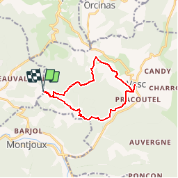
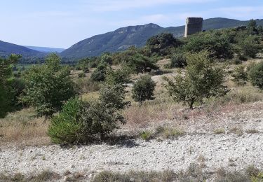
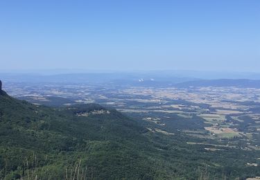
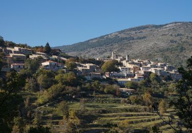
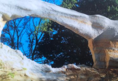
Ruta Bici de montaña de 11,7 km a descubrir en Auvergne-Rhône-Alpes, Drôme, Vesc. Esta ruta ha sido propuesta por tracegps.
Descripción
Un parcours Dieulefit Vesc entre chemins et sentiers facile sauf après le col de Mazelle où la descente s'avère difficile par sa déclivité à mi parcours. Belle balade à faire quand la lavande est en fleurs. Visitez le village de Vesc où vous trouverez un bar près de la fontaine. C'est une rando casse-croûte, plus de détails au gîte du Pré bossu.
Localización
Comentarios
Excursiones cerca
![Excursión Senderismo Montjoux - Le Devès - Montjoux - Photo](https://media.geolcdn.com/t/375/260/ext.jpg?maxdim=2&url=https%3A%2F%2Fservices.sitytrail.com%2FGeolivesWS%2FDownloadMedia.ashx%3FTrailID%3D172804%26Media%3D14234_5.jpg)
![Senderismo Senderismo](https://static1.geolcdn.com/sitytour/trail-icons/101.png)
Senderismo
![](/images/other/stat-length.png)
![](https://static1.geolcdn.com/siteimages/upload/files/16400158638029165_repeat_loop_refresh_sync_direction_icon.png)
![Excursión Senderismo Dieulefit - 26 dieulefit chap st Maurice vitrouilleres - Photo](https://media.geolcdn.com/t/375/260/9032ba92-359b-417c-8863-3a326ab807ba.jpg&format=jpg&maxdim=2)
![Senderismo Senderismo](https://static1.geolcdn.com/sitytour/trail-icons/101.png)
Senderismo
![](/images/other/stat-length.png)
![](https://static1.geolcdn.com/siteimages/upload/files/16400158638029165_repeat_loop_refresh_sync_direction_icon.png)
![Excursión Senderismo Montjoux - 2022-12-16_08h52m12_tmpWriteApidae_48958_fr - Photo](https://media.geolcdn.com/t/375/260/cbc34adf-c509-4a94-9b7f-6317c0990136.jpg&format=jpg&maxdim=2)
![Senderismo Senderismo](https://static1.geolcdn.com/sitytour/trail-icons/101.png)
Senderismo
![](/images/other/stat-length.png)
![](https://static1.geolcdn.com/siteimages/upload/files/16400158638029165_repeat_loop_refresh_sync_direction_icon.png)
![Excursión Senderismo Dieulefit - 2022-09-03_11h50m30_Chapelle St Maurice 10km.gpx (3).xml - Photo](https://media.geolcdn.com/t/375/260/70a2cb51-e6fc-4007-ba36-e4a050e05f72.jpg&format=jpg&maxdim=2)
![Senderismo Senderismo](https://static1.geolcdn.com/sitytour/trail-icons/101.png)
Senderismo
![](/images/other/stat-length.png)
![](https://static1.geolcdn.com/siteimages/upload/files/16400158638029165_repeat_loop_refresh_sync_direction_icon.png)
![Excursión Senderismo Roche-Saint-Secret-Béconne - 26montjoux - Photo](https://media.geolcdn.com/t/375/260/a6833288-f9f8-48b3-afa2-e10324484402.jpg&format=jpg&maxdim=2)
![Senderismo Senderismo](https://static1.geolcdn.com/sitytour/trail-icons/101.png)
Senderismo
![](/images/other/stat-length.png)
![](https://static1.geolcdn.com/siteimages/upload/files/16400158638029165_repeat_loop_refresh_sync_direction_icon.png)
![Excursión Senderismo Roche-Saint-Secret-Béconne - Rachas par Roche Saint-Secret - Photo](https://media.geolcdn.com/t/375/260/363de164-439a-4b5a-97f1-30648b59a904.jpg&format=jpg&maxdim=2)
![Senderismo Senderismo](https://static1.geolcdn.com/sitytour/trail-icons/101.png)
Senderismo
![](/images/other/stat-length.png)
![](https://static1.geolcdn.com/siteimages/upload/files/16400158638029165_repeat_loop_refresh_sync_direction_icon.png)
![Excursión Senderismo Dieulefit - Chapelle saint Maurice par le sentier du cochon - Photo](https://media.geolcdn.com/t/375/260/cf0b1613-8f56-44df-807b-db512561a354.jpg&format=jpg&maxdim=2)
![Senderismo Senderismo](https://static1.geolcdn.com/sitytour/trail-icons/101.png)
Senderismo
![](/images/other/stat-length.png)
![](https://static1.geolcdn.com/siteimages/upload/files/16400158638029165_repeat_loop_refresh_sync_direction_icon.png)
![Excursión Senderismo Comps - 2024-03-07_12h38m09_Orcinas 14km - Photo](https://media.geolcdn.com/t/375/260/d29c1d85-ffea-4497-9bab-1cce45a06780.jpg&format=jpg&maxdim=2)
![Senderismo Senderismo](https://static1.geolcdn.com/sitytour/trail-icons/101.png)
Senderismo
![](/images/other/stat-length.png)
![](https://static1.geolcdn.com/siteimages/upload/files/16400158638029165_repeat_loop_refresh_sync_direction_icon.png)
![Excursión Senderismo Dieulefit - Vitrouillières Dieulefit - Photo](https://media.geolcdn.com/t/375/260/11bc24d8-15a9-487b-bcda-b3a093eafbe9.jpg&format=jpg&maxdim=2)
![Senderismo Senderismo](https://static1.geolcdn.com/sitytour/trail-icons/101.png)
Senderismo
![](/images/other/stat-length.png)
![](https://static1.geolcdn.com/siteimages/upload/files/16400158638029165_repeat_loop_refresh_sync_direction_icon.png)