![](/images/other/stat-length.png)
![Excursión Raquetas de nieve Anglefort - La Croix du Colombier 1525m depuis Bezonne - Photo](https://media.geolcdn.com/t/1900/400/ext.pjpeg?maxdim=2&url=https%3A%2F%2Fservices.sitytrail.com%2FGeolivesWS%2FDownloadMedia.ashx%3FTrailID%3D103064%26Media%3D4699_1.jpg)
La Croix du Colombier 1525m depuis Bezonne
tracegps
Usuario
![Longitud](/images/other/stat-length.png)
![Altitud máxima](https://static1.geolcdn.com/siteimages/upload/files/1508320355ic_sort_altitude_max_24dp.png)
![Desnivel positivo](https://static1.geolcdn.com/siteimages/upload/files/1508320355ic_sort_den_pos_24dp.png)
![Km-Effort](/images/other/stat-length.png)
![Altitud mínima](https://static1.geolcdn.com/siteimages/upload/files/1508320355ic_sort_altitude_min_24dp.png)
![Desnivel negativo](https://static1.geolcdn.com/siteimages/upload/files/1508320355ic_sort_den_neg_24dp.png)
![Boucle](https://static1.geolcdn.com/siteimages/upload/files/16400158638029165_repeat_loop_refresh_sync_direction_icon.png)
![Raquetas de nieve](https://static1.geolcdn.com/sitytour/trail-icons/504.png)
4h30
Dificultad : Medio
![Escanee este código QR para abrir la excursión en la aplicación SityTrail](https://capi.geolives.com/qq0zvz2zws4bq2lad0pu/sitytour/trails/103064/qr.png?size=200)
Aplicación GPS de excursión GRATIS
A propósito
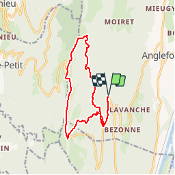
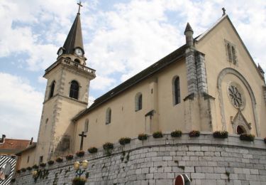
Ruta Raquetas de nieve de 14,2 km a descubrir en Auvergne-Rhône-Alpes, Ain, Anglefort. Esta ruta ha sido propuesta por tracegps.
Descripción
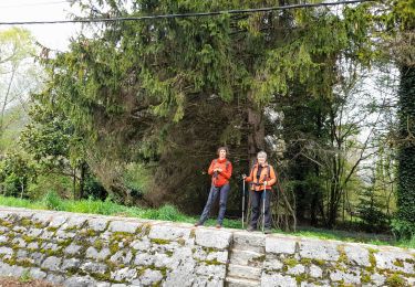
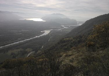
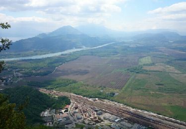
Randonnée en raquettes. L'itinéraire parcourt le versant Est du Grand Colombier depuis Bezonne au dessus d'Anglefort. L'arête Nord depuis le Col de Charbemènes, atteint par les Granges de Scioux et le Pré Veyrand, donne accès à la Croix et la table d'orientation du Grand Colombier. La descente facile de la route enneigée mène à Longechat pour parcourir des espaces sauvages peu fréquentés à travers les Prés Révèle et le Grand Creux pour rejoindre le départ par les Granges de Bezonne. Description complète sur sentier-nature.com : La Croix du Colombier 1525m depuis Bezonne Avertissement : En randonnée, à pieds ou en raquettes, pour ne pas s'égarer à travers un paysage enneigé, carte 1/25000e, boussole et altimètre sont très utiles, surtout par temps de brouillard. La randonnée en montagne l'hiver, à pieds, en raquettes, à ski est une activité dangereuse qui nécessite une grande autonomie et l'acceptation d'un degré de risque adapté aux capacités de chacun. Prendre connaissance du terrain, des conditions météorologiques et des risques d'avalanches est nécessaire avant de partir.
Localización
Comentarios
Excursiones cerca
![Excursión Senderismo Béon - Pierre chandruraz. - Photo](https://media.geolcdn.com/t/375/260/074e1b1a-8d87-46da-8de1-124fb8fd4758.jpg&format=jpg&maxdim=2)
![Senderismo Senderismo](https://static1.geolcdn.com/sitytour/trail-icons/101.png)
Senderismo
![](/images/other/stat-length.png)
![](https://static1.geolcdn.com/siteimages/upload/files/16400158638029165_repeat_loop_refresh_sync_direction_icon.png)
![Excursión sport Culoz - Fenestre - Photo](https://media.geolcdn.com/t/375/260/1a8b0045-a978-442c-8ec1-037d85e229c2.jpg&format=jpg&maxdim=2)
sport
![](/images/other/stat-length.png)
![](https://static1.geolcdn.com/siteimages/upload/files/16400158638029165_repeat_loop_refresh_sync_direction_icon.png)
![Excursión Senderismo Motz - MOTZ SERRIERES: BORDS DU RHONE - Photo](https://media.geolcdn.com/t/375/260/d5979f91-e62c-40fa-96a4-fc46ef5f42b9.jpg&format=jpg&maxdim=2)
![Senderismo Senderismo](https://static1.geolcdn.com/sitytour/trail-icons/101.png)
Senderismo
![](/images/other/stat-length.png)
![](https://static1.geolcdn.com/siteimages/upload/files/16400158638029165_repeat_loop_refresh_sync_direction_icon.png)
![Excursión Senderismo Arvière-en-Valromey - GR 9 - Étape 13 - Chalet d’Arvières - Chanaz - Photo](https://media.geolcdn.com/t/375/260/e124169d-20c4-4d49-b21c-03de29e41215.jpg&format=jpg&maxdim=2)
![Senderismo Senderismo](https://static1.geolcdn.com/sitytour/trail-icons/101.png)
Senderismo
![](/images/other/stat-length.png)
![](https://static1.geolcdn.com/siteimages/upload/files/16400158638029165_repeat_loop_refresh_sync_direction_icon.png)
![Excursión Senderismo Anglefort - les sarrasins - Photo](https://media.geolcdn.com/t/375/260/ext.jpg?maxdim=2&url=https%3A%2F%2Fservices.sitytrail.com%2FGeolivesWS%2FDownloadMedia.ashx%3FTrailID%3D853181%26Media%3Dfix__20171025122448.jpg)
![Senderismo Senderismo](https://static1.geolcdn.com/sitytour/trail-icons/101.png)
Senderismo
![](/images/other/stat-length.png)
![](https://static1.geolcdn.com/siteimages/upload/files/16400158638029165_repeat_loop_refresh_sync_direction_icon.png)
![Excursión Senderismo Béon - Roche percée - Photo](https://media.geolcdn.com/t/375/260/ext.jpg?maxdim=2&url=https%3A%2F%2Fservices.sitytrail.com%2FGeolivesWS%2FDownloadMedia.ashx%3FTrailID%3D273975%26Media%3Dfix__20140504124416.jpg)
![Senderismo Senderismo](https://static1.geolcdn.com/sitytour/trail-icons/101.png)
Senderismo
![](/images/other/stat-length.png)
![](https://static1.geolcdn.com/siteimages/upload/files/16400158638029165_repeat_loop_refresh_sync_direction_icon.png)
![Excursión Senderismo Serrières-en-Chautagne - Sur les Pas des Huguenots - Serrières en Chautagne - Seyssel - Photo](https://media.geolcdn.com/t/375/260/ext.jpg?maxdim=2&url=https%3A%2F%2Fservices.sitytrail.com%2FGeolivesWS%2FDownloadMedia.ashx%3FTrailID%3D129672%26Media%3D13204_5.jpg)
![Senderismo Senderismo](https://static1.geolcdn.com/sitytour/trail-icons/101.png)
Senderismo
![](/images/other/stat-length.png)
![](https://static1.geolcdn.com/siteimages/upload/files/16400158638029165_repeat_loop_refresh_sync_direction_icon.png)
![Excursión Senderismo Arvière-en-Valromey - GTJ 13 Chalet d'Arviere/Culoz - Photo](https://media.geolcdn.com/t/375/260/95e569a8-40e4-4cb8-99dd-166dae94e18d.jpg&format=jpg&maxdim=2)
![Senderismo Senderismo](https://static1.geolcdn.com/sitytour/trail-icons/101.png)
Senderismo
![](/images/other/stat-length.png)
![](https://static1.geolcdn.com/siteimages/upload/files/16400158638029165_repeat_loop_refresh_sync_direction_icon.png)
![Excursión Senderismo Motz - Sentier Ornithologique du Fier - Photo](https://media.geolcdn.com/t/375/260/d4005703-68e3-471d-8360-fc8093f0f4a3.jpg&format=jpg&maxdim=2)
![Senderismo Senderismo](https://static1.geolcdn.com/sitytour/trail-icons/101.png)
Senderismo
![](/images/other/stat-length.png)
![](https://static1.geolcdn.com/siteimages/upload/files/16400158638029165_repeat_loop_refresh_sync_direction_icon.png)