![](/images/other/stat-length.png)
![Excursión Senderismo Assat - Bois d'Assat - Photo](https://media.geolcdn.com/t/1900/400/ext.pjpeg?maxdim=2&url=https%3A%2F%2Fservices.sitytrail.com%2FGeolivesWS%2FDownloadMedia.ashx%3FTrailID%3D103063%26Media%3D4698_1.jpg)
Bois d'Assat
tracegps
Usuario
![Longitud](/images/other/stat-length.png)
![Altitud máxima](https://static1.geolcdn.com/siteimages/upload/files/1508320355ic_sort_altitude_max_24dp.png)
![Desnivel positivo](https://static1.geolcdn.com/siteimages/upload/files/1508320355ic_sort_den_pos_24dp.png)
![Km-Effort](/images/other/stat-length.png)
![Altitud mínima](https://static1.geolcdn.com/siteimages/upload/files/1508320355ic_sort_altitude_min_24dp.png)
![Desnivel negativo](https://static1.geolcdn.com/siteimages/upload/files/1508320355ic_sort_den_neg_24dp.png)
![Boucle](https://static1.geolcdn.com/siteimages/upload/files/16400158638029165_repeat_loop_refresh_sync_direction_icon.png)
![Senderismo](https://static1.geolcdn.com/sitytour/trail-icons/101.png)
1h30
Dificultad : Medio
![Escanee este código QR para abrir la excursión en la aplicación SityTrail](https://capi.geolives.com/qq0zvz2zws4bq2lad0pu/sitytour/trails/103063/qr.png?size=200)
Aplicación GPS de excursión GRATIS
A propósito
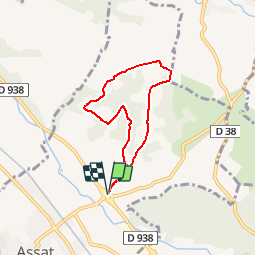
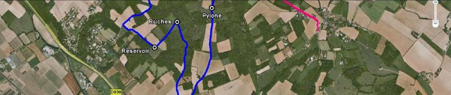
Ruta Senderismo de 5,9 km a descubrir en Nueva Aquitania, Pirineos-Atlánticos, Assat. Esta ruta ha sido propuesta por tracegps.
Descripción
Belvédère praticable en toute saison, avec une très belle vue sur la chaîne des Pyrénées. Seule difficulté : une montée un peu raide en début de circuit. Pour s'y rendre en voiture, prendre la D938 entre Pau et Nay et se garer au niveau de la bretelle de sortie vers Assat, en contrebas du pont.
Localización
Comentarios
Excursiones cerca
![Excursión Senderismo Rontignon - Coteaux de Rontignon - Photo](https://media.geolcdn.com/t/375/260/ext.jpg?maxdim=2&url=https%3A%2F%2Fservices.sitytrail.com%2FGeolivesWS%2FDownloadMedia.ashx%3FTrailID%3D103073%26Media%3D4763_4.jpg)
![Senderismo Senderismo](https://static1.geolcdn.com/sitytour/trail-icons/101.png)
Senderismo
![](/images/other/stat-length.png)
![](https://static1.geolcdn.com/siteimages/upload/files/16400158638029165_repeat_loop_refresh_sync_direction_icon.png)
![Excursión Senderismo Assat - BALISAGE GR 782 OUSSE / PONT DU14 JUILLET le 4/04/2023](https://media.geolcdn.com/t/375/260/eb1c9c16-be7e-4360-bd65-bc0bfd1108bb.jpg&format=jpg&maxdim=2)
![Senderismo Senderismo](https://static1.geolcdn.com/sitytour/trail-icons/101.png)
Senderismo
![](/images/other/stat-length.png)
![](https://static1.geolcdn.com/siteimages/upload/files/16400158638029165_repeat_loop_refresh_sync_direction_icon.png)
![Excursión Senderismo Bizanos - BIZANOS RANDONNÉE PATRIMOINE 2868740 - Photo](https://media.geolcdn.com/t/375/260/213837b0-04be-4f10-8a02-95ffa46e349c.jpg&format=jpg&maxdim=2)
![Senderismo Senderismo](https://static1.geolcdn.com/sitytour/trail-icons/101.png)
Senderismo
![](/images/other/stat-length.png)
![](https://static1.geolcdn.com/siteimages/upload/files/16400158638029165_repeat_loop_refresh_sync_direction_icon.png)
![Excursión Senderismo Assat - OUSSE a la rencontre de Cesar M2 - Photo](https://media.geolcdn.com/t/375/260/be0f19de-b432-4b6e-a08d-e17178e1c230.jpg&format=jpg&maxdim=2)
![Senderismo Senderismo](https://static1.geolcdn.com/sitytour/trail-icons/101.png)
Senderismo
![](/images/other/stat-length.png)
![](https://static1.geolcdn.com/siteimages/upload/files/16400158638029165_repeat_loop_refresh_sync_direction_icon.png)
![Excursión Senderismo Rontignon - RONTIGNON le chemin des crêtes M2 fait 2644181 - Photo](https://media.geolcdn.com/t/375/260/797f6c13-d1f6-445b-af12-f454d456b125.jpg&format=jpg&maxdim=2)
![Senderismo Senderismo](https://static1.geolcdn.com/sitytour/trail-icons/101.png)
Senderismo
![](/images/other/stat-length.png)
![](https://static1.geolcdn.com/siteimages/upload/files/16400158638029165_repeat_loop_refresh_sync_direction_icon.png)
![Excursión Senderismo Uzos - UZOS la boucle de la glandee balisee le 29 07 20 - Photo](https://media.geolcdn.com/t/375/260/e45bec67-f808-4c2a-b223-22164fa7db06.jpg&format=jpg&maxdim=2)
![Senderismo Senderismo](https://static1.geolcdn.com/sitytour/trail-icons/101.png)
Senderismo
![](/images/other/stat-length.png)
![](https://static1.geolcdn.com/siteimages/upload/files/16400158638029165_repeat_loop_refresh_sync_direction_icon.png)
![Excursión Senderismo Idron - IDRON Deconfinement seul - Photo](https://media.geolcdn.com/t/375/260/c0185c73-9332-4a95-b3e0-d63027a94adb.jpg&format=jpg&maxdim=2)
![Senderismo Senderismo](https://static1.geolcdn.com/sitytour/trail-icons/101.png)
Senderismo
![](/images/other/stat-length.png)
![](https://static1.geolcdn.com/siteimages/upload/files/16400158638029165_repeat_loop_refresh_sync_direction_icon.png)
![Excursión Senderismo Idron - IDRON confinement 33 eme - Photo](https://media.geolcdn.com/t/375/260/ec2df528-9a3a-4b62-ac63-ea639520db62.jpg&format=jpg&maxdim=2)
![Senderismo Senderismo](https://static1.geolcdn.com/sitytour/trail-icons/101.png)
Senderismo
![](/images/other/stat-length.png)
![](https://static1.geolcdn.com/siteimages/upload/files/16400158638029165_repeat_loop_refresh_sync_direction_icon.png)
![Excursión Senderismo Idron - IDRON confinement (32eme) - Photo](https://media.geolcdn.com/t/375/260/6669185c-9d5a-4b54-9cbb-9f4ce8afc53a.jpg&format=jpg&maxdim=2)
![Senderismo Senderismo](https://static1.geolcdn.com/sitytour/trail-icons/101.png)
Senderismo
![](/images/other/stat-length.png)
![](https://static1.geolcdn.com/siteimages/upload/files/16400158638029165_repeat_loop_refresh_sync_direction_icon.png)