![](/images/other/stat-length.png)
![Excursión Bici de montaña Annezin - Rando Busnes départ Annezin - Photo](https://media.geolcdn.com/t/1900/400/ext.pjpeg?maxdim=2&url=https%3A%2F%2Fservices.sitytrail.com%2FGeolivesWS%2FDownloadMedia.ashx%3FTrailID%3D102982%26Media%3D4506_1.jpg)
Rando Busnes départ Annezin
tracegps
Usuario
![Longitud](/images/other/stat-length.png)
Longitud
45 km
![Altitud máxima](https://static1.geolcdn.com/siteimages/upload/files/1508320355ic_sort_altitude_max_24dp.png)
Altitud máxima
83 m
![Desnivel positivo](https://static1.geolcdn.com/siteimages/upload/files/1508320355ic_sort_den_pos_24dp.png)
Desnivel positivo
270 m
![Km-Effort](/images/other/stat-length.png)
Km-Effort
49 km
![Altitud mínima](https://static1.geolcdn.com/siteimages/upload/files/1508320355ic_sort_altitude_min_24dp.png)
Altitud mínima
15 m
![Desnivel negativo](https://static1.geolcdn.com/siteimages/upload/files/1508320355ic_sort_den_neg_24dp.png)
Desnivel negativo
269 m
![Boucle](https://static1.geolcdn.com/siteimages/upload/files/16400158638029165_repeat_loop_refresh_sync_direction_icon.png)
Boucle
Sí
Fecha de creación :
2014-12-10 00:00:00.0
Última modificación :
2014-12-10 00:00:00.0
![Bici de montaña](https://static1.geolcdn.com/sitytour/trail-icons/202.png)
3h00
Dificultad : Medio
![Escanee este código QR para abrir la excursión en la aplicación SityTrail](https://capi.geolives.com/qq0zvz2zws4bq2lad0pu/sitytour/trails/102982/qr.png?size=200)
Aplicación GPS de excursión GRATIS
A propósito
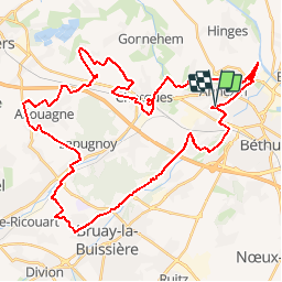
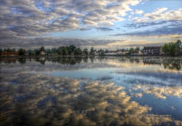
Ruta Bici de montaña de 45 km a descubrir en Alta Francia, Paso de Calais, Annezin. Esta ruta ha sido propuesta por tracegps.
Descripción
Le site Ch’ti GPS. Perds te pas avec mi ! Sympa. Chemin, Foret, Ligne de chemin de fer... Parcours de Busnes modifié Départ sur Annezin...
Localización
País:
France
Región :
Alta Francia
Departamento/provincia :
Paso de Calais
Municipio :
Annezin
Localidad:
Unknown
Salida:(Dec)
Salida:(UTM)
472658 ; 5598183 (31U) N.
Comentarios
Excursiones cerca
![Excursión Senderismo Hinges - Le Rietz - Hinges - Photo](https://media.geolcdn.com/t/375/260/ext.jpg?maxdim=2&url=https%3A%2F%2Fservices.sitytrail.com%2FGeolivesWS%2FDownloadMedia.ashx%3FTrailID%3D110214%26Media%3D5469_6.jpg)
![Senderismo Senderismo](https://static1.geolcdn.com/sitytour/trail-icons/101.png)
Le Rietz - Hinges
Senderismo
Medio
(3)
Hinges,
Alta Francia,
Paso de Calais,
France
![](/images/other/stat-length.png)
12,3 km | 13,4 km-effort
3h 0min
![](https://static1.geolcdn.com/siteimages/upload/files/16400158638029165_repeat_loop_refresh_sync_direction_icon.png)
Sí
![Excursión Senderismo Béthune - Le sentier de Catorive. - Béthune - Photo](https://media.geolcdn.com/t/375/260/ext.jpg?maxdim=2&url=https%3A%2F%2Fservices.sitytrail.com%2FGeolivesWS%2FDownloadMedia.ashx%3FTrailID%3D110213%26Media%3D5468_6.jpg)
![Senderismo Senderismo](https://static1.geolcdn.com/sitytour/trail-icons/101.png)
Le sentier de Catorive. - Béthune
Senderismo
Medio
(2)
Béthune,
Alta Francia,
Paso de Calais,
France
![](/images/other/stat-length.png)
8,3 km | 9 km-effort
2h 0min
![](https://static1.geolcdn.com/siteimages/upload/files/16400158638029165_repeat_loop_refresh_sync_direction_icon.png)
Sí
![Excursión Senderismo Labourse - randonnée labourse - Photo](https://media.geolcdn.com/t/375/260/1a0715d7-ae08-418a-ae9d-b73bd4292578.jpg&format=jpg&maxdim=2)
![Senderismo Senderismo](https://static1.geolcdn.com/sitytour/trail-icons/101.png)
randonnée labourse
Senderismo
Muy difícil
Labourse,
Alta Francia,
Paso de Calais,
France
![](/images/other/stat-length.png)
20 km | 22 km-effort
2h 45min
![](https://static1.geolcdn.com/siteimages/upload/files/16400158638029165_repeat_loop_refresh_sync_direction_icon.png)
No
![Excursión Senderismo Béthune - Béthune - Photo](https://media.geolcdn.com/t/375/260/d9061de5-0472-4700-aacc-418536d45e38.jpg&format=jpg&maxdim=2)
![Senderismo Senderismo](https://static1.geolcdn.com/sitytour/trail-icons/101.png)
Béthune
Senderismo
Muy fácil
Béthune,
Alta Francia,
Paso de Calais,
France
![](/images/other/stat-length.png)
5,6 km | 6,2 km-effort
2h 7min
![](https://static1.geolcdn.com/siteimages/upload/files/16400158638029165_repeat_loop_refresh_sync_direction_icon.png)
Sí
![Excursión Senderismo Labourse - Sentier des familles - Labourse - Photo](https://media.geolcdn.com/t/375/260/ext.jpg?maxdim=2&url=https%3A%2F%2Fservices.sitytrail.com%2FGeolivesWS%2FDownloadMedia.ashx%3FTrailID%3D318036%26Media%3D17501_6.jpg)
![Senderismo Senderismo](https://static1.geolcdn.com/sitytour/trail-icons/101.png)
Sentier des familles - Labourse
Senderismo
Fácil
Labourse,
Alta Francia,
Paso de Calais,
France
![](/images/other/stat-length.png)
5,3 km | 5,7 km-effort
1h 19min
![](https://static1.geolcdn.com/siteimages/upload/files/16400158638029165_repeat_loop_refresh_sync_direction_icon.png)
Sí
![Excursión Senderismo Vaudricourt - Sentier des paysages - Vaudricourt - Photo](https://media.geolcdn.com/t/375/260/ext.jpg?maxdim=2&url=https%3A%2F%2Fservices.sitytrail.com%2FGeolivesWS%2FDownloadMedia.ashx%3FTrailID%3D318035%26Media%3D17500_6.jpg)
![Senderismo Senderismo](https://static1.geolcdn.com/sitytour/trail-icons/101.png)
Sentier des paysages - Vaudricourt
Senderismo
Fácil
(2)
Vaudricourt,
Alta Francia,
Paso de Calais,
France
![](/images/other/stat-length.png)
6,4 km | 7 km-effort
1h 34min
![](https://static1.geolcdn.com/siteimages/upload/files/16400158638029165_repeat_loop_refresh_sync_direction_icon.png)
Sí
![Excursión Senderismo Fouquières-lès-Béthune - Le sentier des 2 riviéres - Fouquières lez Béthune - Photo](https://media.geolcdn.com/t/375/260/ext.jpg?maxdim=2&url=https%3A%2F%2Fservices.sitytrail.com%2FGeolivesWS%2FDownloadMedia.ashx%3FTrailID%3D318034%26Media%3D17499_6.jpg)
![Senderismo Senderismo](https://static1.geolcdn.com/sitytour/trail-icons/101.png)
Le sentier des 2 riviéres - Fouquières lez Béthune
Senderismo
Medio
Fouquières-lès-Béthune,
Alta Francia,
Paso de Calais,
France
![](/images/other/stat-length.png)
8,2 km | 8,9 km-effort
2h 4min
![](https://static1.geolcdn.com/siteimages/upload/files/16400158638029165_repeat_loop_refresh_sync_direction_icon.png)
Sí
![Excursión Senderismo Beuvry - Le Marais de Beuvry - Photo](https://media.geolcdn.com/t/375/260/ext.jpg?maxdim=2&url=https%3A%2F%2Fservices.sitytrail.com%2FGeolivesWS%2FDownloadMedia.ashx%3FTrailID%3D317770%26Media%3D17085_6.jpg)
![Senderismo Senderismo](https://static1.geolcdn.com/sitytour/trail-icons/101.png)
Le Marais de Beuvry
Senderismo
Medio
Beuvry,
Alta Francia,
Paso de Calais,
France
![](/images/other/stat-length.png)
12,8 km | 13,8 km-effort
3h 0min
![](https://static1.geolcdn.com/siteimages/upload/files/16400158638029165_repeat_loop_refresh_sync_direction_icon.png)
Sí
![Excursión Bicicleta Beuvry - Autour du beffroi (de Béthune) - Beuvry - Photo](https://media.geolcdn.com/t/375/260/ext.jpg?maxdim=2&url=https%3A%2F%2Fservices.sitytrail.com%2FGeolivesWS%2FDownloadMedia.ashx%3FTrailID%3D316848%26Media%3D15916_5.jpg)
![Bicicleta Bicicleta](https://static1.geolcdn.com/sitytour/trail-icons/200.png)
Autour du beffroi (de Béthune) - Beuvry
Bicicleta
Medio
Beuvry,
Alta Francia,
Paso de Calais,
France
![](/images/other/stat-length.png)
36 km | 39 km-effort
2h 0min
![](https://static1.geolcdn.com/siteimages/upload/files/16400158638029165_repeat_loop_refresh_sync_direction_icon.png)
Sí