![](/images/other/stat-length.png)
![Excursión Senderismo Saint-Georges-de-Rouelley - 9058741-Fosse Arthour -Grille souris - Photo](https://media.geolcdn.com/t/1900/400/ext.pjpeg?maxdim=2&url=https%3A%2F%2Fstatic1.geolcdn.com%2Fsiteimages%2Fupload%2Ffiles%2F1553511878bg_sport_marche.png)
9058741-Fosse Arthour -Grille souris
toporient
Usuario
![Longitud](/images/other/stat-length.png)
Longitud
10,8 km
![Altitud máxima](https://static1.geolcdn.com/siteimages/upload/files/1508320355ic_sort_altitude_max_24dp.png)
Altitud máxima
245 m
![Desnivel positivo](https://static1.geolcdn.com/siteimages/upload/files/1508320355ic_sort_den_pos_24dp.png)
Desnivel positivo
196 m
![Km-Effort](/images/other/stat-length.png)
Km-Effort
13,4 km
![Altitud mínima](https://static1.geolcdn.com/siteimages/upload/files/1508320355ic_sort_altitude_min_24dp.png)
Altitud mínima
161 m
![Desnivel negativo](https://static1.geolcdn.com/siteimages/upload/files/1508320355ic_sort_den_neg_24dp.png)
Desnivel negativo
196 m
![Boucle](https://static1.geolcdn.com/siteimages/upload/files/16400158638029165_repeat_loop_refresh_sync_direction_icon.png)
Boucle
Sí
Fecha de creación :
2019-01-15 15:19:22.15
Última modificación :
2019-06-07 12:56:11.917
![Senderismo](https://static1.geolcdn.com/sitytour/trail-icons/101.png)
2h46
Dificultad : Medio
![Escanee este código QR para abrir la excursión en la aplicación SityTrail](https://capi.geolives.com/qq0zvz2zws4bq2lad0pu/sitytour/trails/1029664/qr.png?size=200)
Aplicación GPS de excursión GRATIS
A propósito
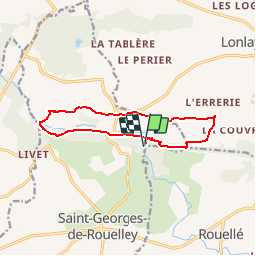
Ruta Senderismo de 10,8 km a descubrir en Normandía, Mancha, Saint-Georges-de-Rouelley. Esta ruta ha sido propuesta por toporient.
Descripción
Départ du parking du site de la Fosse Arthour.
(Attention: Soyez vigilants lors des passages sur routes.)
Localización
País:
France
Región :
Normandía
Departamento/provincia :
Mancha
Municipio :
Saint-Georges-de-Rouelley
Localidad:
Unknown
Salida:(Dec)
Salida:(UTM)
665581 ; 5387890 (30U) N.
Comentarios
Excursiones cerca
![Excursión Bici de montaña Saint-Georges-de-Rouelley - la Fosse Arthour - Photo](https://media.geolcdn.com/t/375/260/ext.jpg?maxdim=2&url=https%3A%2F%2Fservices.sitytrail.com%2FGeolivesWS%2FDownloadMedia.ashx%3FTrailID%3D448888%26Media%3Dfix__20140524121741.jpg)
![Bici de montaña Bici de montaña](https://static1.geolcdn.com/sitytour/trail-icons/202.png)
la Fosse Arthour
Bici de montaña
Difícil
Saint-Georges-de-Rouelley,
Normandía,
Mancha,
France
![](/images/other/stat-length.png)
27 km | 33 km-effort
2h 41min
![](https://static1.geolcdn.com/siteimages/upload/files/16400158638029165_repeat_loop_refresh_sync_direction_icon.png)
Sí
![Excursión Senderismo Saint-Georges-de-Rouelley - La fosse Arthour - Photo](https://media.geolcdn.com/t/375/260/32d61d19-a1a2-440c-bafe-6776853dd015.jpg&format=jpg&maxdim=2)
![Senderismo Senderismo](https://static1.geolcdn.com/sitytour/trail-icons/101.png)
La fosse Arthour
Senderismo
Fácil
Saint-Georges-de-Rouelley,
Normandía,
Mancha,
France
![](/images/other/stat-length.png)
8,7 km | 10,9 km-effort
2h 5min
![](https://static1.geolcdn.com/siteimages/upload/files/16400158638029165_repeat_loop_refresh_sync_direction_icon.png)
Sí
![Excursión Senderismo Saint-Georges-de-Rouelley - Le Moulin Foulon - Saint Georges de Rouelley - Photo](https://media.geolcdn.com/t/375/260/ext.jpg?maxdim=2&url=https%3A%2F%2Fservices.sitytrail.com%2FGeolivesWS%2FDownloadMedia.ashx%3FTrailID%3D111196%26Media%3D6688_1.jpg)
![Senderismo Senderismo](https://static1.geolcdn.com/sitytour/trail-icons/101.png)
Le Moulin Foulon - Saint Georges de Rouelley
Senderismo
Medio
Saint-Georges-de-Rouelley,
Normandía,
Mancha,
France
![](/images/other/stat-length.png)
7,9 km | 10,2 km-effort
2h 0min
![](https://static1.geolcdn.com/siteimages/upload/files/16400158638029165_repeat_loop_refresh_sync_direction_icon.png)
Sí
![Excursión Senderismo Saint-Georges-de-Rouelley - La Fosse Arthour - Photo](https://media.geolcdn.com/t/375/260/ext.jpg?maxdim=2&url=https%3A%2F%2Fservices.sitytrail.com%2FGeolivesWS%2FDownloadMedia.ashx%3FTrailID%3D109292%26Media%3D3494_1.jpg)
![Senderismo Senderismo](https://static1.geolcdn.com/sitytour/trail-icons/101.png)
La Fosse Arthour
Senderismo
Medio
Saint-Georges-de-Rouelley,
Normandía,
Mancha,
France
![](/images/other/stat-length.png)
8 km | 10,7 km-effort
2h 30min
![](https://static1.geolcdn.com/siteimages/upload/files/16400158638029165_repeat_loop_refresh_sync_direction_icon.png)
Sí
![Excursión Senderismo Saint-Georges-de-Rouelley - Sentier Fosse Arthour - Photo](https://media.geolcdn.com/t/375/260/ext.jpg?maxdim=2&url=https%3A%2F%2Fstatic1.geolcdn.com%2Fsiteimages%2Fupload%2Ffiles%2F1553511878bg_sport_marche.png)
![Senderismo Senderismo](https://static1.geolcdn.com/sitytour/trail-icons/101.png)
Sentier Fosse Arthour
Senderismo
Medio
Saint-Georges-de-Rouelley,
Normandía,
Mancha,
France
![](/images/other/stat-length.png)
6,2 km | 7,7 km-effort
1h 45min
![](https://static1.geolcdn.com/siteimages/upload/files/16400158638029165_repeat_loop_refresh_sync_direction_icon.png)
Sí
![Excursión Senderismo Saint-Georges-de-Rouelley - autour de la fosse Arthour - Photo](https://media.geolcdn.com/t/375/260/a82fc14a-159c-4e45-9604-d0f35396c2a2.jpg&format=jpg&maxdim=2)
![Senderismo Senderismo](https://static1.geolcdn.com/sitytour/trail-icons/101.png)
autour de la fosse Arthour
Senderismo
Fácil
Saint-Georges-de-Rouelley,
Normandía,
Mancha,
France
![](/images/other/stat-length.png)
11,3 km | 14 km-effort
2h 13min
![](https://static1.geolcdn.com/siteimages/upload/files/16400158638029165_repeat_loop_refresh_sync_direction_icon.png)
Sí
![Excursión Senderismo Saint-Georges-de-Rouelley - randonnée la Fosse Arthour / Mortain par le GR 22 - Photo](https://media.geolcdn.com/t/375/260/ext.jpg?maxdim=2&url=https%3A%2F%2Fstatic1.geolcdn.com%2Fsiteimages%2Fupload%2Ffiles%2F1553511878bg_sport_marche.png)
![Senderismo Senderismo](https://static1.geolcdn.com/sitytour/trail-icons/101.png)
randonnée la Fosse Arthour / Mortain par le GR 22
Senderismo
Medio
Saint-Georges-de-Rouelley,
Normandía,
Mancha,
France
![](/images/other/stat-length.png)
24 km | 31 km-effort
5h 23min
![](https://static1.geolcdn.com/siteimages/upload/files/16400158638029165_repeat_loop_refresh_sync_direction_icon.png)
No
![Excursión Cicloturismo Domfront en Poiraie - SityTrail - Mayenne domfront - Photo](https://media.geolcdn.com/t/375/260/ext.jpg?maxdim=2&url=https%3A%2F%2Fstatic1.geolcdn.com%2Fsiteimages%2Fupload%2Ffiles%2F1524743154velo.jpg)
![Cicloturismo Cicloturismo](https://static1.geolcdn.com/sitytour/trail-icons/204.png)
SityTrail - Mayenne domfront
Cicloturismo
Medio
Domfront en Poiraie,
Normandía,
Orne,
France
![](/images/other/stat-length.png)
52 km | 58 km-effort
Desconocido
![](https://static1.geolcdn.com/siteimages/upload/files/16400158638029165_repeat_loop_refresh_sync_direction_icon.png)
No
![Excursión Senderismo Lonlay-l'Abbaye - Randonnée Mont Saint Michel partie 2 - Photo](https://media.geolcdn.com/t/375/260/ext.jpg?maxdim=2&url=https%3A%2F%2Fstatic1.geolcdn.com%2Fsiteimages%2Fupload%2Ffiles%2F1553511878bg_sport_marche.png)
![Senderismo Senderismo](https://static1.geolcdn.com/sitytour/trail-icons/101.png)
Randonnée Mont Saint Michel partie 2
Senderismo
Difícil
Lonlay-l'Abbaye,
Normandía,
Orne,
France
![](/images/other/stat-length.png)
31 km | 39 km-effort
7h 53min
![](https://static1.geolcdn.com/siteimages/upload/files/16400158638029165_repeat_loop_refresh_sync_direction_icon.png)
No