![](/images/other/stat-length.png)
![Excursión Senderismo Loudenvielle - Les Gourgs Blancs - Photo](https://media.geolcdn.com/t/1900/400/ext.pjpeg?maxdim=2&url=https%3A%2F%2Fservices.sitytrail.com%2FGeolivesWS%2FDownloadMedia.ashx%3FTrailID%3D102944%26Media%3D4232_1.jpg)
Les Gourgs Blancs
tracegps
Usuario
![Longitud](/images/other/stat-length.png)
![Altitud máxima](https://static1.geolcdn.com/siteimages/upload/files/1508320355ic_sort_altitude_max_24dp.png)
![Desnivel positivo](https://static1.geolcdn.com/siteimages/upload/files/1508320355ic_sort_den_pos_24dp.png)
![Km-Effort](/images/other/stat-length.png)
![Altitud mínima](https://static1.geolcdn.com/siteimages/upload/files/1508320355ic_sort_altitude_min_24dp.png)
![Desnivel negativo](https://static1.geolcdn.com/siteimages/upload/files/1508320355ic_sort_den_neg_24dp.png)
![Boucle](https://static1.geolcdn.com/siteimages/upload/files/16400158638029165_repeat_loop_refresh_sync_direction_icon.png)
![Senderismo](https://static1.geolcdn.com/sitytour/trail-icons/101.png)
15h00
Dificultad : Muy difícil
![Escanee este código QR para abrir la excursión en la aplicación SityTrail](https://capi.geolives.com/qq0zvz2zws4bq2lad0pu/sitytour/trails/102944/qr.png?size=200)
Aplicación GPS de excursión GRATIS
A propósito
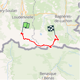
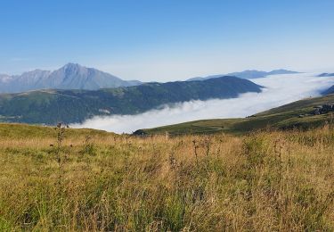
Ruta Senderismo de 31 km a descubrir en Occitania, Altos-Pirineos, Loudenvielle. Esta ruta ha sido propuesta por tracegps.
Descripción
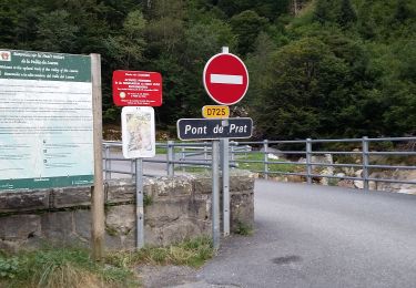
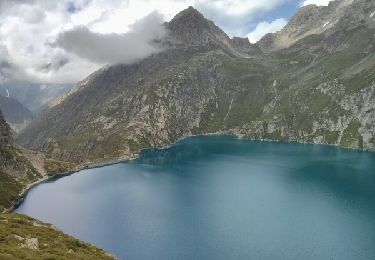
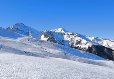
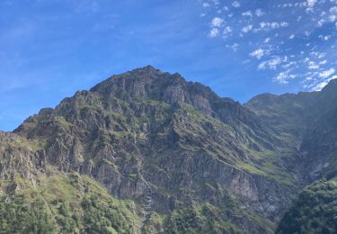
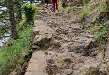
Les Gourgs Blancs Magnifique traversée de Pont du Prat, le lac de Caillauas, au pied des Gourgs Blancs, redescente vers le Lac du Portillon, son refuge. On peut couper la rando en y pasant la nuit. Puis remontée au col de Litérole pour redescendre et remonter au col des Crabioules et retour au pied du Maupas, son refuge et descente vers Luchon par la Vallée du Lys. Attention plusieurs passages délicats de haute montagne !
Localización
Comentarios
Excursiones cerca
![Excursión Senderismo Loudenvielle - Le refuge de la Soula - Photo](https://media.geolcdn.com/t/375/260/ext.jpg?maxdim=2&url=https%3A%2F%2Fservices.sitytrail.com%2FGeolivesWS%2FDownloadMedia.ashx%3FTrailID%3D343973%26Media%3Dfix__20140910123118.jpg)
![Senderismo Senderismo](https://static1.geolcdn.com/sitytour/trail-icons/101.png)
Senderismo
![](/images/other/stat-length.png)
![](https://static1.geolcdn.com/siteimages/upload/files/16400158638029165_repeat_loop_refresh_sync_direction_icon.png)
![Excursión Senderismo Azet - lacs des Miares depuis le col d'Azet - Photo](https://media.geolcdn.com/t/375/260/07c4b873-c4c9-49cc-a0ed-84c4945b022c.jpg&format=jpg&maxdim=2)
![Senderismo Senderismo](https://static1.geolcdn.com/sitytour/trail-icons/101.png)
Senderismo
![](/images/other/stat-length.png)
![](https://static1.geolcdn.com/siteimages/upload/files/16400158638029165_repeat_loop_refresh_sync_direction_icon.png)
![Excursión Senderismo Gouaux-de-Larboust - cap des Hittes & Pic Monségu depuis Gouaux de Larboust - Photo](https://media.geolcdn.com/t/375/260/19698674-5343-4ed7-a128-b1289b696bed.jpg&format=jpg&maxdim=2)
![Senderismo Senderismo](https://static1.geolcdn.com/sitytour/trail-icons/101.png)
Senderismo
![](/images/other/stat-length.png)
![](https://static1.geolcdn.com/siteimages/upload/files/16400158638029165_repeat_loop_refresh_sync_direction_icon.png)
![Excursión Senderismo Loudenvielle - pont de prat 20 lac Caillaouas par refuge de Soula - Photo](https://media.geolcdn.com/t/375/260/3ffa53ff-45ce-43f4-a349-48a3731ab3df.jpg&format=jpg&maxdim=2)
![Senderismo Senderismo](https://static1.geolcdn.com/sitytour/trail-icons/101.png)
Senderismo
![](/images/other/stat-length.png)
![](https://static1.geolcdn.com/siteimages/upload/files/16400158638029165_repeat_loop_refresh_sync_direction_icon.png)
![Excursión Senderismo Germ - Boucle Germ Astau Portillon Soula Germ - Photo](https://media.geolcdn.com/t/375/260/ext.jpg?maxdim=2&url=https%3A%2F%2Fservices.sitytrail.com%2FGeolivesWS%2FDownloadMedia.ashx%3FTrailID%3D332480%26Media%3Dfix__20140807143347.jpg)
![Senderismo Senderismo](https://static1.geolcdn.com/sitytour/trail-icons/101.png)
Senderismo
![](/images/other/stat-length.png)
![](https://static1.geolcdn.com/siteimages/upload/files/16400158638029165_repeat_loop_refresh_sync_direction_icon.png)
![Excursión Raquetas de nieve Germ - Pène de Magnéras - Peyragudes - Photo](https://media.geolcdn.com/t/375/260/1ceab0f9-185b-4a88-addc-237237ba7f9d.jpg&format=jpg&maxdim=2)
![Raquetas de nieve Raquetas de nieve](https://static1.geolcdn.com/sitytour/trail-icons/504.png)
Raquetas de nieve
![](/images/other/stat-length.png)
![](https://static1.geolcdn.com/siteimages/upload/files/16400158638029165_repeat_loop_refresh_sync_direction_icon.png)
![Excursión Senderismo Loudenvielle - Pont de Prat - Photo](https://media.geolcdn.com/t/375/260/37e45cc0-37c1-4ddb-89e7-9c0b365268ed.jpg&format=jpg&maxdim=2)
![Senderismo Senderismo](https://static1.geolcdn.com/sitytour/trail-icons/101.png)
Senderismo
![](/images/other/stat-length.png)
![](https://static1.geolcdn.com/siteimages/upload/files/16400158638029165_repeat_loop_refresh_sync_direction_icon.png)
![Excursión Senderismo Loudenvielle - La Clarabide et refuge de la soula - Photo](https://media.geolcdn.com/t/375/260/162505c0-cd78-4672-9751-51d705bf46b2.jpg&format=jpg&maxdim=2)
![Senderismo Senderismo](https://static1.geolcdn.com/sitytour/trail-icons/101.png)
Senderismo
![](/images/other/stat-length.png)
![](https://static1.geolcdn.com/siteimages/upload/files/16400158638029165_repeat_loop_refresh_sync_direction_icon.png)
![Excursión Senderismo Germ - etangs de Nere - Photo](https://media.geolcdn.com/t/375/260/3f1bd928-7a2c-42d0-a840-f69192ff15a5.jpg&format=jpg&maxdim=2)
![Senderismo Senderismo](https://static1.geolcdn.com/sitytour/trail-icons/101.png)
Senderismo
![](/images/other/stat-length.png)
![](https://static1.geolcdn.com/siteimages/upload/files/16400158638029165_repeat_loop_refresh_sync_direction_icon.png)