![](/images/other/stat-length.png)
![Excursión Bici de montaña Ablain-Saint-Nazaire - La Tranchée de Lorette 60 km édition 2007 - Photo](https://media.geolcdn.com/t/1900/400/ext.pjpeg?maxdim=2&url=https%3A%2F%2Fservices.sitytrail.com%2FGeolivesWS%2FDownloadMedia.ashx%3FTrailID%3D102871%26Media%3D4071_1.jpg)
La Tranchée de Lorette 60 km édition 2007
tracegps
Usuario
![Longitud](/images/other/stat-length.png)
![Altitud máxima](https://static1.geolcdn.com/siteimages/upload/files/1508320355ic_sort_altitude_max_24dp.png)
![Desnivel positivo](https://static1.geolcdn.com/siteimages/upload/files/1508320355ic_sort_den_pos_24dp.png)
![Km-Effort](/images/other/stat-length.png)
![Altitud mínima](https://static1.geolcdn.com/siteimages/upload/files/1508320355ic_sort_altitude_min_24dp.png)
![Desnivel negativo](https://static1.geolcdn.com/siteimages/upload/files/1508320355ic_sort_den_neg_24dp.png)
![Boucle](https://static1.geolcdn.com/siteimages/upload/files/16400158638029165_repeat_loop_refresh_sync_direction_icon.png)
![Bici de montaña](https://static1.geolcdn.com/sitytour/trail-icons/202.png)
4h30
Dificultad : Difícil
![Escanee este código QR para abrir la excursión en la aplicación SityTrail](https://capi.geolives.com/qq0zvz2zws4bq2lad0pu/sitytour/trails/102871/qr.png?size=200)
Aplicación GPS de excursión GRATIS
A propósito
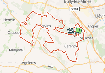
Ruta Bici de montaña de 60 km a descubrir en Alta Francia, Paso de Calais, Ablain-Saint-Nazaire. Esta ruta ha sido propuesta por tracegps.
Descripción
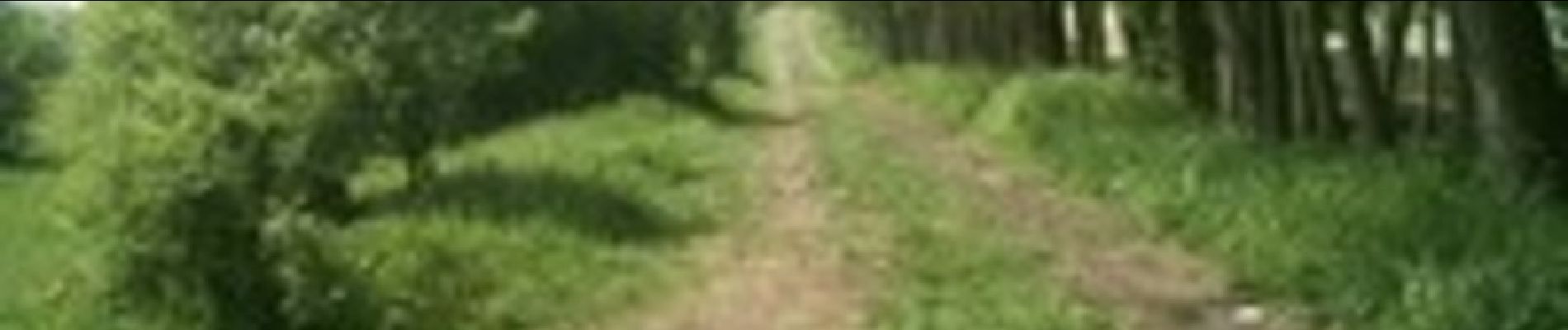
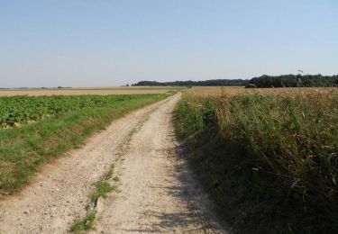
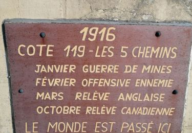
Le site Ch’ti GPS. Perds te pas avec mi ! Tous les détail sur la Tranchée de Lorette 60 km édition 2007. Vidéo La Tranchée 2007 par yvesstmartin C’est dans un cadre exceptionnel et verdoyant que vous allez poser vos roues au guidon de votre machine pour un parcours de 60 kms. Si vous connaissez notre point culminant, je vous parle de Notre Dame de Lorette, je ne suis pas convaincu que vous ayez arpenté tous ces chemins. Et c’est à ses pieds à Ablain-St-Nazaire que vous allez commencer… et oui, vous êtes partis pour une petite (je ne sais pas si le mot est juste…. A découvrir !!!!!!) Grimpette sur la Dame !…
Localización
Comentarios
Excursiones cerca
![Excursión Senderismo Mont-Saint-Éloi - Autour du Mont-Saint-Éloi - Photo](https://media.geolcdn.com/t/375/260/ext.jpg?maxdim=2&url=https%3A%2F%2Fservices.sitytrail.com%2FGeolivesWS%2FDownloadMedia.ashx%3FTrailID%3D215199%26Media%3D15804_6.jpg)
![Senderismo Senderismo](https://static1.geolcdn.com/sitytour/trail-icons/101.png)
Senderismo
![](/images/other/stat-length.png)
![](https://static1.geolcdn.com/siteimages/upload/files/16400158638029165_repeat_loop_refresh_sync_direction_icon.png)
![Excursión Senderismo Liévin - 50 km Lievin en nocturne - Photo](https://media.geolcdn.com/t/375/260/ext.jpg?maxdim=2&url=https%3A%2F%2Fstatic1.geolcdn.com%2Fsiteimages%2Fupload%2Ffiles%2F1553511878bg_sport_marche.png)
![Senderismo Senderismo](https://static1.geolcdn.com/sitytour/trail-icons/101.png)
Senderismo
![](/images/other/stat-length.png)
![](https://static1.geolcdn.com/siteimages/upload/files/16400158638029165_repeat_loop_refresh_sync_direction_icon.png)
![Excursión Marcha nórdica Mont-Saint-Éloi - Les trois abbayes - Photo](https://media.geolcdn.com/t/375/260/a20b48c3-4fa6-4de3-bf52-85a257498803.jpeg&format=jpg&maxdim=2)
![Marcha nórdica Marcha nórdica](https://static1.geolcdn.com/sitytour/trail-icons/102.png)
Marcha nórdica
![](/images/other/stat-length.png)
![](https://static1.geolcdn.com/siteimages/upload/files/16400158638029165_repeat_loop_refresh_sync_direction_icon.png)
![Excursión Senderismo Angres - randonnée pinchonvalles - Photo](https://media.geolcdn.com/t/375/260/b2891722-43d7-4acf-b8f9-14f5909069c3.jpg&format=jpg&maxdim=2)
![Senderismo Senderismo](https://static1.geolcdn.com/sitytour/trail-icons/101.png)
Senderismo
![](/images/other/stat-length.png)
![](https://static1.geolcdn.com/siteimages/upload/files/16400158638029165_repeat_loop_refresh_sync_direction_icon.png)
![Excursión Carrera Aix-Noulette - aix noulette sity guide 25,3 km D530+ - Photo](https://media.geolcdn.com/t/375/260/ext.jpg?maxdim=2&url=https%3A%2F%2Fservices.sitytrail.com%2FGeolivesWS%2FDownloadMedia.ashx%3FTrailID%3D229340%26Media%3Dfix__20131027100347.jpg)
![Carrera Carrera](https://static1.geolcdn.com/sitytour/trail-icons/103.png)
Carrera
![](/images/other/stat-length.png)
![](https://static1.geolcdn.com/siteimages/upload/files/16400158638029165_repeat_loop_refresh_sync_direction_icon.png)
![Excursión Senderismo Neuville-Saint-Vaast - tour Neuville p1 - Photo](https://media.geolcdn.com/t/375/260/ext.jpg?maxdim=2&url=https%3A%2F%2Fservices.sitytrail.com%2FGeolivesWS%2FDownloadMedia.ashx%3FTrailID%3D200820%26Media%3Dfix__20130627100400.jpg)
![Senderismo Senderismo](https://static1.geolcdn.com/sitytour/trail-icons/101.png)
Senderismo
![](/images/other/stat-length.png)
![](https://static1.geolcdn.com/siteimages/upload/files/16400158638029165_repeat_loop_refresh_sync_direction_icon.png)
![Excursión Senderismo Souchez - Souchez-Noulette-Lorette-Ablain - Photo](https://media.geolcdn.com/t/375/260/ext.jpg?maxdim=2&url=https%3A%2F%2Fservices.sitytrail.com%2FGeolivesWS%2FDownloadMedia.ashx%3FTrailID%3D173056%26Media%3D14580_6.jpg)
![Senderismo Senderismo](https://static1.geolcdn.com/sitytour/trail-icons/101.png)
Senderismo
![](/images/other/stat-length.png)
![](https://static1.geolcdn.com/siteimages/upload/files/16400158638029165_repeat_loop_refresh_sync_direction_icon.png)
![Excursión Senderismo Neuville-Saint-Vaast - neuville saint vaast - Photo](https://media.geolcdn.com/t/375/260/ext.jpg?maxdim=2&url=https%3A%2F%2Fservices.sitytrail.com%2FGeolivesWS%2FDownloadMedia.ashx%3FTrailID%3D158596%26Media%3D20121018114604.jpeg)
![Senderismo Senderismo](https://static1.geolcdn.com/sitytour/trail-icons/101.png)
Senderismo
![](/images/other/stat-length.png)
![](https://static1.geolcdn.com/siteimages/upload/files/16400158638029165_repeat_loop_refresh_sync_direction_icon.png)
![Excursión Otra actividad Mont-Saint-Éloi - chemin des 3 abbayes - Photo](https://media.geolcdn.com/t/375/260/ext.jpg?maxdim=2&url=https%3A%2F%2Fservices.sitytrail.com%2FGeolivesWS%2FDownloadMedia.ashx%3FTrailID%3D145071%26Media%3D20120809123008.jpg)
![Otra actividad Otra actividad](https://static1.geolcdn.com/sitytour/trail-icons/900.png)
Otra actividad
![](/images/other/stat-length.png)
![](https://static1.geolcdn.com/siteimages/upload/files/16400158638029165_repeat_loop_refresh_sync_direction_icon.png)