![](/images/other/stat-length.png)
![Excursión Bici de montaña Ferrières-la-Verrerie - Moulins la Marche - De Ferrières la Verrerie à Mahéru - Photo](https://media.geolcdn.com/t/1900/400/ext.pjpeg?maxdim=2&url=https%3A%2F%2Fstatic1.geolcdn.com%2Fsiteimages%2Fupload%2Ffiles%2F1524743154velo.jpg)
Moulins la Marche - De Ferrières la Verrerie à Mahéru
tracegps
Usuario
![Longitud](/images/other/stat-length.png)
Longitud
48 km
![Altitud máxima](https://static1.geolcdn.com/siteimages/upload/files/1508320355ic_sort_altitude_max_24dp.png)
Altitud máxima
313 m
![Desnivel positivo](https://static1.geolcdn.com/siteimages/upload/files/1508320355ic_sort_den_pos_24dp.png)
Desnivel positivo
796 m
![Km-Effort](/images/other/stat-length.png)
Km-Effort
58 km
![Altitud mínima](https://static1.geolcdn.com/siteimages/upload/files/1508320355ic_sort_altitude_min_24dp.png)
Altitud mínima
196 m
![Desnivel negativo](https://static1.geolcdn.com/siteimages/upload/files/1508320355ic_sort_den_neg_24dp.png)
Desnivel negativo
798 m
![Boucle](https://static1.geolcdn.com/siteimages/upload/files/16400158638029165_repeat_loop_refresh_sync_direction_icon.png)
Boucle
Sí
Fecha de creación :
2014-12-10 00:00:00.0
Última modificación :
2014-12-10 00:00:00.0
![Bici de montaña](https://static1.geolcdn.com/sitytour/trail-icons/202.png)
3h30
Dificultad : Difícil
![Escanee este código QR para abrir la excursión en la aplicación SityTrail](https://capi.geolives.com/qq0zvz2zws4bq2lad0pu/sitytour/trails/102676/qr.png?size=200)
Aplicación GPS de excursión GRATIS
A propósito
Ruta Bici de montaña de 48 km a descubrir en Normandía, Orne, Ferrières-la-Verrerie. Esta ruta ha sido propuesta por tracegps.
Descripción
Le nom de la commune de Mahéru viendrait du celte et signifierait « terre rouge », « mahe » signifiant « terre » et « ru », « rouge ». En effet, cela correspond au type de sol de couleur rouge qui est y présent.
Localización
País:
France
Región :
Normandía
Departamento/provincia :
Orne
Municipio :
Ferrières-la-Verrerie
Localidad:
Unknown
Salida:(Dec)
Salida:(UTM)
306427 ; 5392524 (31U) N.
Comentarios
Excursiones cerca
![Excursión Coche La Genevraie - 2023-03-01 maheru Vdu P - Photo](https://media.geolcdn.com/t/375/260/ext.jpg?maxdim=2&url=https%3A%2F%2Fstatic1.geolcdn.com%2Fsiteimages%2Fupload%2Ffiles%2F15247431544x4.jpg)
![Coche Coche](https://static1.geolcdn.com/sitytour/trail-icons/401.png)
2023-03-01 maheru Vdu P
Coche
La Genevraie,
Normandía,
Orne,
France
![](/images/other/stat-length.png)
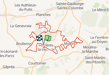
43 km | 49 km-effort
2h 30min
![](https://static1.geolcdn.com/siteimages/upload/files/16400158638029165_repeat_loop_refresh_sync_direction_icon.png)
No
![Excursión Bicicleta Ferrières-la-Verrerie - Entre Risle et Touques - Photo](https://media.geolcdn.com/t/375/260/ext.jpg?maxdim=2&url=https%3A%2F%2Fstatic1.geolcdn.com%2Fsiteimages%2Fupload%2Ffiles%2F1524743154velo.jpg)
![Bicicleta Bicicleta](https://static1.geolcdn.com/sitytour/trail-icons/200.png)
Entre Risle et Touques
Bicicleta
Medio
Ferrières-la-Verrerie,
Normandía,
Orne,
France
![](/images/other/stat-length.png)
181 km | 208 km-effort
Desconocido
![](https://static1.geolcdn.com/siteimages/upload/files/16400158638029165_repeat_loop_refresh_sync_direction_icon.png)
No
![Excursión Senderismo Ferrières-la-Verrerie - Ferrière La-Chênee - Photo](https://media.geolcdn.com/t/375/260/33487492-eff0-486a-875b-bd5c4a035f32.jpg&format=jpg&maxdim=2)
![Senderismo Senderismo](https://static1.geolcdn.com/sitytour/trail-icons/101.png)
Ferrière La-Chênee
Senderismo
Fácil
Ferrières-la-Verrerie,
Normandía,
Orne,
France
![](/images/other/stat-length.png)
9,7 km | 11,4 km-effort
2h 24min
![](https://static1.geolcdn.com/siteimages/upload/files/16400158638029165_repeat_loop_refresh_sync_direction_icon.png)
Sí
![Excursión Senderismo Saint-Germain-le-Vieux - Le Chemin Vert (Boucle) - Photo](https://media.geolcdn.com/t/375/260/ext.jpg?maxdim=2&url=https%3A%2F%2Fstatic1.geolcdn.com%2Fsiteimages%2Fupload%2Ffiles%2F1553511878bg_sport_marche.png)
![Senderismo Senderismo](https://static1.geolcdn.com/sitytour/trail-icons/101.png)
Le Chemin Vert (Boucle)
Senderismo
Muy fácil
Saint-Germain-le-Vieux,
Normandía,
Orne,
France
![](/images/other/stat-length.png)
4,8 km | 5,3 km-effort
1h 40min
![](https://static1.geolcdn.com/siteimages/upload/files/16400158638029165_repeat_loop_refresh_sync_direction_icon.png)
Sí
![Excursión Senderismo Ferrières-la-Verrerie - Ferrières - Photo](https://media.geolcdn.com/t/375/260/ext.jpg?maxdim=2&url=https%3A%2F%2Fstatic1.geolcdn.com%2Fsiteimages%2Fupload%2Ffiles%2F1553511878bg_sport_marche.png)
![Senderismo Senderismo](https://static1.geolcdn.com/sitytour/trail-icons/101.png)
Ferrières
Senderismo
Medio
Ferrières-la-Verrerie,
Normandía,
Orne,
France
![](/images/other/stat-length.png)
5,6 km | 6,4 km-effort
1h 26min
![](https://static1.geolcdn.com/siteimages/upload/files/16400158638029165_repeat_loop_refresh_sync_direction_icon.png)
No
![Excursión Coche Ferrières-la-Verrerie - Ferrière-Sees - Photo](https://media.geolcdn.com/t/375/260/ext.jpg?maxdim=2&url=https%3A%2F%2Fstatic1.geolcdn.com%2Fsiteimages%2Fupload%2Ffiles%2F15247431544x4.jpg)
![Coche Coche](https://static1.geolcdn.com/sitytour/trail-icons/401.png)
Ferrière-Sees
Coche
Muy fácil
Ferrières-la-Verrerie,
Normandía,
Orne,
France
![](/images/other/stat-length.png)
38 km | 43 km-effort
1h 31min
![](https://static1.geolcdn.com/siteimages/upload/files/16400158638029165_repeat_loop_refresh_sync_direction_icon.png)
Sí
![Excursión Senderismo Ferrières-la-Verrerie - FERRIÈRE St-Vandrille - Photo](https://media.geolcdn.com/t/375/260/ext.jpg?maxdim=2&url=https%3A%2F%2Fstatic1.geolcdn.com%2Fsiteimages%2Fupload%2Ffiles%2F1553511878bg_sport_marche.png)
![Senderismo Senderismo](https://static1.geolcdn.com/sitytour/trail-icons/101.png)
FERRIÈRE St-Vandrille
Senderismo
Muy fácil
Ferrières-la-Verrerie,
Normandía,
Orne,
France
![](/images/other/stat-length.png)
8,7 km | 10,1 km-effort
1h 29min
![](https://static1.geolcdn.com/siteimages/upload/files/16400158638029165_repeat_loop_refresh_sync_direction_icon.png)
Sí
![Excursión Senderismo Ferrières-la-Verrerie - FERRIÈRE Brossette - Photo](https://media.geolcdn.com/t/375/260/ext.jpg?maxdim=2&url=https%3A%2F%2Fstatic1.geolcdn.com%2Fsiteimages%2Fupload%2Ffiles%2F1553511878bg_sport_marche.png)
![Senderismo Senderismo](https://static1.geolcdn.com/sitytour/trail-icons/101.png)
FERRIÈRE Brossette
Senderismo
Muy fácil
Ferrières-la-Verrerie,
Normandía,
Orne,
France
![](/images/other/stat-length.png)
3,6 km | 4,8 km-effort
35min
![](https://static1.geolcdn.com/siteimages/upload/files/16400158638029165_repeat_loop_refresh_sync_direction_icon.png)
No
![Excursión Senderismo Ferrières-la-Verrerie - FERRIÈRE Grand frêne - Photo](https://media.geolcdn.com/t/375/260/ext.jpg?maxdim=2&url=https%3A%2F%2Fstatic1.geolcdn.com%2Fsiteimages%2Fupload%2Ffiles%2F1553511878bg_sport_marche.png)
![Senderismo Senderismo](https://static1.geolcdn.com/sitytour/trail-icons/101.png)
FERRIÈRE Grand frêne
Senderismo
Muy fácil
Ferrières-la-Verrerie,
Normandía,
Orne,
France
![](/images/other/stat-length.png)
6,6 km | 8 km-effort
1h 26min
![](https://static1.geolcdn.com/siteimages/upload/files/16400158638029165_repeat_loop_refresh_sync_direction_icon.png)
No