![](/images/other/stat-length.png)
![Excursión Senderismo Ota - Sur les hauteurs d'Ota - Photo](https://media.geolcdn.com/t/1900/400/ext.pjpeg?maxdim=2&url=https%3A%2F%2Fservices.sitytrail.com%2FGeolivesWS%2FDownloadMedia.ashx%3FTrailID%3D102594%26Media%3D3507_6.jpg)
Sur les hauteurs d'Ota
tracegps
Usuario
![Longitud](/images/other/stat-length.png)
![Altitud máxima](https://static1.geolcdn.com/siteimages/upload/files/1508320355ic_sort_altitude_max_24dp.png)
![Desnivel positivo](https://static1.geolcdn.com/siteimages/upload/files/1508320355ic_sort_den_pos_24dp.png)
![Km-Effort](/images/other/stat-length.png)
![Altitud mínima](https://static1.geolcdn.com/siteimages/upload/files/1508320355ic_sort_altitude_min_24dp.png)
![Desnivel negativo](https://static1.geolcdn.com/siteimages/upload/files/1508320355ic_sort_den_neg_24dp.png)
![Boucle](https://static1.geolcdn.com/siteimages/upload/files/16400158638029165_repeat_loop_refresh_sync_direction_icon.png)
![Senderismo](https://static1.geolcdn.com/sitytour/trail-icons/101.png)
11h00
Dificultad : Difícil
![Escanee este código QR para abrir la excursión en la aplicación SityTrail](https://capi.geolives.com/qq0zvz2zws4bq2lad0pu/sitytour/trails/102594/qr.png?size=200)
Aplicación GPS de excursión GRATIS
A propósito
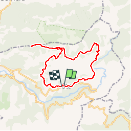
Ruta Senderismo de 16,4 km a descubrir en Córcega, Córcega del Sur, Ota. Esta ruta ha sido propuesta por tracegps.
Descripción
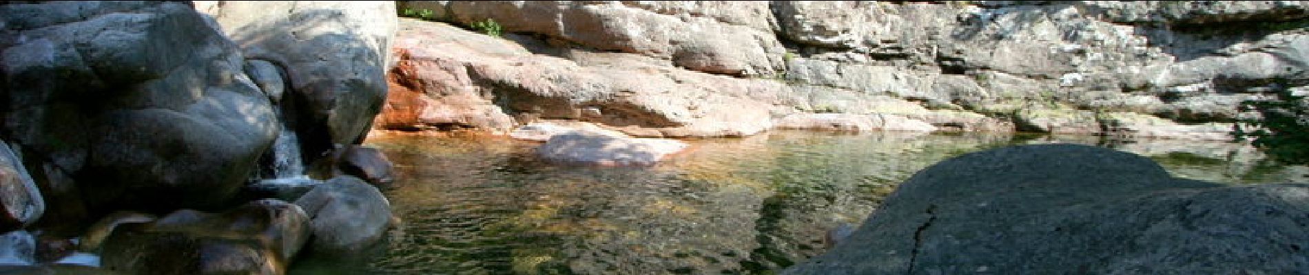
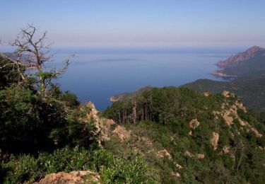
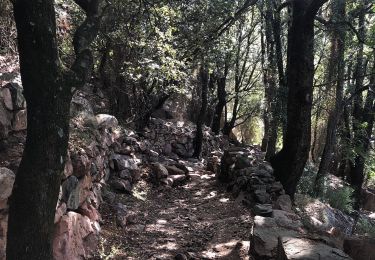
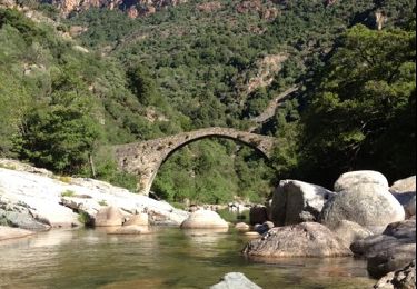
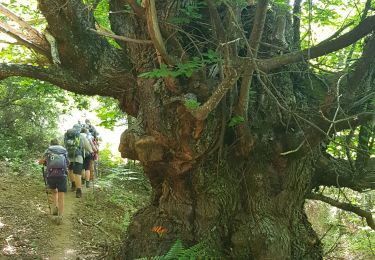
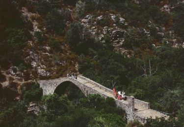
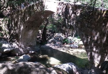
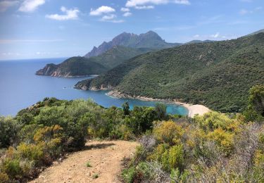
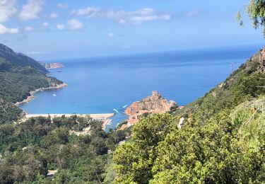
Vous recherchez une balade un peu longue sur de bon sentiers balisés dans le secteur de Porto ? Vous penserez sans doute à Capu d'Orto, d'ailleurs fort fréquenté durant la saison estivale. Pourtant au départ d'Ota à quelques kilomètres de Porto, une boucle bien plus variée vous tend les bras : au programme, Capu San Petru, un autre belvédère sur le golfe de Porto avec une vue originale sur Capu d'Orto, sans oublier la réserve de Scandola; puis après une traversée du col de Larata, un décors de rêve avec des sommets déchiquetés tout proche, et Paglia Orba en vedette en arrière plan... et enfin quelques vasques splendides dans la Lonca à moins de deux heures de l'arrivée ! Tous les détails sur cette page de mon site
Puntos de interés
Localización
Comentarios
Excursiones cerca
![Excursión Senderismo Serriera - Mare e Monti - De Serriera à Ota - Photo](https://media.geolcdn.com/t/375/260/ext.jpg?maxdim=2&url=https%3A%2F%2Fservices.sitytrail.com%2FGeolivesWS%2FDownloadMedia.ashx%3FTrailID%3D109780%26Media%3D4710_1.jpg)
![Senderismo Senderismo](https://static1.geolcdn.com/sitytour/trail-icons/101.png)
Senderismo
![](/images/other/stat-length.png)
![](https://static1.geolcdn.com/siteimages/upload/files/16400158638029165_repeat_loop_refresh_sync_direction_icon.png)
![Excursión Senderismo Ota - Gorge de spelunca - Photo](https://media.geolcdn.com/t/375/260/f6804445-15a3-4e4f-812b-febb15caa6ee.jpg&format=jpg&maxdim=2)
![Senderismo Senderismo](https://static1.geolcdn.com/sitytour/trail-icons/101.png)
Senderismo
![](/images/other/stat-length.png)
![](https://static1.geolcdn.com/siteimages/upload/files/16400158638029165_repeat_loop_refresh_sync_direction_icon.png)
![Excursión Senderismo Ota - gorges de la spelunca et pont, ota, corse - Photo](https://media.geolcdn.com/t/375/260/ext.jpg?maxdim=2&url=https%3A%2F%2Fservices.sitytrail.com%2FGeolivesWS%2FDownloadMedia.ashx%3FTrailID%3D209384%26Media%3D20130801094128.jpg)
![Senderismo Senderismo](https://static1.geolcdn.com/sitytour/trail-icons/101.png)
Senderismo
![](/images/other/stat-length.png)
![](https://static1.geolcdn.com/siteimages/upload/files/16400158638029165_repeat_loop_refresh_sync_direction_icon.png)
![Excursión Senderismo Ota - Ota Mariniana - Photo](https://media.geolcdn.com/t/375/260/b92651dc-1968-4d40-9564-f6b44744830a.jpg&format=jpg&maxdim=2)
![Senderismo Senderismo](https://static1.geolcdn.com/sitytour/trail-icons/101.png)
Senderismo
![](/images/other/stat-length.png)
![](https://static1.geolcdn.com/siteimages/upload/files/16400158638029165_repeat_loop_refresh_sync_direction_icon.png)
![Excursión Senderismo Serriera - Serierra Ota - Photo](https://media.geolcdn.com/t/375/260/e7fdd3ae-25cd-4c33-9101-c2858a640faa.jpg&format=jpg&maxdim=2)
![Senderismo Senderismo](https://static1.geolcdn.com/sitytour/trail-icons/101.png)
Senderismo
![](/images/other/stat-length.png)
![](https://static1.geolcdn.com/siteimages/upload/files/16400158638029165_repeat_loop_refresh_sync_direction_icon.png)
![Excursión A pie Ota - Ota canyons - Photo](https://media.geolcdn.com/t/375/260/4dad7e61-defe-4494-9d4b-3248fec98a02.jpeg&format=jpg&maxdim=2)
![A pie A pie](https://static1.geolcdn.com/sitytour/trail-icons/100.png)
![Excursión Senderismo Évisa - gorges spelunca - Photo](https://media.geolcdn.com/t/375/260/2ba82175-16ea-471a-af7d-9a429f43496d.jpg&format=jpg&maxdim=2)
![Senderismo Senderismo](https://static1.geolcdn.com/sitytour/trail-icons/101.png)
Senderismo
![](/images/other/stat-length.png)
![](https://static1.geolcdn.com/siteimages/upload/files/16400158638029165_repeat_loop_refresh_sync_direction_icon.png)
![Excursión Senderismo Serriera - 20210608 Serriera - Gradelle - Photo](https://media.geolcdn.com/t/375/260/ea9dba27-4698-47fa-9b83-768439d3b81a.jpg&format=jpg&maxdim=2)
![Senderismo Senderismo](https://static1.geolcdn.com/sitytour/trail-icons/101.png)
Senderismo
![](/images/other/stat-length.png)
![](https://static1.geolcdn.com/siteimages/upload/files/16400158638029165_repeat_loop_refresh_sync_direction_icon.png)
![Excursión Senderismo Ota - 20210607 de Otta a Bussaghia- balcons de Porto - Photo](https://media.geolcdn.com/t/375/260/3d6c3fdf-cc74-4e9a-ba21-7c75e8e28103.jpg&format=jpg&maxdim=2)
![Senderismo Senderismo](https://static1.geolcdn.com/sitytour/trail-icons/101.png)
Senderismo
![](/images/other/stat-length.png)
![](https://static1.geolcdn.com/siteimages/upload/files/16400158638029165_repeat_loop_refresh_sync_direction_icon.png)