![](/images/other/stat-length.png)
![Excursión Senderismo Sablé-sur-Sarthe - En forêt de Pincé - Photo](https://media.geolcdn.com/t/1900/400/ext.pjpeg?maxdim=2&url=https%3A%2F%2Fservices.sitytrail.com%2FGeolivesWS%2FDownloadMedia.ashx%3FTrailID%3D102584%26Media%3D3480_1.jpg)
En forêt de Pincé
tracegps
Usuario
![Longitud](/images/other/stat-length.png)
Longitud
22 km
![Altitud máxima](https://static1.geolcdn.com/siteimages/upload/files/1508320355ic_sort_altitude_max_24dp.png)
Altitud máxima
68 m
![Desnivel positivo](https://static1.geolcdn.com/siteimages/upload/files/1508320355ic_sort_den_pos_24dp.png)
Desnivel positivo
193 m
![Km-Effort](/images/other/stat-length.png)
Km-Effort
25 km
![Altitud mínima](https://static1.geolcdn.com/siteimages/upload/files/1508320355ic_sort_altitude_min_24dp.png)
Altitud mínima
26 m
![Desnivel negativo](https://static1.geolcdn.com/siteimages/upload/files/1508320355ic_sort_den_neg_24dp.png)
Desnivel negativo
193 m
![Boucle](https://static1.geolcdn.com/siteimages/upload/files/16400158638029165_repeat_loop_refresh_sync_direction_icon.png)
Boucle
Sí
Fecha de creación :
2014-12-10 00:00:00.0
Última modificación :
2014-12-10 00:00:00.0
![Senderismo](https://static1.geolcdn.com/sitytour/trail-icons/101.png)
5h00
Dificultad : Medio
![Escanee este código QR para abrir la excursión en la aplicación SityTrail](https://capi.geolives.com/qq0zvz2zws4bq2lad0pu/sitytour/trails/102584/qr.png?size=200)
Aplicación GPS de excursión GRATIS
A propósito
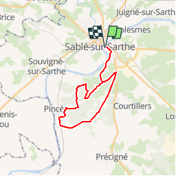
Ruta Senderismo de 22 km a descubrir en Países del Loira, Sarthe, Sablé-sur-Sarthe. Esta ruta ha sido propuesta por tracegps.
Descripción
La forêt de Pincé avec ses chemins de randonnée (Un topoguide est disponible à l’Office de Tourisme du Pays de Sablé)
Localización
País:
France
Región :
Países del Loira
Departamento/provincia :
Sarthe
Municipio :
Sablé-sur-Sarthe
Localidad:
Unknown
Salida:(Dec)
Salida:(UTM)
699843 ; 5301849 (30T) N.
Comentarios
Excursiones cerca
![Excursión Marcha nórdica Sablé-sur-Sarthe - Solesmes - Photo](https://media.geolcdn.com/t/375/260/657e3d52-b3b5-4c25-9633-ce00e4cd355c.jpg&format=jpg&maxdim=2)
![Marcha nórdica Marcha nórdica](https://static1.geolcdn.com/sitytour/trail-icons/102.png)
Solesmes
Marcha nórdica
Muy fácil
Sablé-sur-Sarthe,
Países del Loira,
Sarthe,
France
![](/images/other/stat-length.png)
4,3 km | 4,7 km-effort
1h 14min
![](https://static1.geolcdn.com/siteimages/upload/files/16400158638029165_repeat_loop_refresh_sync_direction_icon.png)
No
![Excursión Bici de montaña Sablé-sur-Sarthe - BRT J4 96KM D+900 - 61MATIN KM D+650 / APRES MIDI 35KM D+ 250 - Photo](https://media.geolcdn.com/t/375/260/52fb78e1-a00a-4def-87b2-6f5b27865666.jpg&format=jpg&maxdim=2)
![Bici de montaña Bici de montaña](https://static1.geolcdn.com/sitytour/trail-icons/202.png)
BRT J4 96KM D+900 - 61MATIN KM D+650 / APRES MIDI 35KM D+ 250
Bici de montaña
Fácil
Sablé-sur-Sarthe,
Países del Loira,
Sarthe,
France
![](/images/other/stat-length.png)
96 km | 108 km-effort
12min
![](https://static1.geolcdn.com/siteimages/upload/files/16400158638029165_repeat_loop_refresh_sync_direction_icon.png)
No
![Excursión Bici de montaña Sablé-sur-Sarthe - R,e,T J4 - Photo](https://media.geolcdn.com/t/375/260/ext.jpg?maxdim=2&url=https%3A%2F%2Fstatic1.geolcdn.com%2Fsiteimages%2Fupload%2Ffiles%2F1524743154velo.jpg)
![Bici de montaña Bici de montaña](https://static1.geolcdn.com/sitytour/trail-icons/202.png)
R,e,T J4
Bici de montaña
Muy fácil
Sablé-sur-Sarthe,
Países del Loira,
Sarthe,
France
![](/images/other/stat-length.png)
110 km | 123 km-effort
8h 17min
![](https://static1.geolcdn.com/siteimages/upload/files/16400158638029165_repeat_loop_refresh_sync_direction_icon.png)
No
![Excursión Senderismo Pincé - Pince - Photo](https://media.geolcdn.com/t/375/260/ext.jpg?maxdim=2&url=https%3A%2F%2Fstatic1.geolcdn.com%2Fsiteimages%2Fupload%2Ffiles%2F1553511878bg_sport_marche.png)
![Senderismo Senderismo](https://static1.geolcdn.com/sitytour/trail-icons/101.png)
Pince
Senderismo
Muy fácil
Pincé,
Países del Loira,
Sarthe,
France
![](/images/other/stat-length.png)
10,2 km | 11,4 km-effort
2h 26min
![](https://static1.geolcdn.com/siteimages/upload/files/16400158638029165_repeat_loop_refresh_sync_direction_icon.png)
Sí
![Excursión Senderismo Sablé-sur-Sarthe - La Sarthe-09-Sablé - Brissarthe - Photo](https://media.geolcdn.com/t/375/260/ext.jpg?maxdim=2&url=https%3A%2F%2Fstatic1.geolcdn.com%2Fsiteimages%2Fupload%2Ffiles%2F1553511878bg_sport_marche.png)
![Senderismo Senderismo](https://static1.geolcdn.com/sitytour/trail-icons/101.png)
La Sarthe-09-Sablé - Brissarthe
Senderismo
Fácil
Sablé-sur-Sarthe,
Países del Loira,
Sarthe,
France
![](/images/other/stat-length.png)
25 km | 27 km-effort
5h 51min
![](https://static1.geolcdn.com/siteimages/upload/files/16400158638029165_repeat_loop_refresh_sync_direction_icon.png)
No
![Excursión Senderismo Juigné-sur-Sarthe - juigné sur sarthe - Photo](https://media.geolcdn.com/t/375/260/ext.jpg?maxdim=2&url=https%3A%2F%2Fstatic1.geolcdn.com%2Fsiteimages%2Fupload%2Ffiles%2F1553511878bg_sport_marche.png)
![Senderismo Senderismo](https://static1.geolcdn.com/sitytour/trail-icons/101.png)
juigné sur sarthe
Senderismo
Fácil
Juigné-sur-Sarthe,
Países del Loira,
Sarthe,
France
![](/images/other/stat-length.png)
14,7 km | 16,2 km-effort
Desconocido
![](https://static1.geolcdn.com/siteimages/upload/files/16400158638029165_repeat_loop_refresh_sync_direction_icon.png)
Sí
![Excursión Senderismo Sablé-sur-Sarthe - Sablé port Solesmes par rive gauche Sarthe et retour par rive droite - Photo](https://media.geolcdn.com/t/375/260/ext.jpg?maxdim=2&url=https%3A%2F%2Fstatic1.geolcdn.com%2Fsiteimages%2Fupload%2Ffiles%2F1553511878bg_sport_marche.png)
![Senderismo Senderismo](https://static1.geolcdn.com/sitytour/trail-icons/101.png)
Sablé port Solesmes par rive gauche Sarthe et retour par rive droite
Senderismo
Medio
Sablé-sur-Sarthe,
Países del Loira,
Sarthe,
France
![](/images/other/stat-length.png)
7,6 km | 8,6 km-effort
2h 30min
![](https://static1.geolcdn.com/siteimages/upload/files/16400158638029165_repeat_loop_refresh_sync_direction_icon.png)
Sí
![Excursión Senderismo Sablé-sur-Sarthe - 2021-10-24 rando jean - Photo](https://media.geolcdn.com/t/375/260/ext.jpg?maxdim=2&url=https%3A%2F%2Fstatic1.geolcdn.com%2Fsiteimages%2Fupload%2Ffiles%2F1553511878bg_sport_marche.png)
![Senderismo Senderismo](https://static1.geolcdn.com/sitytour/trail-icons/101.png)
2021-10-24 rando jean
Senderismo
Fácil
Sablé-sur-Sarthe,
Países del Loira,
Sarthe,
France
![](/images/other/stat-length.png)
4 km | 4,6 km-effort
51min
![](https://static1.geolcdn.com/siteimages/upload/files/16400158638029165_repeat_loop_refresh_sync_direction_icon.png)
Sí
![Excursión Marcha nórdica Juigné-sur-Sarthe - Abbaye de Solesmes - Photo](https://media.geolcdn.com/t/375/260/ext.jpg?maxdim=2&url=https%3A%2F%2Fstatic1.geolcdn.com%2Fsiteimages%2Fupload%2Ffiles%2F1545311037marcheuse_200dpi.jpg)
![Marcha nórdica Marcha nórdica](https://static1.geolcdn.com/sitytour/trail-icons/102.png)
Abbaye de Solesmes
Marcha nórdica
Muy fácil
Juigné-sur-Sarthe,
Países del Loira,
Sarthe,
France
![](/images/other/stat-length.png)
3 km | 3,6 km-effort
Desconocido
![](https://static1.geolcdn.com/siteimages/upload/files/16400158638029165_repeat_loop_refresh_sync_direction_icon.png)
Sí
belle promenade en forêt sans aucune difficulté