![](/images/other/stat-length.png)
![Excursión Bici de montaña Saint-Philbert-sur-Orne - Espace VTT FFC Suisse Normande - Le Blanc Rocher - La Roche d'Oëtre - Photo](https://media.geolcdn.com/t/1900/400/ext.pjpeg?maxdim=2&url=https%3A%2F%2Fservices.sitytrail.com%2FGeolivesWS%2FDownloadMedia.ashx%3FTrailID%3D102461%26Media%3D3138_1.jpg)
Espace VTT FFC Suisse Normande - Le Blanc Rocher - La Roche d'Oëtre
tracegps
Usuario
![Longitud](/images/other/stat-length.png)
![Altitud máxima](https://static1.geolcdn.com/siteimages/upload/files/1508320355ic_sort_altitude_max_24dp.png)
![Desnivel positivo](https://static1.geolcdn.com/siteimages/upload/files/1508320355ic_sort_den_pos_24dp.png)
![Km-Effort](/images/other/stat-length.png)
![Altitud mínima](https://static1.geolcdn.com/siteimages/upload/files/1508320355ic_sort_altitude_min_24dp.png)
![Desnivel negativo](https://static1.geolcdn.com/siteimages/upload/files/1508320355ic_sort_den_neg_24dp.png)
![Boucle](https://static1.geolcdn.com/siteimages/upload/files/16400158638029165_repeat_loop_refresh_sync_direction_icon.png)
![Bici de montaña](https://static1.geolcdn.com/sitytour/trail-icons/202.png)
1h00
Dificultad : Medio
![Escanee este código QR para abrir la excursión en la aplicación SityTrail](https://capi.geolives.com/qq0zvz2zws4bq2lad0pu/sitytour/trails/102461/qr.png?size=200)
Aplicación GPS de excursión GRATIS
A propósito
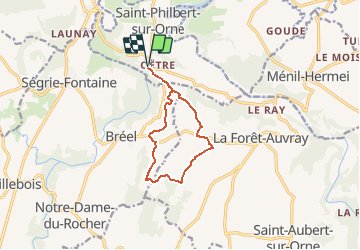
Ruta Bici de montaña de 9,3 km a descubrir en Normandía, Orne, Saint-Philbert-sur-Orne. Esta ruta ha sido propuesta por tracegps.
Descripción
Espace VTT FFC de la Suisse Normande. Circuit labellisé par la Fédération Française de Cyclisme. NOUVEAU TOPO GUIDE VTT FFC Suisse Normande Edité par les Communautés de Communes de la Suisse Normande, du Bocage Athisien, du Pays de Falaise, du Val d'Orne et du Pays de Condé et de la Druance le topo guide VTT FFC Suisse Normande regroupe 38 circuits, et le Tour de la Suisse Normande.
Localización
Comentarios
Excursiones cerca
![Excursión Bici de montaña Pont-d'Ouilly - La Petite Suisse Normande 2014 - Pont-d'Ouilly - Photo](https://media.geolcdn.com/t/375/260/ext.jpg?maxdim=2&url=https%3A%2F%2Fservices.sitytrail.com%2FGeolivesWS%2FDownloadMedia.ashx%3FTrailID%3D317875%26Media%3D17266_3.jpg)
![Bici de montaña Bici de montaña](https://static1.geolcdn.com/sitytour/trail-icons/202.png)
Bici de montaña
![](/images/other/stat-length.png)
![](https://static1.geolcdn.com/siteimages/upload/files/16400158638029165_repeat_loop_refresh_sync_direction_icon.png)
![Excursión Senderismo Saint-Philbert-sur-Orne - Autour des roches d'oetre - Photo](https://media.geolcdn.com/t/375/260/ext.jpg?maxdim=2&url=https%3A%2F%2Fservices.sitytrail.com%2FGeolivesWS%2FDownloadMedia.ashx%3FTrailID%3D257893%26Media%3Dfix__20140316172042.jpg)
![Senderismo Senderismo](https://static1.geolcdn.com/sitytour/trail-icons/101.png)
Senderismo
![](/images/other/stat-length.png)
![](https://static1.geolcdn.com/siteimages/upload/files/16400158638029165_repeat_loop_refresh_sync_direction_icon.png)
![Excursión Senderismo Athis-Val-de-Rouvre - Rando botanique - Ségrie Fontaine - Photo](https://media.geolcdn.com/t/375/260/ext.jpg?maxdim=2&url=https%3A%2F%2Fservices.sitytrail.com%2FGeolivesWS%2FDownloadMedia.ashx%3FTrailID%3D111668%26Media%3D7906_2.jpg)
![Senderismo Senderismo](https://static1.geolcdn.com/sitytour/trail-icons/101.png)
Senderismo
![](/images/other/stat-length.png)
![](https://static1.geolcdn.com/siteimages/upload/files/16400158638029165_repeat_loop_refresh_sync_direction_icon.png)
![Excursión Senderismo Saint-Philbert-sur-Orne - Roche d’oëtre sentier du Granite - Photo](https://media.geolcdn.com/t/375/260/78560dc1-be20-40f6-8958-64644ce9c02c.jpg&format=jpg&maxdim=2)
![Senderismo Senderismo](https://static1.geolcdn.com/sitytour/trail-icons/101.png)
Senderismo
![](/images/other/stat-length.png)
![](https://static1.geolcdn.com/siteimages/upload/files/16400158638029165_repeat_loop_refresh_sync_direction_icon.png)
![Excursión Senderismo Saint-Philbert-sur-Orne - Circuit des méandres - Photo](https://media.geolcdn.com/t/375/260/d0425abd-8b8b-4124-ab4b-e002210b2bca.jpg&format=jpg&maxdim=2)
![Senderismo Senderismo](https://static1.geolcdn.com/sitytour/trail-icons/101.png)
Senderismo
![](/images/other/stat-length.png)
![](https://static1.geolcdn.com/siteimages/upload/files/16400158638029165_repeat_loop_refresh_sync_direction_icon.png)
![Excursión Senderismo Ménil-Hubert-sur-Orne - De Rouvroy aux Roches d'Oetre par le sentier des Méandres - Photo](https://media.geolcdn.com/t/375/260/21e229b0-b429-4d44-ac88-f06ccf36f81a.jpg&format=jpg&maxdim=2)
![Senderismo Senderismo](https://static1.geolcdn.com/sitytour/trail-icons/101.png)
Senderismo
![](/images/other/stat-length.png)
![](https://static1.geolcdn.com/siteimages/upload/files/16400158638029165_repeat_loop_refresh_sync_direction_icon.png)
![Excursión A pie Athis-Val-de-Rouvre - Les Fontaines - Photo](https://media.geolcdn.com/t/375/260/36c8ec6b-f4f7-4eb2-9b97-30e9263572cf.jpeg&format=jpg&maxdim=2)
![A pie A pie](https://static1.geolcdn.com/sitytour/trail-icons/100.png)
A pie
![](/images/other/stat-length.png)
![](https://static1.geolcdn.com/siteimages/upload/files/16400158638029165_repeat_loop_refresh_sync_direction_icon.png)
![Excursión A pie Athis-Val-de-Rouvre - Sentier du granite - Photo](https://media.geolcdn.com/t/375/260/baf151c8-29ed-422f-88ef-be9c392d457c.jpeg&format=jpg&maxdim=2)
![A pie A pie](https://static1.geolcdn.com/sitytour/trail-icons/100.png)
A pie
![](/images/other/stat-length.png)
![](https://static1.geolcdn.com/siteimages/upload/files/16400158638029165_repeat_loop_refresh_sync_direction_icon.png)
![Excursión A pie Saint-Philbert-sur-Orne - Entre Orne et Rouvre - Photo](https://media.geolcdn.com/t/375/260/baf151c8-29ed-422f-88ef-be9c392d457c.jpeg&format=jpg&maxdim=2)
![A pie A pie](https://static1.geolcdn.com/sitytour/trail-icons/100.png)
A pie
![](/images/other/stat-length.png)
![](https://static1.geolcdn.com/siteimages/upload/files/16400158638029165_repeat_loop_refresh_sync_direction_icon.png)