![](/images/other/stat-length.png)
![Excursión Bici de montaña Grane - Espace VTT FFC Vallée de la Drôme Diois - Circuit n° 1 - La Grenette - Photo](https://media.geolcdn.com/t/1900/400/ext.pjpeg?maxdim=2&url=https%3A%2F%2Fservices.sitytrail.com%2FGeolivesWS%2FDownloadMedia.ashx%3FTrailID%3D102428%26Media%3D3073_1.jpg)
Espace VTT FFC Vallée de la Drôme Diois - Circuit n° 1 - La Grenette
tracegps
Usuario
![Longitud](/images/other/stat-length.png)
![Altitud máxima](https://static1.geolcdn.com/siteimages/upload/files/1508320355ic_sort_altitude_max_24dp.png)
![Desnivel positivo](https://static1.geolcdn.com/siteimages/upload/files/1508320355ic_sort_den_pos_24dp.png)
![Km-Effort](/images/other/stat-length.png)
![Altitud mínima](https://static1.geolcdn.com/siteimages/upload/files/1508320355ic_sort_altitude_min_24dp.png)
![Desnivel negativo](https://static1.geolcdn.com/siteimages/upload/files/1508320355ic_sort_den_neg_24dp.png)
![Boucle](https://static1.geolcdn.com/siteimages/upload/files/16400158638029165_repeat_loop_refresh_sync_direction_icon.png)
![Bici de montaña](https://static1.geolcdn.com/sitytour/trail-icons/202.png)
19m
Dificultad : Fácil
![Escanee este código QR para abrir la excursión en la aplicación SityTrail](https://capi.geolives.com/qq0zvz2zws4bq2lad0pu/sitytour/trails/102428/qr.png?size=200)
Aplicación GPS de excursión GRATIS
A propósito
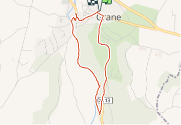
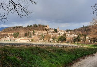
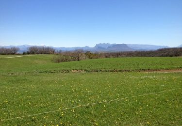
Ruta Bici de montaña de 3,7 km a descubrir en Auvergne-Rhône-Alpes, Drôme, Grane. Esta ruta ha sido propuesta por tracegps.
Descripción
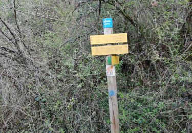
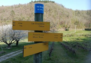
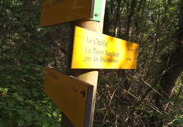
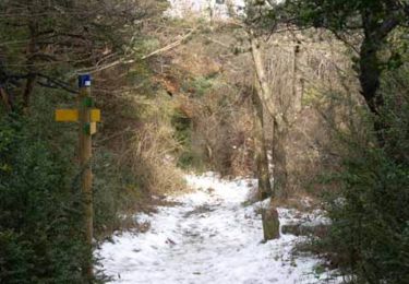
Espace VTT FFC Vallée de la Drôme Diois Circuit officiel labellisé par la Fédération Française de Cyclisme. ( numérisation par Joël Vachon) Le Diois Vallée de la Drôme N°73 avec comme club support le vélo club Saillans qui gère 11 points de départ représentant un total de 1590 km environ dont Grane avec 6 circuits pour 120 km Circuit d’initiation, de la «Place du Champ de Mars » prendre la direction de la «Pierre Sanglante» par la route de Roche, vers «les Tennis» et «Plaisance» par un bon chemin descendant, puis à «Plaisance» (vue sur la ferme fortifiée) retour vers «La Planche» et «Grâne» par un petit sentier parfois technique dans la forêt et après la traversée du ruisseau sur une passerelle étroite où vous pouvez apercevoir la truite et longer les bords du ruisseau , remontée du village par les ruelles et la Grande rue au pied du clocher.
Localización
Comentarios
Excursiones cerca
![Excursión Senderismo Grane - Grane-Les Roberts 13km - Photo](https://media.geolcdn.com/t/375/260/5618d6af-4205-4e85-865b-a90a6c161a8c.jpg&format=jpg&maxdim=2)
![Senderismo Senderismo](https://static1.geolcdn.com/sitytour/trail-icons/101.png)
Senderismo
![](/images/other/stat-length.png)
![](https://static1.geolcdn.com/siteimages/upload/files/16400158638029165_repeat_loop_refresh_sync_direction_icon.png)
![Excursión Senderismo Grane - grane bois de la dame Pierre sanglante - Photo](https://media.geolcdn.com/t/375/260/ext.jpg?maxdim=2&url=https%3A%2F%2Fstatic1.geolcdn.com%2Fsiteimages%2Fupload%2Ffiles%2F1553511878bg_sport_marche.png)
![Senderismo Senderismo](https://static1.geolcdn.com/sitytour/trail-icons/101.png)
Senderismo
![](/images/other/stat-length.png)
![](https://static1.geolcdn.com/siteimages/upload/files/16400158638029165_repeat_loop_refresh_sync_direction_icon.png)
![Excursión Senderismo Allex - Balade des Ramieres à livron - Photo](https://media.geolcdn.com/t/375/260/ext.jpg?maxdim=2&url=https%3A%2F%2Fstatic1.geolcdn.com%2Fsiteimages%2Fupload%2Ffiles%2F1553511878bg_sport_marche.png)
![Senderismo Senderismo](https://static1.geolcdn.com/sitytour/trail-icons/101.png)
Senderismo
![](/images/other/stat-length.png)
![](https://static1.geolcdn.com/siteimages/upload/files/16400158638029165_repeat_loop_refresh_sync_direction_icon.png)
![Excursión Senderismo Grane - De Val Brian au Mont Brian - Photo](https://media.geolcdn.com/t/375/260/bc6d4726-3ae6-481c-b979-5b3a43f540de.jpg&format=jpg&maxdim=2)
![Senderismo Senderismo](https://static1.geolcdn.com/sitytour/trail-icons/101.png)
Senderismo
![](/images/other/stat-length.png)
![](https://static1.geolcdn.com/siteimages/upload/files/16400158638029165_repeat_loop_refresh_sync_direction_icon.png)
![Excursión Senderismo Grane - De Val Brian au lac sans nom - Photo](https://media.geolcdn.com/t/375/260/0dfbfd01-b6ba-4eaf-a75e-fcb6bdc5753b.jpg&format=jpg&maxdim=2)
![Senderismo Senderismo](https://static1.geolcdn.com/sitytour/trail-icons/101.png)
Senderismo
![](/images/other/stat-length.png)
![](https://static1.geolcdn.com/siteimages/upload/files/16400158638029165_repeat_loop_refresh_sync_direction_icon.png)
![Excursión Senderismo Grane - Grane jour 6 - Photo](https://media.geolcdn.com/t/375/260/78ac0163-d323-44da-a827-813a00e867ba.jpg&format=jpg&maxdim=2)
![Senderismo Senderismo](https://static1.geolcdn.com/sitytour/trail-icons/101.png)
Senderismo
![](/images/other/stat-length.png)
![](https://static1.geolcdn.com/siteimages/upload/files/16400158638029165_repeat_loop_refresh_sync_direction_icon.png)
![Excursión Senderismo Grane - Malaire - Photo](https://media.geolcdn.com/t/375/260/ext.jpg?maxdim=2&url=https%3A%2F%2Fservices.sitytrail.com%2FGeolivesWS%2FDownloadMedia.ashx%3FTrailID%3D184892%26Media%3D20130414140222.jpg)
![Senderismo Senderismo](https://static1.geolcdn.com/sitytour/trail-icons/101.png)
Senderismo
![](/images/other/stat-length.png)
![](https://static1.geolcdn.com/siteimages/upload/files/16400158638029165_repeat_loop_refresh_sync_direction_icon.png)
![Excursión Senderismo Grane - Boucle pédestre n°43 - Les Micouleaux - Photo](https://media.geolcdn.com/t/375/260/ext.jpg?maxdim=2&url=https%3A%2F%2Fservices.sitytrail.com%2FGeolivesWS%2FDownloadMedia.ashx%3FTrailID%3D109062%26Media%3D3084_1.jpg)
![Senderismo Senderismo](https://static1.geolcdn.com/sitytour/trail-icons/101.png)
Senderismo
![](/images/other/stat-length.png)
![](https://static1.geolcdn.com/siteimages/upload/files/16400158638029165_repeat_loop_refresh_sync_direction_icon.png)
![Excursión Senderismo Grane - Boucle pédestre n°42 - Bois de la Dame - La Pierre Sanglante - Photo](https://media.geolcdn.com/t/375/260/ext.jpg?maxdim=2&url=https%3A%2F%2Fservices.sitytrail.com%2FGeolivesWS%2FDownloadMedia.ashx%3FTrailID%3D109061%26Media%3D3083_2.jpg)
![Senderismo Senderismo](https://static1.geolcdn.com/sitytour/trail-icons/101.png)
Senderismo
![](/images/other/stat-length.png)
![](https://static1.geolcdn.com/siteimages/upload/files/16400158638029165_repeat_loop_refresh_sync_direction_icon.png)