![](/images/other/stat-length.png)
![Excursión Senderismo La Ferrière - Autout de La Ferrière et Marray - Photo](https://media.geolcdn.com/t/1900/400/ext.pjpeg?maxdim=2&url=https%3A%2F%2Fstatic1.geolcdn.com%2Fsiteimages%2Fupload%2Ffiles%2F1553511878bg_sport_marche.png)
Autout de La Ferrière et Marray
tracegps
Usuario
![Longitud](/images/other/stat-length.png)
Longitud
16,7 km
![Altitud máxima](https://static1.geolcdn.com/siteimages/upload/files/1508320355ic_sort_altitude_max_24dp.png)
Altitud máxima
186 m
![Desnivel positivo](https://static1.geolcdn.com/siteimages/upload/files/1508320355ic_sort_den_pos_24dp.png)
Desnivel positivo
219 m
![Km-Effort](/images/other/stat-length.png)
Km-Effort
19,6 km
![Altitud mínima](https://static1.geolcdn.com/siteimages/upload/files/1508320355ic_sort_altitude_min_24dp.png)
Altitud mínima
98 m
![Desnivel negativo](https://static1.geolcdn.com/siteimages/upload/files/1508320355ic_sort_den_neg_24dp.png)
Desnivel negativo
219 m
![Boucle](https://static1.geolcdn.com/siteimages/upload/files/16400158638029165_repeat_loop_refresh_sync_direction_icon.png)
Boucle
Sí
Fecha de creación :
2014-12-10 00:00:00.0
Última modificación :
2014-12-10 00:00:00.0
![Senderismo](https://static1.geolcdn.com/sitytour/trail-icons/101.png)
3h00
Dificultad : Medio
![Escanee este código QR para abrir la excursión en la aplicación SityTrail](https://capi.geolives.com/qq0zvz2zws4bq2lad0pu/sitytour/trails/102363/qr.png?size=200)
Aplicación GPS de excursión GRATIS
A propósito
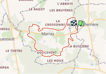
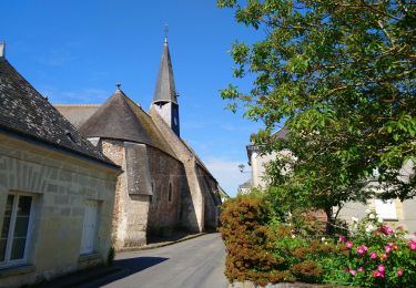
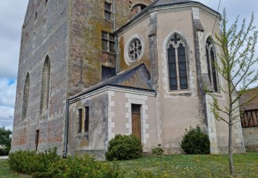
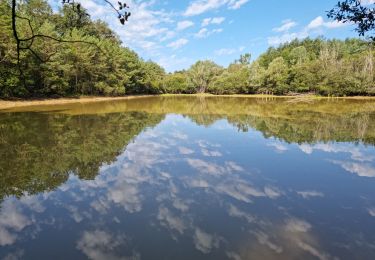
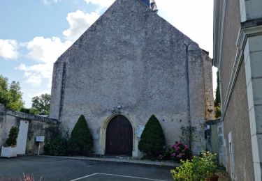
Ruta Senderismo de 16,7 km a descubrir en Centro, Indre y Loira, La Ferrière. Esta ruta ha sido propuesta por tracegps.
Descripción
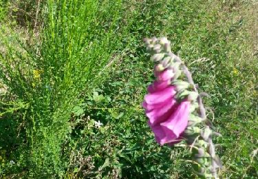
Boucle autour de La Ferrière et Marray, 17km avec beaucoup de forêt, balisage bleu, balisage temporaire probable, circuit proposé pour une sortie du comité local.
Localización
País:
France
Región :
Centro
Departamento/provincia :
Indre y Loira
Municipio :
La Ferrière
Localidad:
Unknown
Salida:(Dec)
Salida:(UTM)
329721 ; 5276997 (31T) N.
Comentarios
Excursiones cerca
![Excursión Senderismo Saint-Laurent-en-Gâtines - Saint-Laurent-en-Gâtines - variante du PR Chemin de Chenusson - 10.2km 90m 2h25 - 2023 07 30 - Photo](https://media.geolcdn.com/t/375/260/9480277e-5582-454b-ba7d-ba1780556f7f.jpg&format=jpg&maxdim=2)
![Senderismo Senderismo](https://static1.geolcdn.com/sitytour/trail-icons/101.png)
Saint-Laurent-en-Gâtines - variante du PR Chemin de Chenusson - 10.2km 90m 2h...
Senderismo
Fácil
Saint-Laurent-en-Gâtines,
Centro,
Indre y Loira,
France
![](/images/other/stat-length.png)
10,3 km | 11,5 km-effort
2h 25min
![](https://static1.geolcdn.com/siteimages/upload/files/16400158638029165_repeat_loop_refresh_sync_direction_icon.png)
Sí
![Excursión Senderismo La Ferrière - la Ferrière - le Moulin à Vent à Saint-Laurent-en-Gâtines - 14.9km 115m 3h20 (30mn) - 2023 07 30 - Photo](https://media.geolcdn.com/t/375/260/d3c77c4c-8983-42fc-ab09-ce988903c800.jpg&format=jpg&maxdim=2)
![Senderismo Senderismo](https://static1.geolcdn.com/sitytour/trail-icons/101.png)
la Ferrière - le Moulin à Vent à Saint-Laurent-en-Gâtines - 14.9km 115m 3h20 ...
Senderismo
Fácil
La Ferrière,
Centro,
Indre y Loira,
France
![](/images/other/stat-length.png)
14,9 km | 16,5 km-effort
3h 20min
![](https://static1.geolcdn.com/siteimages/upload/files/16400158638029165_repeat_loop_refresh_sync_direction_icon.png)
Sí
![Excursión Senderismo Saint-Laurent-en-Gâtines - Saint-Laurent-en-Gâtines - Circuit jaune avec variante le Sentier - 18.7km 120m 4h30 - 2022 05 01 - Photo](https://media.geolcdn.com/t/375/260/8fa477e2-239d-46b3-938e-82d894cde1c1.jpg&format=jpg&maxdim=2)
![Senderismo Senderismo](https://static1.geolcdn.com/sitytour/trail-icons/101.png)
Saint-Laurent-en-Gâtines - Circuit jaune avec variante le Sentier - 18.7km 12...
Senderismo
Fácil
Saint-Laurent-en-Gâtines,
Centro,
Indre y Loira,
France
![](/images/other/stat-length.png)
18,7 km | 20 km-effort
4h 30min
![](https://static1.geolcdn.com/siteimages/upload/files/16400158638029165_repeat_loop_refresh_sync_direction_icon.png)
Sí
![Excursión Senderismo Marray - Marray - 2 boucles - 19.2km 245m 5h05 (30mn) - 2021 06 09 - Photo](https://media.geolcdn.com/t/375/260/45a2bb2e-f724-44bd-9abd-5e3ed1735943.jpg&format=jpg&maxdim=2)
![Senderismo Senderismo](https://static1.geolcdn.com/sitytour/trail-icons/101.png)
Marray - 2 boucles - 19.2km 245m 5h05 (30mn) - 2021 06 09
Senderismo
Medio
Marray,
Centro,
Indre y Loira,
France
![](/images/other/stat-length.png)
19,2 km | 22 km-effort
5h 5min
![](https://static1.geolcdn.com/siteimages/upload/files/16400158638029165_repeat_loop_refresh_sync_direction_icon.png)
Sí
![Excursión Senderismo Saint-Laurent-en-Gâtines - Saint-Laurent-en-Gatines - Photo](https://media.geolcdn.com/t/375/260/3bcc51bc-dce3-484e-8c68-f9b9dd3f130d.jpg&format=jpg&maxdim=2)
![Senderismo Senderismo](https://static1.geolcdn.com/sitytour/trail-icons/101.png)
Saint-Laurent-en-Gatines
Senderismo
Difícil
Saint-Laurent-en-Gâtines,
Centro,
Indre y Loira,
France
![](/images/other/stat-length.png)
13,1 km | 14,9 km-effort
3h 23min
![](https://static1.geolcdn.com/siteimages/upload/files/16400158638029165_repeat_loop_refresh_sync_direction_icon.png)
Sí
![Excursión Senderismo Marray - Marray - Les versants de la Dême - Photo](https://media.geolcdn.com/t/375/260/a9d7133a-9eea-405b-99f5-2661c5c29f57.jpg&format=jpg&maxdim=2)
![Senderismo Senderismo](https://static1.geolcdn.com/sitytour/trail-icons/101.png)
Marray - Les versants de la Dême
Senderismo
Medio
Marray,
Centro,
Indre y Loira,
France
![](/images/other/stat-length.png)
12,8 km | 15,2 km-effort
3h 27min
![](https://static1.geolcdn.com/siteimages/upload/files/16400158638029165_repeat_loop_refresh_sync_direction_icon.png)
Sí
![Excursión Senderismo La Ferrière - La Ferrière - Photo](https://media.geolcdn.com/t/375/260/2b9da9c8-3be2-44f6-92a4-c42159cd8b74.jpg&format=jpg&maxdim=2)
![Senderismo Senderismo](https://static1.geolcdn.com/sitytour/trail-icons/101.png)
La Ferrière
Senderismo
Fácil
La Ferrière,
Centro,
Indre y Loira,
France
![](/images/other/stat-length.png)
10,6 km | 11,9 km-effort
2h 42min
![](https://static1.geolcdn.com/siteimages/upload/files/16400158638029165_repeat_loop_refresh_sync_direction_icon.png)
Sí
![Excursión Senderismo Les Hermites - sentier de l'ermite - Photo](https://media.geolcdn.com/t/375/260/ext.jpg?maxdim=2&url=https%3A%2F%2Fservices.sitytrail.com%2FGeolivesWS%2FDownloadMedia.ashx%3FTrailID%3D315383%26Media%3Dfix__20140622121912.jpg)
![Senderismo Senderismo](https://static1.geolcdn.com/sitytour/trail-icons/101.png)
sentier de l'ermite
Senderismo
Muy fácil
Les Hermites,
Centro,
Indre y Loira,
France
![](/images/other/stat-length.png)
25 km | 28 km-effort
5h 29min
![](https://static1.geolcdn.com/siteimages/upload/files/16400158638029165_repeat_loop_refresh_sync_direction_icon.png)
Sí
![Excursión Senderismo Saint-Laurent-en-Gâtines - saint laurent en gatine - Photo](https://media.geolcdn.com/t/375/260/ext.jpg?maxdim=2&url=https%3A%2F%2Fservices.sitytrail.com%2FGeolivesWS%2FDownloadMedia.ashx%3FTrailID%3D265906%26Media%3Dfix__20140412112239.jpg)
![Senderismo Senderismo](https://static1.geolcdn.com/sitytour/trail-icons/101.png)
saint laurent en gatine
Senderismo
Fácil
Saint-Laurent-en-Gâtines,
Centro,
Indre y Loira,
France
![](/images/other/stat-length.png)
13,9 km | 14,9 km-effort
2h 59min
![](https://static1.geolcdn.com/siteimages/upload/files/16400158638029165_repeat_loop_refresh_sync_direction_icon.png)
Sí