![](/images/other/stat-length.png)
![Excursión Bici de montaña Bazeilles - Espace VTT FFC Pays Sedanais Le Banet - Circuit n° 16 - Photo](https://media.geolcdn.com/t/1900/400/ext.pjpeg?maxdim=2&url=https%3A%2F%2Fservices.sitytrail.com%2FGeolivesWS%2FDownloadMedia.ashx%3FTrailID%3D102289%26Media%3D2750_1.jpg)
Espace VTT FFC Pays Sedanais Le Banet - Circuit n° 16
tracegps
Usuario
![Longitud](/images/other/stat-length.png)
![Altitud máxima](https://static1.geolcdn.com/siteimages/upload/files/1508320355ic_sort_altitude_max_24dp.png)
![Desnivel positivo](https://static1.geolcdn.com/siteimages/upload/files/1508320355ic_sort_den_pos_24dp.png)
![Km-Effort](/images/other/stat-length.png)
![Altitud mínima](https://static1.geolcdn.com/siteimages/upload/files/1508320355ic_sort_altitude_min_24dp.png)
![Desnivel negativo](https://static1.geolcdn.com/siteimages/upload/files/1508320355ic_sort_den_neg_24dp.png)
![Boucle](https://static1.geolcdn.com/siteimages/upload/files/16400158638029165_repeat_loop_refresh_sync_direction_icon.png)
![Bici de montaña](https://static1.geolcdn.com/sitytour/trail-icons/202.png)
2h00
Dificultad : Difícil
![Escanee este código QR para abrir la excursión en la aplicación SityTrail](https://capi.geolives.com/qq0zvz2zws4bq2lad0pu/sitytour/trails/102289/qr.png?size=200)
Aplicación GPS de excursión GRATIS
A propósito
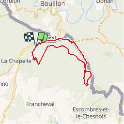
Ruta Bici de montaña de 23 km a descubrir en Gran Este, Ardenas, Bazeilles. Esta ruta ha sido propuesta por tracegps.
Descripción
Espace VTT FFC Pays Sedanais Le Banet Circuit officiel labellisé par la Fédération Française de Cyclisme. Le Pays sedanais comporte 16 circuits balisés. Grâce à la variété des sites, les sorties sont adaptées aussi bien aux balades en famille qu'aux raids en solitaire. Votre périple pourra vous mener à l'aplomb de la vallée de la Semois entourant la superbe petite bourgade de Bouillon, en Belgique. Attention : Les pistes sont interdites les jours de chasse en battue, la nuit et par temps de neige. Sedan Sprint Club
Localización
Comentarios
Excursiones cerca
![Excursión Senderismo Bouillon - RB-LUX-13 - Les belvédères bouillonnais - Photo](https://media.geolcdn.com/t/375/260/ext.jpg?maxdim=2&url=https%3A%2F%2Fservices.sitytrail.com%2FGeolivesWS%2FDownloadMedia.ashx%3FTrailID%3D179618%26Media%3Dc93ae6e1-6a5c-490e-ab2b-3f360dd3a9f8.jpg)
![Senderismo Senderismo](https://static1.geolcdn.com/sitytour/trail-icons/101.png)
Senderismo
![](/images/other/stat-length.png)
![](https://static1.geolcdn.com/siteimages/upload/files/16400158638029165_repeat_loop_refresh_sync_direction_icon.png)
![Excursión Senderismo Bouillon - Marche ADEPS à Bouillon 8km500 - Photo](https://media.geolcdn.com/t/375/260/1579ffd1-b437-4fe4-a5cc-0a3a87fba898.jpg&format=jpg&maxdim=2)
![Senderismo Senderismo](https://static1.geolcdn.com/sitytour/trail-icons/101.png)
Senderismo
![](/images/other/stat-length.png)
![](https://static1.geolcdn.com/siteimages/upload/files/16400158638029165_repeat_loop_refresh_sync_direction_icon.png)
![Excursión Senderismo Bouillon - RB-LUX-13 - Raccourci - Les belvédères bouillonnais - Photo](https://media.geolcdn.com/t/375/260/ext.jpg?maxdim=2&url=https%3A%2F%2Fservices.sitytrail.com%2FGeolivesWS%2FDownloadMedia.ashx%3FTrailID%3D216805%26Media%3Dc93ae6e1-6a5c-490e-ab2b-3f360dd3a9f8.jpg)
![Senderismo Senderismo](https://static1.geolcdn.com/sitytour/trail-icons/101.png)
Senderismo
![](/images/other/stat-length.png)
![](https://static1.geolcdn.com/siteimages/upload/files/16400158638029165_repeat_loop_refresh_sync_direction_icon.png)
![Excursión Senderismo Bouillon - De Corbion à la Roche aux Eperviers - Photo](https://media.geolcdn.com/t/375/260/ext.jpg?maxdim=2&url=https%3A%2F%2Fservices.sitytrail.com%2FGeolivesWS%2FDownloadMedia.ashx%3FTrailID%3D146950%26Media%3D6d765926-55f0-4539-a611-ffe05c9bf6d8.JPG)
![Senderismo Senderismo](https://static1.geolcdn.com/sitytour/trail-icons/101.png)
Senderismo
![](/images/other/stat-length.png)
![](https://static1.geolcdn.com/siteimages/upload/files/16400158638029165_repeat_loop_refresh_sync_direction_icon.png)
![Excursión Senderismo Bouillon - De Corbion à Poupehan par la Roche des Fées et la Chaire à Prêcher - Photo](https://media.geolcdn.com/t/375/260/ext.jpg?maxdim=2&url=https%3A%2F%2Fservices.sitytrail.com%2FGeolivesWS%2FDownloadMedia.ashx%3FTrailID%3D138476%26Media%3D05b27b25-8086-41d3-96c5-76c508b6a7d7.JPG)
![Senderismo Senderismo](https://static1.geolcdn.com/sitytour/trail-icons/101.png)
Senderismo
![](/images/other/stat-length.png)
![](https://static1.geolcdn.com/siteimages/upload/files/16400158638029165_repeat_loop_refresh_sync_direction_icon.png)
![Excursión Senderismo Bouillon - Corbion - Le Sentier des Points de Vue - Photo](https://media.geolcdn.com/t/375/260/ext.jpg?maxdim=2&url=https%3A%2F%2Fservices.sitytrail.com%2FGeolivesWS%2FDownloadMedia.ashx%3FTrailID%3D138106%26Media%3D530b3448-4c03-4266-ae4e-a2076c332785.JPG)
![Senderismo Senderismo](https://static1.geolcdn.com/sitytour/trail-icons/101.png)
Senderismo
![](/images/other/stat-length.png)
![](https://static1.geolcdn.com/siteimages/upload/files/16400158638029165_repeat_loop_refresh_sync_direction_icon.png)
![Excursión Senderismo Bouillon - Promenade vers la Passerelle de l’épine - Photo](https://media.geolcdn.com/t/375/260/a030b44f-54a7-48fb-92fc-a78ebfcb2520.jpg&format=jpg&maxdim=2)
![Senderismo Senderismo](https://static1.geolcdn.com/sitytour/trail-icons/101.png)
Senderismo
![](/images/other/stat-length.png)
![](https://static1.geolcdn.com/siteimages/upload/files/16400158638029165_repeat_loop_refresh_sync_direction_icon.png)
![Excursión Senderismo Bouillon - Bouillon Bertrix - Photo](https://media.geolcdn.com/t/375/260/0b214007-a6aa-4fdf-aac7-0e801aee4fd5.jpg&format=jpg&maxdim=2)
![Senderismo Senderismo](https://static1.geolcdn.com/sitytour/trail-icons/101.png)
Senderismo
![](/images/other/stat-length.png)
![](https://static1.geolcdn.com/siteimages/upload/files/16400158638029165_repeat_loop_refresh_sync_direction_icon.png)
![Excursión Senderismo Bouillon - Noordelijke bossen Bouillon 15 km - Photo](https://media.geolcdn.com/t/375/260/0e7e8d04-0083-4c73-a21c-9fb131f85eaa.jpg&format=jpg&maxdim=2)
![Senderismo Senderismo](https://static1.geolcdn.com/sitytour/trail-icons/101.png)
Senderismo
![](/images/other/stat-length.png)
![](https://static1.geolcdn.com/siteimages/upload/files/16400158638029165_repeat_loop_refresh_sync_direction_icon.png)