![](/images/other/stat-length.png)
![Excursión Bicicleta Le Lude - Le Lude - Luché - Coulongé - Photo](https://media.geolcdn.com/t/1900/400/ext.pjpeg?maxdim=2&url=https%3A%2F%2Fservices.sitytrail.com%2FGeolivesWS%2FDownloadMedia.ashx%3FTrailID%3D102197%26Media%3D2595_1.jpg)
Le Lude - Luché - Coulongé
tracegps
Usuario
![Longitud](/images/other/stat-length.png)
Longitud
28 km
![Altitud máxima](https://static1.geolcdn.com/siteimages/upload/files/1508320355ic_sort_altitude_max_24dp.png)
Altitud máxima
90 m
![Desnivel positivo](https://static1.geolcdn.com/siteimages/upload/files/1508320355ic_sort_den_pos_24dp.png)
Desnivel positivo
226 m
![Km-Effort](/images/other/stat-length.png)
Km-Effort
31 km
![Altitud mínima](https://static1.geolcdn.com/siteimages/upload/files/1508320355ic_sort_altitude_min_24dp.png)
Altitud mínima
30 m
![Desnivel negativo](https://static1.geolcdn.com/siteimages/upload/files/1508320355ic_sort_den_neg_24dp.png)
Desnivel negativo
231 m
![Boucle](https://static1.geolcdn.com/siteimages/upload/files/16400158638029165_repeat_loop_refresh_sync_direction_icon.png)
Boucle
Sí
Fecha de creación :
2014-12-10 00:00:00.0
Última modificación :
2014-12-10 00:00:00.0
![Bicicleta](https://static1.geolcdn.com/sitytour/trail-icons/200.png)
1h30
Dificultad : Medio
![Escanee este código QR para abrir la excursión en la aplicación SityTrail](https://capi.geolives.com/qq0zvz2zws4bq2lad0pu/sitytour/trails/102197/qr.png?size=200)
Aplicación GPS de excursión GRATIS
A propósito
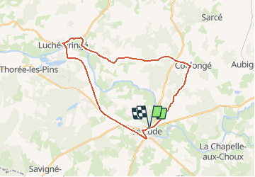
Ruta Bicicleta de 28 km a descubrir en Países del Loira, Sarthe, Le Lude. Esta ruta ha sido propuesta por tracegps.
Descripción
A partir du Lude, on emprunte la voie verte qui relie Luché Pringé. Bel itinéraire entre forêt et bocage. D’autres infos sur le site des Voies Vertes
Localización
País:
France
Región :
Países del Loira
Departamento/provincia :
Sarthe
Municipio :
Le Lude
Localidad:
Le Lude
Salida:(Dec)
Salida:(UTM)
286727 ; 5281111 (31T) N.
Comentarios
Excursiones cerca
![Excursión Carrera Le Lude - Le Lude - Luché - Coulongé - Photo](https://media.geolcdn.com/t/375/260/ext.jpg?maxdim=2&url=https%3A%2F%2Fservices.sitytrail.com%2FGeolivesWS%2FDownloadMedia.ashx%3FTrailID%3D102196%26Media%3D2595_1.jpg)
![Carrera Carrera](https://static1.geolcdn.com/sitytour/trail-icons/103.png)
Le Lude - Luché - Coulongé
Carrera
Difícil
Le Lude,
Países del Loira,
Sarthe,
France
![](/images/other/stat-length.png)
28 km | 31 km-effort
2h 30min
![](https://static1.geolcdn.com/siteimages/upload/files/16400158638029165_repeat_loop_refresh_sync_direction_icon.png)
Sí
![Excursión Bici eléctrica Le Lude - Le Lude - La Mans-18745742 - Photo](https://media.geolcdn.com/t/375/260/ext.jpg?maxdim=2&url=https%3A%2F%2Fstatic1.geolcdn.com%2Fsiteimages%2Fupload%2Ffiles%2F1524743154velo.jpg)
![Bici eléctrica Bici eléctrica](https://static1.geolcdn.com/sitytour/trail-icons/205.png)
Le Lude - La Mans-18745742
Bici eléctrica
Muy fácil
Le Lude,
Países del Loira,
Sarthe,
France
![](/images/other/stat-length.png)
51 km | 57 km-effort
Desconocido
![](https://static1.geolcdn.com/siteimages/upload/files/16400158638029165_repeat_loop_refresh_sync_direction_icon.png)
No
![Excursión Bici de carretera Le Lude - 2nov - Photo](https://media.geolcdn.com/t/375/260/ext.jpg?maxdim=2&url=https%3A%2F%2Fstatic1.geolcdn.com%2Fsiteimages%2Fupload%2Ffiles%2F1524743154velo.jpg)
![Bici de carretera Bici de carretera](https://static1.geolcdn.com/sitytour/trail-icons/201.png)
![Excursión Senderismo Le Lude - 2019-08-18 - Photo](https://media.geolcdn.com/t/375/260/ext.jpg?maxdim=2&url=https%3A%2F%2Fstatic1.geolcdn.com%2Fsiteimages%2Fupload%2Ffiles%2F1553511878bg_sport_marche.png)
![Senderismo Senderismo](https://static1.geolcdn.com/sitytour/trail-icons/101.png)
2019-08-18
Senderismo
Medio
Le Lude,
Países del Loira,
Sarthe,
France
![](/images/other/stat-length.png)
10,9 km | 12,6 km-effort
2h 58min
![](https://static1.geolcdn.com/siteimages/upload/files/16400158638029165_repeat_loop_refresh_sync_direction_icon.png)
No
![Excursión Senderismo Le Lude - luble - Photo](https://media.geolcdn.com/t/375/260/ext.jpg?maxdim=2&url=https%3A%2F%2Fstatic1.geolcdn.com%2Fsiteimages%2Fupload%2Ffiles%2F1553511878bg_sport_marche.png)
![Senderismo Senderismo](https://static1.geolcdn.com/sitytour/trail-icons/101.png)
luble
Senderismo
Muy fácil
Le Lude,
Países del Loira,
Sarthe,
France
![](/images/other/stat-length.png)
22 km | 25 km-effort
2h 48min
![](https://static1.geolcdn.com/siteimages/upload/files/16400158638029165_repeat_loop_refresh_sync_direction_icon.png)
No
![Excursión Senderismo Le Lude - noyant - Photo](https://media.geolcdn.com/t/375/260/ext.jpg?maxdim=2&url=https%3A%2F%2Fstatic1.geolcdn.com%2Fsiteimages%2Fupload%2Ffiles%2F1553511878bg_sport_marche.png)
![Senderismo Senderismo](https://static1.geolcdn.com/sitytour/trail-icons/101.png)
noyant
Senderismo
Muy fácil
Le Lude,
Países del Loira,
Sarthe,
France
![](/images/other/stat-length.png)
27 km | 31 km-effort
6h 43min
![](https://static1.geolcdn.com/siteimages/upload/files/16400158638029165_repeat_loop_refresh_sync_direction_icon.png)
No