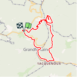
![](/images/other/stat-length.png)
![Excursión Senderismo Grandfontaine - le Donon et petit Donon - Photo](https://media.geolcdn.com/t/1900/400/ext.pjpeg?maxdim=2&url=https%3A%2F%2Fstatic1.geolcdn.com%2Fsiteimages%2Fupload%2Ffiles%2F1553511878bg_sport_marche.png)
le Donon et petit Donon
grattounette
Usuario
![Longitud](/images/other/stat-length.png)
![Altitud máxima](https://static1.geolcdn.com/siteimages/upload/files/1508320355ic_sort_altitude_max_24dp.png)
![Desnivel positivo](https://static1.geolcdn.com/siteimages/upload/files/1508320355ic_sort_den_pos_24dp.png)
![Km-Effort](/images/other/stat-length.png)
![Altitud mínima](https://static1.geolcdn.com/siteimages/upload/files/1508320355ic_sort_altitude_min_24dp.png)
![Desnivel negativo](https://static1.geolcdn.com/siteimages/upload/files/1508320355ic_sort_den_neg_24dp.png)
![Boucle](https://static1.geolcdn.com/siteimages/upload/files/16400158638029165_repeat_loop_refresh_sync_direction_icon.png)
![Senderismo](https://static1.geolcdn.com/sitytour/trail-icons/101.png)
7h10
Dificultad : Difícil
![Escanee este código QR para abrir la excursión en la aplicación SityTrail](https://capi.geolives.com/qq0zvz2zws4bq2lad0pu/sitytour/trails/1021902/qr.png?size=200)
Aplicación GPS de excursión GRATIS
A propósito
Ruta Senderismo de 16,7 km a descubrir en Gran Este, Bajo-Rin, Grandfontaine. Esta ruta ha sido propuesta por grattounette.
Descripción
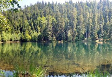
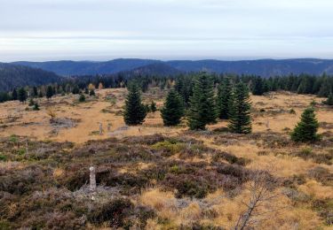
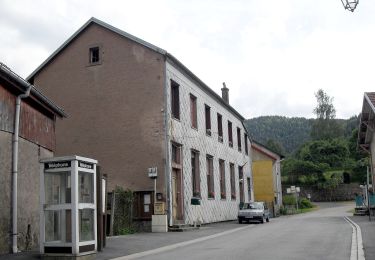
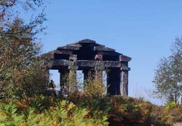
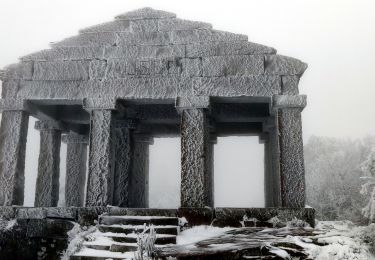
départ du parking du haut Donon en direction du temple romain par un magnifique chemin , arrivé sur les vestiges gallo-romain avec une vue sur le temple on se croirait arrivé a Athènes !!!, puis redescendre au col entre les deux Donon monté au petit Donon voir les Stèles et son point de vue ,faire le tour du petit Donon repassé au Col et descendre en direction du village de Wackenbach remonté par le GR5 passage par le village de Grandfontaine et retour par la maison forestière du Donon
Localización
Comentarios
Excursiones cerca
![Excursión Senderismo Grandfontaine - Donon sentier des casemates - sud - Photo](https://media.geolcdn.com/t/375/260/ext.jpg?maxdim=2&url=https%3A%2F%2Fservices.sitytrail.com%2FGeolivesWS%2FDownloadMedia.ashx%3FTrailID%3D425613%26Media%3Dfix__20150525151051.jpg)
![Senderismo Senderismo](https://static1.geolcdn.com/sitytour/trail-icons/101.png)
Senderismo
![](/images/other/stat-length.png)
![](https://static1.geolcdn.com/siteimages/upload/files/16400158638029165_repeat_loop_refresh_sync_direction_icon.png)
![Excursión Senderismo Grandfontaine - Le site des 2 Donons - Photo](https://media.geolcdn.com/t/375/260/ext.jpg?maxdim=2&url=https%3A%2F%2Fservices.sitytrail.com%2FGeolivesWS%2FDownloadMedia.ashx%3FTrailID%3D201800%26Media%3Db0bd3bee-6dac-4758-b3d3-2df255aa81ea.jpeg)
![Senderismo Senderismo](https://static1.geolcdn.com/sitytour/trail-icons/101.png)
Senderismo
![](/images/other/stat-length.png)
![](https://static1.geolcdn.com/siteimages/upload/files/16400158638029165_repeat_loop_refresh_sync_direction_icon.png)
![Excursión Senderismo Moussey - Col de Prayé - Photo](https://media.geolcdn.com/t/375/260/ext.jpg?maxdim=2&url=https%3A%2F%2Fservices.sitytrail.com%2FGeolivesWS%2FDownloadMedia.ashx%3FTrailID%3D199313%26Media%3D9ff361be-ea22-414c-86b5-f009d7dbf8c7.jpeg)
![Senderismo Senderismo](https://static1.geolcdn.com/sitytour/trail-icons/101.png)
Senderismo
![](/images/other/stat-length.png)
![](https://static1.geolcdn.com/siteimages/upload/files/16400158638029165_repeat_loop_refresh_sync_direction_icon.png)
![Excursión Senderismo La Broque - suuntoapp-Hiking-2024-03-17T08-46-21Z - Photo](https://media.geolcdn.com/t/375/260/ff165b4c-164b-4845-8566-1950893def08.jpg&format=jpg&maxdim=2)
![Senderismo Senderismo](https://static1.geolcdn.com/sitytour/trail-icons/101.png)
Senderismo
![](/images/other/stat-length.png)
![](https://static1.geolcdn.com/siteimages/upload/files/16400158638029165_repeat_loop_refresh_sync_direction_icon.png)
![Excursión Senderismo Grandfontaine - 2023-05-29 Marche Les Minières Lac de la Maix - Photo](https://media.geolcdn.com/t/375/260/eeaa3a18-ae90-480e-a19f-08ce9b6e70fb.jpg&format=jpg&maxdim=2)
![Senderismo Senderismo](https://static1.geolcdn.com/sitytour/trail-icons/101.png)
Senderismo
![](/images/other/stat-length.png)
![](https://static1.geolcdn.com/siteimages/upload/files/16400158638029165_repeat_loop_refresh_sync_direction_icon.png)
![Excursión Senderismo Grandfontaine - 2022-11-12 Marche Grandfontaine Tête Mathis Col de Praye La Corbeille - Photo](https://media.geolcdn.com/t/375/260/b167e9d9-cb78-437f-9a9a-00585292dbd2.jpg&format=jpg&maxdim=2)
![Senderismo Senderismo](https://static1.geolcdn.com/sitytour/trail-icons/101.png)
Senderismo
![](/images/other/stat-length.png)
![](https://static1.geolcdn.com/siteimages/upload/files/16400158638029165_repeat_loop_refresh_sync_direction_icon.png)
![Excursión A pie Grandfontaine - Circuit du Chemin d'Allemagne - Photo](https://media.geolcdn.com/t/375/260/d97b757e-2993-4139-a2d2-59b8ba5b2377.jpeg&format=jpg&maxdim=2)
![A pie A pie](https://static1.geolcdn.com/sitytour/trail-icons/100.png)
A pie
![](/images/other/stat-length.png)
![](https://static1.geolcdn.com/siteimages/upload/files/16400158638029165_repeat_loop_refresh_sync_direction_icon.png)
![Excursión Senderismo Grandfontaine - 2020-09-20 Marche Donon Petit Donon Casemates - Photo](https://media.geolcdn.com/t/375/260/2db16bda-ff7d-4e64-8ae1-49b9c77c7df1.jpg&format=jpg&maxdim=2)
![Senderismo Senderismo](https://static1.geolcdn.com/sitytour/trail-icons/101.png)
Senderismo
![](/images/other/stat-length.png)
![](https://static1.geolcdn.com/siteimages/upload/files/16400158638029165_repeat_loop_refresh_sync_direction_icon.png)
![Excursión Senderismo Grandfontaine - 2019-01-05 Marche Temple du Donon - Photo](https://media.geolcdn.com/t/375/260/4d10af06-75fc-4752-bbdb-0324344fa64e.jpg&format=jpg&maxdim=2)
![Senderismo Senderismo](https://static1.geolcdn.com/sitytour/trail-icons/101.png)
Senderismo
![](/images/other/stat-length.png)
![](https://static1.geolcdn.com/siteimages/upload/files/16400158638029165_repeat_loop_refresh_sync_direction_icon.png)