![](/images/other/stat-length.png)
![Excursión Bici de montaña Chabreloche - Espace VTT FFC du Massif des Bois-Noirs - Circuit n° 21 - Le Roc du Guet - Photo](https://media.geolcdn.com/t/1900/400/ext.pjpeg?maxdim=2&url=https%3A%2F%2Fservices.sitytrail.com%2FGeolivesWS%2FDownloadMedia.ashx%3FTrailID%3D102098%26Media%3D2480_2.jpg)
Espace VTT FFC du Massif des Bois-Noirs - Circuit n° 21 - Le Roc du Guet
tracegps
Usuario
![Longitud](/images/other/stat-length.png)
![Altitud máxima](https://static1.geolcdn.com/siteimages/upload/files/1508320355ic_sort_altitude_max_24dp.png)
![Desnivel positivo](https://static1.geolcdn.com/siteimages/upload/files/1508320355ic_sort_den_pos_24dp.png)
![Km-Effort](/images/other/stat-length.png)
![Altitud mínima](https://static1.geolcdn.com/siteimages/upload/files/1508320355ic_sort_altitude_min_24dp.png)
![Desnivel negativo](https://static1.geolcdn.com/siteimages/upload/files/1508320355ic_sort_den_neg_24dp.png)
![Boucle](https://static1.geolcdn.com/siteimages/upload/files/16400158638029165_repeat_loop_refresh_sync_direction_icon.png)
![Bici de montaña](https://static1.geolcdn.com/sitytour/trail-icons/202.png)
2h00
Dificultad : Difícil
![Escanee este código QR para abrir la excursión en la aplicación SityTrail](https://capi.geolives.com/qq0zvz2zws4bq2lad0pu/sitytour/trails/102098/qr.png?size=200)
Aplicación GPS de excursión GRATIS
A propósito
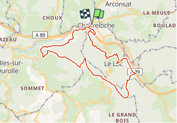
Ruta Bici de montaña de 18,8 km a descubrir en Auvergne-Rhône-Alpes, Puy-de-Dôme, Chabreloche. Esta ruta ha sido propuesta por tracegps.
Descripción
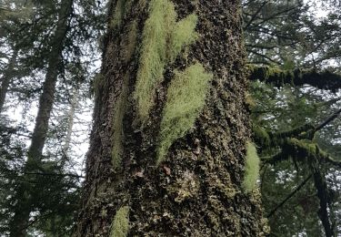
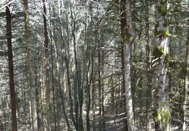
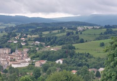
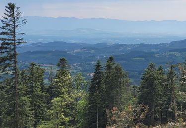
Circuit labellisé par la Fédération Française de Cyclisme. Chabreloche est une petite cité de la montagne Thiernoise, située aux portes du Forez et de l’Auvergne qui a su garder son charme authentique fait de bonhomie et de bon vivre. Le Roc du Guet est un lieu éminent d’où l’on peut regarder (gueità) au loin à 912 m d’altitude.
Localización
Comentarios
Excursiones cerca
![Excursión Senderismo Arconsat - Col de la Charme - Photo](https://media.geolcdn.com/t/375/260/83cd7712-19e5-489a-bc72-c7327eb4a13c.jpg&format=jpg&maxdim=2)
![Senderismo Senderismo](https://static1.geolcdn.com/sitytour/trail-icons/101.png)
Senderismo
![](/images/other/stat-length.png)
![](https://static1.geolcdn.com/siteimages/upload/files/16400158638029165_repeat_loop_refresh_sync_direction_icon.png)
![Excursión A pie Arconsat - Montlune - Photo](https://media.geolcdn.com/t/375/260/c657d6f2-0003-4090-a052-219487f3be3a.jpeg&format=jpg&maxdim=2)
![A pie A pie](https://static1.geolcdn.com/sitytour/trail-icons/100.png)
A pie
![](/images/other/stat-length.png)
![](https://static1.geolcdn.com/siteimages/upload/files/16400158638029165_repeat_loop_refresh_sync_direction_icon.png)
![Excursión Senderismo Saint-Priest-la-Prugne - Col de la Charme - Photo](https://media.geolcdn.com/t/375/260/7482aed9-3f58-400d-95c6-5af863d7ad1a.jpg&format=jpg&maxdim=2)
![Senderismo Senderismo](https://static1.geolcdn.com/sitytour/trail-icons/101.png)
Senderismo
![](/images/other/stat-length.png)
![](https://static1.geolcdn.com/siteimages/upload/files/16400158638029165_repeat_loop_refresh_sync_direction_icon.png)
![Excursión Senderismo Saint-Priest-la-Prugne - Col de la Charme 2020 - Photo](https://media.geolcdn.com/t/375/260/db673239-bfc6-461b-a458-7aa5bd1e7c98.jpg&format=jpg&maxdim=2)
![Senderismo Senderismo](https://static1.geolcdn.com/sitytour/trail-icons/101.png)
Senderismo
![](/images/other/stat-length.png)
![](https://static1.geolcdn.com/siteimages/upload/files/16400158638029165_repeat_loop_refresh_sync_direction_icon.png)
![Senderismo Senderismo](https://static1.geolcdn.com/sitytour/trail-icons/101.png)
Senderismo
![](/images/other/stat-length.png)
![](https://static1.geolcdn.com/siteimages/upload/files/16400158638029165_repeat_loop_refresh_sync_direction_icon.png)
![Excursión Senderismo Chausseterre - retour TOP 03 - Photo](https://media.geolcdn.com/t/375/260/0e639819-d824-4c70-9258-9551f02b9c2e.jpg&format=jpg&maxdim=2)
![Senderismo Senderismo](https://static1.geolcdn.com/sitytour/trail-icons/101.png)
Senderismo
![](/images/other/stat-length.png)
![](https://static1.geolcdn.com/siteimages/upload/files/16400158638029165_repeat_loop_refresh_sync_direction_icon.png)
![Excursión Senderismo Celles-sur-Durolle - Le Puy de Montoncel_T - Photo](https://media.geolcdn.com/t/375/260/d73873a8-736e-4bf5-9cdb-da7751bfb868.jpg&format=jpg&maxdim=2)
![Senderismo Senderismo](https://static1.geolcdn.com/sitytour/trail-icons/101.png)
Senderismo
![](/images/other/stat-length.png)
![](https://static1.geolcdn.com/siteimages/upload/files/16400158638029165_repeat_loop_refresh_sync_direction_icon.png)
![Excursión A pie Chabreloche - Le Roc du Guet - Photo](https://media.geolcdn.com/t/375/260/ext.jpg?maxdim=2&url=https%3A%2F%2Fstatic1.geolcdn.com%2Fsiteimages%2Fupload%2Ffiles%2F1545311037marcheuse_200dpi.jpg)
![A pie A pie](https://static1.geolcdn.com/sitytour/trail-icons/100.png)
A pie
![](/images/other/stat-length.png)
![](https://static1.geolcdn.com/siteimages/upload/files/16400158638029165_repeat_loop_refresh_sync_direction_icon.png)
![Excursión Senderismo Chabreloche - Chabreloche_Roc_Guet_1 - Photo](https://media.geolcdn.com/t/375/260/6e9d5269-2e1d-4a00-95e3-9a384f7782a1.jpg&format=jpg&maxdim=2)
![Senderismo Senderismo](https://static1.geolcdn.com/sitytour/trail-icons/101.png)
Senderismo
![](/images/other/stat-length.png)
![](https://static1.geolcdn.com/siteimages/upload/files/16400158638029165_repeat_loop_refresh_sync_direction_icon.png)