![](/images/other/stat-length.png)
![Excursión Senderismo Izieu - Par Lambra et la Contamine, Izieu - Photo](https://media.geolcdn.com/t/1900/400/ext.pjpeg?maxdim=2&url=https%3A%2F%2Fservices.sitytrail.com%2FGeolivesWS%2FDownloadMedia.ashx%3FTrailID%3D102078%26Media%3D2437_1.jpg)
Par Lambra et la Contamine, Izieu
tracegps
Usuario
![Longitud](/images/other/stat-length.png)
![Altitud máxima](https://static1.geolcdn.com/siteimages/upload/files/1508320355ic_sort_altitude_max_24dp.png)
![Desnivel positivo](https://static1.geolcdn.com/siteimages/upload/files/1508320355ic_sort_den_pos_24dp.png)
![Km-Effort](/images/other/stat-length.png)
![Altitud mínima](https://static1.geolcdn.com/siteimages/upload/files/1508320355ic_sort_altitude_min_24dp.png)
![Desnivel negativo](https://static1.geolcdn.com/siteimages/upload/files/1508320355ic_sort_den_neg_24dp.png)
![Boucle](https://static1.geolcdn.com/siteimages/upload/files/16400158638029165_repeat_loop_refresh_sync_direction_icon.png)
![Senderismo](https://static1.geolcdn.com/sitytour/trail-icons/101.png)
1h30
Dificultad : Medio
![Escanee este código QR para abrir la excursión en la aplicación SityTrail](https://capi.geolives.com/qq0zvz2zws4bq2lad0pu/sitytour/trails/102078/qr.png?size=200)
Aplicación GPS de excursión GRATIS
A propósito
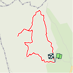
Ruta Senderismo de 4,6 km a descubrir en Auvergne-Rhône-Alpes, Ain, Izieu. Esta ruta ha sido propuesta por tracegps.
Descripción
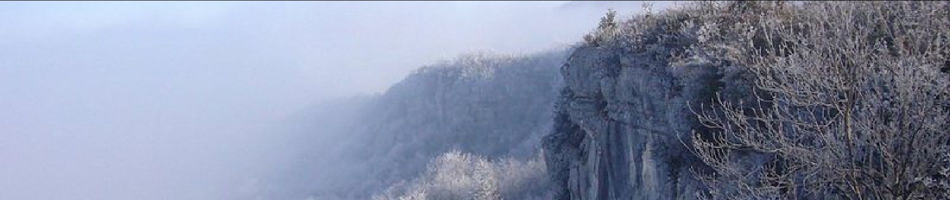
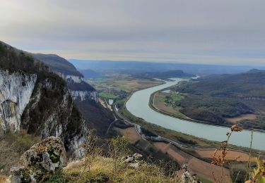
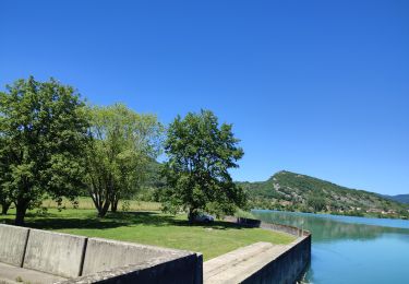
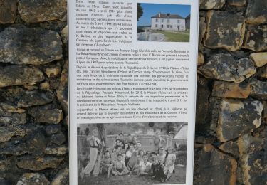
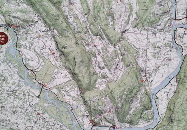
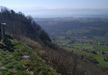
Ce coin de la campagne des environs d'Izieu est riche de sentiers oubliés peu fréquentés. Cette boucle originale permet de découvrir le Creux-Vinçon, et en passant dans le versant Ouest du plateau de Cherva de traverser le site de l'ancienne ferme de Lambra. La promenade se poursuivra en montant vers la Contamine et si l'on emprunte un vieux sentier, on pourra atteindre un point de vue improbable sur le site de Lambra et le Grand Thur au bord d'une falaise avant de rattraper la descente de la Croix de Saint-Clair déjà décrite. Description complète sur sentier-nature.com : Par Lambra et la Contamine, Izieu
Localización
Comentarios
Excursiones cerca
![Excursión Motor Arboys-en-Bugey - Rando remise en forme - Photo](https://media.geolcdn.com/t/375/260/ext.jpg?maxdim=2&url=https%3A%2F%2Fstatic1.geolcdn.com%2Fsiteimages%2Fupload%2Ffiles%2F15247431544x4.jpg)
![Motor Motor](https://static1.geolcdn.com/sitytour/trail-icons/400.png)
Motor
![](/images/other/stat-length.png)
![](https://static1.geolcdn.com/siteimages/upload/files/16400158638029165_repeat_loop_refresh_sync_direction_icon.png)
![Excursión Senderismo Saint-Genix-les-Villages - 73_gresin_montTournier_18km_630 - Photo](https://media.geolcdn.com/t/375/260/8cc10b7c-be8e-494b-84e7-db8c7dc80b3c.jpg&format=jpg&maxdim=2)
![Senderismo Senderismo](https://static1.geolcdn.com/sitytour/trail-icons/101.png)
Senderismo
![](/images/other/stat-length.png)
![](https://static1.geolcdn.com/siteimages/upload/files/16400158638029165_repeat_loop_refresh_sync_direction_icon.png)
![Excursión Paseo ecuestre Peyrieu - peyrieu Izieu valide cavaliersp - Photo](https://media.geolcdn.com/t/375/260/2c32351f-e06a-4a02-927a-937d3ed0c61b.jpg&format=jpg&maxdim=2)
![Paseo ecuestre Paseo ecuestre](https://static1.geolcdn.com/sitytour/trail-icons/301.png)
Paseo ecuestre
![](/images/other/stat-length.png)
![](https://static1.geolcdn.com/siteimages/upload/files/16400158638029165_repeat_loop_refresh_sync_direction_icon.png)
![Excursión Senderismo Saint-Genix-les-Villages - Mont Tournier - Photo](https://media.geolcdn.com/t/375/260/ca4047a9-59c8-4dcf-93d3-127eea8f1a84.jpg&format=jpg&maxdim=2)
![Senderismo Senderismo](https://static1.geolcdn.com/sitytour/trail-icons/101.png)
Senderismo
![](/images/other/stat-length.png)
![](https://static1.geolcdn.com/siteimages/upload/files/16400158638029165_repeat_loop_refresh_sync_direction_icon.png)
![Excursión Paseo ecuestre Champagneux - 202206 boucle Gourjux - Photo](https://media.geolcdn.com/t/375/260/c8713771-86f9-46ed-8bc5-7397cec70731.jpg&format=jpg&maxdim=2)
![Paseo ecuestre Paseo ecuestre](https://static1.geolcdn.com/sitytour/trail-icons/301.png)
Paseo ecuestre
![](/images/other/stat-length.png)
![](https://static1.geolcdn.com/siteimages/upload/files/16400158638029165_repeat_loop_refresh_sync_direction_icon.png)
![Excursión Senderismo Brégnier-Cordon - Cascade de glandieu, grand Thur en boucle dans l'Ain - Photo](https://media.geolcdn.com/t/375/260/1036fcd4-7da6-4120-94e4-e224fe2ab54b.jpg&format=jpg&maxdim=2)
![Senderismo Senderismo](https://static1.geolcdn.com/sitytour/trail-icons/101.png)
Senderismo
![](/images/other/stat-length.png)
![](https://static1.geolcdn.com/siteimages/upload/files/16400158638029165_repeat_loop_refresh_sync_direction_icon.png)
![Excursión Bicicleta híbrida Brégnier-Cordon - 01-vtt-viarhona-Bregnier-Cordon-2-boucles 30km et 20km - Photo](https://media.geolcdn.com/t/375/260/e2a45222-1cf4-421d-9652-5fba85609478.jpg&format=jpg&maxdim=2)
![Bicicleta híbrida Bicicleta híbrida](https://static1.geolcdn.com/sitytour/trail-icons/203.png)
Bicicleta híbrida
![](/images/other/stat-length.png)
![](https://static1.geolcdn.com/siteimages/upload/files/16400158638029165_repeat_loop_refresh_sync_direction_icon.png)
![Excursión Senderismo Saint-Genix-les-Villages - le monts tournier - Photo](https://media.geolcdn.com/t/375/260/73dd6fc7-d7b7-4eb8-83b7-c2dd469235a5.jpg&format=jpg&maxdim=2)
![Senderismo Senderismo](https://static1.geolcdn.com/sitytour/trail-icons/101.png)
Senderismo
![](/images/other/stat-length.png)
![](https://static1.geolcdn.com/siteimages/upload/files/16400158638029165_repeat_loop_refresh_sync_direction_icon.png)
![Excursión Bici de montaña Peyrieu - Sur Fays - Photo](https://media.geolcdn.com/t/375/260/bba9d891-7509-4cec-84db-7eb740a87a92.jpg&format=jpg&maxdim=2)
![Bici de montaña Bici de montaña](https://static1.geolcdn.com/sitytour/trail-icons/202.png)
Bici de montaña
![](/images/other/stat-length.png)
![](https://static1.geolcdn.com/siteimages/upload/files/16400158638029165_repeat_loop_refresh_sync_direction_icon.png)