![](/images/other/stat-length.png)
![Excursión Senderismo Saint-Saturnin - La montagne de la Serre - Photo](https://media.geolcdn.com/t/1900/400/ext.pjpeg?maxdim=2&url=https%3A%2F%2Fservices.sitytrail.com%2FGeolivesWS%2FDownloadMedia.ashx%3FTrailID%3D101863%26Media%3D2149_2.jpg)
La montagne de la Serre
tracegps
Usuario
![Longitud](/images/other/stat-length.png)
Longitud
9,5 km
![Altitud máxima](https://static1.geolcdn.com/siteimages/upload/files/1508320355ic_sort_altitude_max_24dp.png)
Altitud máxima
735 m
![Desnivel positivo](https://static1.geolcdn.com/siteimages/upload/files/1508320355ic_sort_den_pos_24dp.png)
Desnivel positivo
231 m
![Km-Effort](/images/other/stat-length.png)
Km-Effort
12,6 km
![Altitud mínima](https://static1.geolcdn.com/siteimages/upload/files/1508320355ic_sort_altitude_min_24dp.png)
Altitud mínima
595 m
![Desnivel negativo](https://static1.geolcdn.com/siteimages/upload/files/1508320355ic_sort_den_neg_24dp.png)
Desnivel negativo
230 m
![Boucle](https://static1.geolcdn.com/siteimages/upload/files/16400158638029165_repeat_loop_refresh_sync_direction_icon.png)
Boucle
Sí
Fecha de creación :
2014-12-10 00:00:00.0
Última modificación :
2014-12-10 00:00:00.0
![Senderismo](https://static1.geolcdn.com/sitytour/trail-icons/101.png)
2h45
Dificultad : Medio
![Escanee este código QR para abrir la excursión en la aplicación SityTrail](https://capi.geolives.com/qq0zvz2zws4bq2lad0pu/sitytour/trails/101863/qr.png?size=200)
Aplicación GPS de excursión GRATIS
A propósito
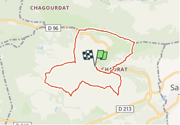
Ruta Senderismo de 9,5 km a descubrir en Auvergne-Rhône-Alpes, Puy-de-Dôme, Saint-Saturnin. Esta ruta ha sido propuesta por tracegps.
Descripción
Balade numérisée sur le terrain par Jean louis Phillipart. Retrouvez cette randonnée dans le topo Guide Chamina Chaîne des Puys.
Localización
País:
France
Región :
Auvergne-Rhône-Alpes
Departamento/provincia :
Puy-de-Dôme
Municipio :
Saint-Saturnin
Localidad:
Unknown
Salida:(Dec)
Salida:(UTM)
505876 ; 5057967 (31T) N.
Comentarios
Excursiones cerca
![Excursión Senderismo Romagnat - Le Puy Giroux près d'Opme - Photo](https://media.geolcdn.com/t/375/260/ext.jpg?maxdim=2&url=https%3A%2F%2Fservices.sitytrail.com%2FGeolivesWS%2FDownloadMedia.ashx%3FTrailID%3D107482%26Media%3D12426_1.jpg)
![Senderismo Senderismo](https://static1.geolcdn.com/sitytour/trail-icons/101.png)
Le Puy Giroux près d'Opme
Senderismo
Fácil
(1)
Romagnat,
Auvergne-Rhône-Alpes,
Puy-de-Dôme,
France
![](/images/other/stat-length.png)
6,6 km | 9,2 km-effort
1h 45min
![](https://static1.geolcdn.com/siteimages/upload/files/16400158638029165_repeat_loop_refresh_sync_direction_icon.png)
Sí
![Excursión A pie Saint-Saturnin - Randol - Photo](https://media.geolcdn.com/t/375/260/9e85dae3-ad96-41f9-a960-52d6d206727c.jpeg&format=jpg&maxdim=2)
![A pie A pie](https://static1.geolcdn.com/sitytour/trail-icons/100.png)
Randol
A pie
Fácil
(1)
Saint-Saturnin,
Auvergne-Rhône-Alpes,
Puy-de-Dôme,
France
![](/images/other/stat-length.png)
7,8 km | 10,6 km-effort
2h 24min
![](https://static1.geolcdn.com/siteimages/upload/files/16400158638029165_repeat_loop_refresh_sync_direction_icon.png)
Sí
![Excursión A pie Saint-Saturnin - Les Cirques de longevette et des Cotes - Photo](https://media.geolcdn.com/t/375/260/35f5865b-8ac0-4231-943a-09bc6fa13964.jpeg&format=jpg&maxdim=2)
![A pie A pie](https://static1.geolcdn.com/sitytour/trail-icons/100.png)
Les Cirques de longevette et des Cotes
A pie
Fácil
Saint-Saturnin,
Auvergne-Rhône-Alpes,
Puy-de-Dôme,
France
![](/images/other/stat-length.png)
5,4 km | 7,1 km-effort
1h 37min
![](https://static1.geolcdn.com/siteimages/upload/files/16400158638029165_repeat_loop_refresh_sync_direction_icon.png)
Sí
![Excursión A pie Saint-Amant-Tallende - Le Puy de Peyronere - Photo](https://media.geolcdn.com/t/375/260/a5859447-4468-4d79-8d71-76c1effac2f0.jpeg&format=jpg&maxdim=2)
![A pie A pie](https://static1.geolcdn.com/sitytour/trail-icons/100.png)
Le Puy de Peyronere
A pie
Fácil
Saint-Amant-Tallende,
Auvergne-Rhône-Alpes,
Puy-de-Dôme,
France
![](/images/other/stat-length.png)
9,5 km | 13 km-effort
2h 57min
![](https://static1.geolcdn.com/siteimages/upload/files/16400158638029165_repeat_loop_refresh_sync_direction_icon.png)
Sí
![Excursión A pie Saint-Genès-Champanelle - Nadaillat - Photo](https://media.geolcdn.com/t/375/260/f63239da-1e27-43d7-84c3-ba50289c6d9e.jpeg&format=jpg&maxdim=2)
![A pie A pie](https://static1.geolcdn.com/sitytour/trail-icons/100.png)
Nadaillat
A pie
Fácil
Saint-Genès-Champanelle,
Auvergne-Rhône-Alpes,
Puy-de-Dôme,
France
![](/images/other/stat-length.png)
6,6 km | 9,3 km-effort
2h 7min
![](https://static1.geolcdn.com/siteimages/upload/files/16400158638029165_repeat_loop_refresh_sync_direction_icon.png)
Sí
![Excursión A pie Chanonat - Le Crest - Photo](https://media.geolcdn.com/t/375/260/c9b3d1da-554f-4873-8d44-afc3e6570967.jpeg&format=jpg&maxdim=2)
![A pie A pie](https://static1.geolcdn.com/sitytour/trail-icons/100.png)
Le Crest
A pie
Fácil
Chanonat,
Auvergne-Rhône-Alpes,
Puy-de-Dôme,
France
![](/images/other/stat-length.png)
10,7 km | 14,7 km-effort
3h 20min
![](https://static1.geolcdn.com/siteimages/upload/files/16400158638029165_repeat_loop_refresh_sync_direction_icon.png)
Sí
![Excursión A pie Chanonat - Le Puy de Jussat - Photo](https://media.geolcdn.com/t/375/260/73982e6a-da33-4176-a420-7d563bd2d917.jpeg&format=jpg&maxdim=2)
![A pie A pie](https://static1.geolcdn.com/sitytour/trail-icons/100.png)
Le Puy de Jussat
A pie
Fácil
Chanonat,
Auvergne-Rhône-Alpes,
Puy-de-Dôme,
France
![](/images/other/stat-length.png)
4,7 km | 6,8 km-effort
1h 32min
![](https://static1.geolcdn.com/siteimages/upload/files/16400158638029165_repeat_loop_refresh_sync_direction_icon.png)
Sí
![Excursión Senderismo Saint-Saturnin - St saturnin - Photo](https://media.geolcdn.com/t/375/260/ext.jpg?maxdim=2&url=https%3A%2F%2Fstatic1.geolcdn.com%2Fsiteimages%2Fupload%2Ffiles%2F1553511878bg_sport_marche.png)
![Senderismo Senderismo](https://static1.geolcdn.com/sitytour/trail-icons/101.png)
St saturnin
Senderismo
Muy fácil
(1)
Saint-Saturnin,
Auvergne-Rhône-Alpes,
Puy-de-Dôme,
France
![](/images/other/stat-length.png)
15,7 km | 21 km-effort
4h 29min
![](https://static1.geolcdn.com/siteimages/upload/files/16400158638029165_repeat_loop_refresh_sync_direction_icon.png)
Sí
![Excursión Senderismo Ceyrat - Les trois moulins - Ceyrat - Photo](https://media.geolcdn.com/t/375/260/ext.jpg?maxdim=2&url=https%3A%2F%2Fstatic1.geolcdn.com%2Fsiteimages%2Fupload%2Ffiles%2F1553511878bg_sport_marche.png)
![Senderismo Senderismo](https://static1.geolcdn.com/sitytour/trail-icons/101.png)
Les trois moulins - Ceyrat
Senderismo
Difícil
(1)
Ceyrat,
Auvergne-Rhône-Alpes,
Puy-de-Dôme,
France
![](/images/other/stat-length.png)
21 km | 28 km-effort
6h 0min
![](https://static1.geolcdn.com/siteimages/upload/files/16400158638029165_repeat_loop_refresh_sync_direction_icon.png)
Sí