![](/images/other/stat-length.png)
![Excursión Senderismo Authezat - Les forts de la Sauvetat - Photo](https://media.geolcdn.com/t/1900/400/ext.pjpeg?maxdim=2&url=https%3A%2F%2Fservices.sitytrail.com%2FGeolivesWS%2FDownloadMedia.ashx%3FTrailID%3D101848%26Media%3D2134_1.jpg)
Les forts de la Sauvetat
tracegps
Usuario
![Longitud](/images/other/stat-length.png)
Longitud
7,7 km
![Altitud máxima](https://static1.geolcdn.com/siteimages/upload/files/1508320355ic_sort_altitude_max_24dp.png)
Altitud máxima
432 m
![Desnivel positivo](https://static1.geolcdn.com/siteimages/upload/files/1508320355ic_sort_den_pos_24dp.png)
Desnivel positivo
89 m
![Km-Effort](/images/other/stat-length.png)
Km-Effort
8,9 km
![Altitud mínima](https://static1.geolcdn.com/siteimages/upload/files/1508320355ic_sort_altitude_min_24dp.png)
Altitud mínima
367 m
![Desnivel negativo](https://static1.geolcdn.com/siteimages/upload/files/1508320355ic_sort_den_neg_24dp.png)
Desnivel negativo
89 m
![Boucle](https://static1.geolcdn.com/siteimages/upload/files/16400158638029165_repeat_loop_refresh_sync_direction_icon.png)
Boucle
Sí
Fecha de creación :
2014-12-10 00:00:00.0
Última modificación :
2014-12-10 00:00:00.0
![Senderismo](https://static1.geolcdn.com/sitytour/trail-icons/101.png)
2h15
Dificultad : Difícil
![Escanee este código QR para abrir la excursión en la aplicación SityTrail](https://capi.geolives.com/qq0zvz2zws4bq2lad0pu/sitytour/trails/101848/qr.png?size=200)
Aplicación GPS de excursión GRATIS
A propósito
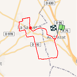
Ruta Senderismo de 7,7 km a descubrir en Auvergne-Rhône-Alpes, Puy-de-Dôme, Authezat. Esta ruta ha sido propuesta por tracegps.
Descripción
Balade numérisée sur le terrain par Jean louis Phillipart. Tout sur les forts de la Sauvetat( source photo). Retrouvez cette randonnée dans le topo Guide Chamina Autour de Clermont.
Localización
País:
France
Región :
Auvergne-Rhône-Alpes
Departamento/provincia :
Puy-de-Dôme
Municipio :
Authezat
Localidad:
Unknown
Salida:(Dec)
Salida:(UTM)
514495 ; 5053326 (31T) N.
Comentarios
Excursiones cerca
![Excursión Senderismo Champeix - Champeix_St_Julien - Photo](https://media.geolcdn.com/t/375/260/42c319f4-7a47-48dd-bf0b-2587fad533a9.jpg&format=jpg&maxdim=2)
![Senderismo Senderismo](https://static1.geolcdn.com/sitytour/trail-icons/101.png)
Champeix_St_Julien
Senderismo
Fácil
(1)
Champeix,
Auvergne-Rhône-Alpes,
Puy-de-Dôme,
France
![](/images/other/stat-length.png)
9,1 km | 12,3 km-effort
2h 45min
![](https://static1.geolcdn.com/siteimages/upload/files/16400158638029165_repeat_loop_refresh_sync_direction_icon.png)
Sí
![Senderismo Senderismo](https://static1.geolcdn.com/sitytour/trail-icons/101.png)
Montpeyroux_Arkose
Senderismo
Fácil
(1)
Montpeyroux,
Auvergne-Rhône-Alpes,
Puy-de-Dôme,
France
![](/images/other/stat-length.png)
8,6 km | 11,2 km-effort
2h 30min
![](https://static1.geolcdn.com/siteimages/upload/files/16400158638029165_repeat_loop_refresh_sync_direction_icon.png)
Sí
![Senderismo Senderismo](https://static1.geolcdn.com/sitytour/trail-icons/101.png)
Authezat Horaire
Senderismo
Medio
(1)
Authezat,
Auvergne-Rhône-Alpes,
Puy-de-Dôme,
France
![](/images/other/stat-length.png)
7,4 km | 8,6 km-effort
2h 45min
![](https://static1.geolcdn.com/siteimages/upload/files/16400158638029165_repeat_loop_refresh_sync_direction_icon.png)
Sí
![Excursión Senderismo Parent - Parent_Montpeyroux - Photo](https://media.geolcdn.com/t/375/260/5d7d75da-6cfd-4cb5-a3d3-b6ff5a686467.jpg&format=jpg&maxdim=2)
![Senderismo Senderismo](https://static1.geolcdn.com/sitytour/trail-icons/101.png)
Parent_Montpeyroux
Senderismo
Medio
(1)
Parent,
Auvergne-Rhône-Alpes,
Puy-de-Dôme,
France
![](/images/other/stat-length.png)
9,8 km | 13,4 km-effort
2h 45min
![](https://static1.geolcdn.com/siteimages/upload/files/16400158638029165_repeat_loop_refresh_sync_direction_icon.png)
Sí
![Excursión Senderismo Vic-le-Comte - Entre vignes et comté - Photo](https://media.geolcdn.com/t/375/260/ext.jpg?maxdim=2&url=https%3A%2F%2Fservices.sitytrail.com%2FGeolivesWS%2FDownloadMedia.ashx%3FTrailID%3D102016%26Media%3D2322_2.jpg)
![Senderismo Senderismo](https://static1.geolcdn.com/sitytour/trail-icons/101.png)
Entre vignes et comté
Senderismo
Medio
(1)
Vic-le-Comte,
Auvergne-Rhône-Alpes,
Puy-de-Dôme,
France
![](/images/other/stat-length.png)
8,6 km | 10,8 km-effort
2h 30min
![](https://static1.geolcdn.com/siteimages/upload/files/16400158638029165_repeat_loop_refresh_sync_direction_icon.png)
Sí
![Excursión A pie Montpeyroux - Montpeyroux - Photo](https://media.geolcdn.com/t/375/260/a7bba57e-1073-43f5-8adc-862b103ee316.jpeg&format=jpg&maxdim=2)
![A pie A pie](https://static1.geolcdn.com/sitytour/trail-icons/100.png)
Montpeyroux
A pie
Fácil
Montpeyroux,
Auvergne-Rhône-Alpes,
Puy-de-Dôme,
France
![](/images/other/stat-length.png)
3,9 km | 5,3 km-effort
1h 12min
![](https://static1.geolcdn.com/siteimages/upload/files/16400158638029165_repeat_loop_refresh_sync_direction_icon.png)
No
![Excursión A pie Authezat - Sur le Chemin de l'Arkose - Photo](https://media.geolcdn.com/t/375/260/f00cf124-c43c-453c-a0c8-824c03b3ba30.jpeg&format=jpg&maxdim=2)
![A pie A pie](https://static1.geolcdn.com/sitytour/trail-icons/100.png)
Sur le Chemin de l'Arkose
A pie
Fácil
Authezat,
Auvergne-Rhône-Alpes,
Puy-de-Dôme,
France
![](/images/other/stat-length.png)
8,7 km | 11,2 km-effort
2h 33min
![](https://static1.geolcdn.com/siteimages/upload/files/16400158638029165_repeat_loop_refresh_sync_direction_icon.png)
Sí
![Excursión A pie Yronde-et-Buron - L'Abbaye du Bouschet - Photo](https://media.geolcdn.com/t/375/260/50cfacdd-f92e-4973-88f2-43faafdab62f.jpeg&format=jpg&maxdim=2)
![A pie A pie](https://static1.geolcdn.com/sitytour/trail-icons/100.png)
L'Abbaye du Bouschet
A pie
Fácil
Yronde-et-Buron,
Auvergne-Rhône-Alpes,
Puy-de-Dôme,
France
![](/images/other/stat-length.png)
10,8 km | 14,8 km-effort
3h 21min
![](https://static1.geolcdn.com/siteimages/upload/files/16400158638029165_repeat_loop_refresh_sync_direction_icon.png)
Sí
![Excursión A pie Yronde-et-Buron - La Citadelle de Buron - Photo](https://media.geolcdn.com/t/375/260/d0b37edd-ef3f-469d-9576-5c41af0df209.jpeg&format=jpg&maxdim=2)
![A pie A pie](https://static1.geolcdn.com/sitytour/trail-icons/100.png)
La Citadelle de Buron
A pie
Fácil
Yronde-et-Buron,
Auvergne-Rhône-Alpes,
Puy-de-Dôme,
France
![](/images/other/stat-length.png)
10,4 km | 15 km-effort
3h 25min
![](https://static1.geolcdn.com/siteimages/upload/files/16400158638029165_repeat_loop_refresh_sync_direction_icon.png)
Sí