![](/images/other/stat-length.png)
![Excursión Carrera Nances - Tour du Lac d'Aiguebelette - Photo](https://media.geolcdn.com/t/1900/400/ext.pjpeg?maxdim=2&url=https%3A%2F%2Fservices.sitytrail.com%2FGeolivesWS%2FDownloadMedia.ashx%3FTrailID%3D101718%26Media%3D1964_1.jpg)
Tour du Lac d'Aiguebelette
tracegps
Usuario
![Longitud](/images/other/stat-length.png)
![Altitud máxima](https://static1.geolcdn.com/siteimages/upload/files/1508320355ic_sort_altitude_max_24dp.png)
![Desnivel positivo](https://static1.geolcdn.com/siteimages/upload/files/1508320355ic_sort_den_pos_24dp.png)
![Km-Effort](/images/other/stat-length.png)
![Altitud mínima](https://static1.geolcdn.com/siteimages/upload/files/1508320355ic_sort_altitude_min_24dp.png)
![Desnivel negativo](https://static1.geolcdn.com/siteimages/upload/files/1508320355ic_sort_den_neg_24dp.png)
![Boucle](https://static1.geolcdn.com/siteimages/upload/files/16400158638029165_repeat_loop_refresh_sync_direction_icon.png)
![Carrera](https://static1.geolcdn.com/sitytour/trail-icons/103.png)
1h30
Dificultad : Medio
![Escanee este código QR para abrir la excursión en la aplicación SityTrail](https://capi.geolives.com/qq0zvz2zws4bq2lad0pu/sitytour/trails/101718/qr.png?size=200)
Aplicación GPS de excursión GRATIS
A propósito
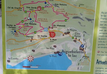
Ruta Carrera de 16,8 km a descubrir en Auvergne-Rhône-Alpes, Saboya, Nances. Esta ruta ha sido propuesta por tracegps.
Descripción
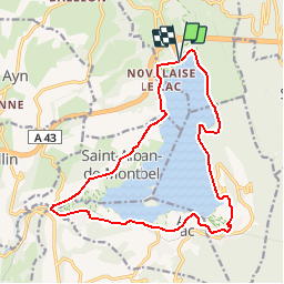
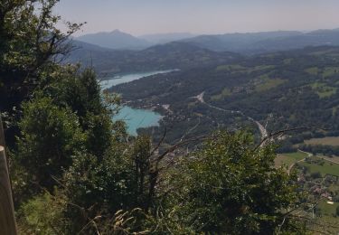
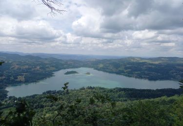
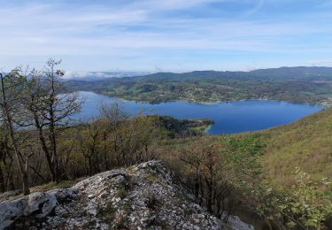
Blotti au creux du dernier chaînon jurassien, à la lisière des pré-Alpes, le Lac d’Aiguebelette, petite perle d’émeraude, vous accueille dans un cadre naturel exceptionnel propice au ressourcement, à la détente et à la pratique des sports et loisirs de pleine nature. 3ème Lac naturel de France par sa taille de 545 hectares, c’est un lac privé qui appartient à la famille de Chambost et à E.D.F. Il est situé en Savoie, au coeur de l'Avant Pays Savoyard et à la porte du Parc Naturel de Chartreuse. (Source Office Tourisme Lac D'Aiguebelette)
Localización
Comentarios
Excursiones cerca
![Excursión Ruta La Motte-Servolex - Château Richard et croix du Signal - Photo](https://media.geolcdn.com/t/375/260/3752241f-e62c-4bc8-86ee-aa981979bc96.jpg&format=jpg&maxdim=2)
![Ruta Ruta](https://static1.geolcdn.com/sitytour/trail-icons/104.png)
Ruta
![](/images/other/stat-length.png)
![](https://static1.geolcdn.com/siteimages/upload/files/16400158638029165_repeat_loop_refresh_sync_direction_icon.png)
![Excursión Senderismo Aiguebelette-le-Lac - Mont grêle - Photo](https://media.geolcdn.com/t/375/260/ext.jpg?maxdim=2&url=https%3A%2F%2Fstatic1.geolcdn.com%2Fsiteimages%2Fupload%2Ffiles%2F1553511878bg_sport_marche.png)
![Senderismo Senderismo](https://static1.geolcdn.com/sitytour/trail-icons/101.png)
Senderismo
![](/images/other/stat-length.png)
![](https://static1.geolcdn.com/siteimages/upload/files/16400158638029165_repeat_loop_refresh_sync_direction_icon.png)
![Excursión Senderismo La Motte-Servolex - 73 Croix du signal via Château Renard - Photo](https://media.geolcdn.com/t/375/260/b1ac2841-4f6c-4818-af5e-d71b85094992.jpg&format=jpg&maxdim=2)
![Senderismo Senderismo](https://static1.geolcdn.com/sitytour/trail-icons/101.png)
Senderismo
![](/images/other/stat-length.png)
![](https://static1.geolcdn.com/siteimages/upload/files/16400158638029165_repeat_loop_refresh_sync_direction_icon.png)
![Excursión Senderismo Aiguebelette-le-Lac - 73 aiguebelette zel - Photo](https://media.geolcdn.com/t/375/260/ab86e02e-83d8-47aa-9f9b-0d6ea22ba856.jpg&format=jpg&maxdim=2)
![Senderismo Senderismo](https://static1.geolcdn.com/sitytour/trail-icons/101.png)
Senderismo
![](/images/other/stat-length.png)
![](https://static1.geolcdn.com/siteimages/upload/files/16400158638029165_repeat_loop_refresh_sync_direction_icon.png)
![Excursión Senderismo Aiguebelette-le-Lac - Montagne de l'Epine 2.6.24 - Photo](https://media.geolcdn.com/t/375/260/58f813b2-778e-45f5-aeaf-4a7a3dba23b4.jpg&format=jpg&maxdim=2)
![Senderismo Senderismo](https://static1.geolcdn.com/sitytour/trail-icons/101.png)
Senderismo
![](/images/other/stat-length.png)
![](https://static1.geolcdn.com/siteimages/upload/files/16400158638029165_repeat_loop_refresh_sync_direction_icon.png)
![Excursión Senderismo Aiguebelette-le-Lac - Mont Grêle - Photo](https://media.geolcdn.com/t/375/260/4dc3a178-8cfd-47eb-bb85-9b4370a887ab.jpg&format=jpg&maxdim=2)
![Senderismo Senderismo](https://static1.geolcdn.com/sitytour/trail-icons/101.png)
Senderismo
![](/images/other/stat-length.png)
![](https://static1.geolcdn.com/siteimages/upload/files/16400158638029165_repeat_loop_refresh_sync_direction_icon.png)
![Excursión Senderismo Saint-Sulpice - st Sulpice - croix de crucifix - Aiguebelette - Photo](https://media.geolcdn.com/t/375/260/6f4855e6-ef2a-4072-968f-26eff92ed454.jpg&format=jpg&maxdim=2)
![Senderismo Senderismo](https://static1.geolcdn.com/sitytour/trail-icons/101.png)
Senderismo
![](/images/other/stat-length.png)
![](https://static1.geolcdn.com/siteimages/upload/files/16400158638029165_repeat_loop_refresh_sync_direction_icon.png)
![Excursión Senderismo Nances - ballade vers Nances - Photo](https://media.geolcdn.com/t/375/260/08823fc1-7084-40fb-98e3-3a7cfdd25397.jpg&format=jpg&maxdim=2)
![Senderismo Senderismo](https://static1.geolcdn.com/sitytour/trail-icons/101.png)
Senderismo
![](/images/other/stat-length.png)
![](https://static1.geolcdn.com/siteimages/upload/files/16400158638029165_repeat_loop_refresh_sync_direction_icon.png)
![Excursión Senderismo Aiguebelette-le-Lac - Belvédère du Rocher du Corbeau - Photo](https://media.geolcdn.com/t/375/260/ce4a0898-93e9-4db9-96e7-643f23060884.jpg&format=jpg&maxdim=2)
![Senderismo Senderismo](https://static1.geolcdn.com/sitytour/trail-icons/101.png)
Senderismo
![](/images/other/stat-length.png)
![](https://static1.geolcdn.com/siteimages/upload/files/16400158638029165_repeat_loop_refresh_sync_direction_icon.png)