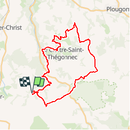
![](/images/other/stat-length.png)
![Excursión Bici de montaña Plounéour-Ménez - Espace VTT-FFC Morlaix Monts d'Arrée, circuit n°7 - Le Cloitre - Photo](https://media.geolcdn.com/t/1900/400/ext.pjpeg?maxdim=2&url=https%3A%2F%2Fservices.sitytrail.com%2FGeolivesWS%2FDownloadMedia.ashx%3FTrailID%3D101604%26Media%3D1793_2.jpg)
Espace VTT-FFC Morlaix Monts d'Arrée, circuit n°7 - Le Cloitre
tracegps
Usuario
![Longitud](/images/other/stat-length.png)
![Altitud máxima](https://static1.geolcdn.com/siteimages/upload/files/1508320355ic_sort_altitude_max_24dp.png)
![Desnivel positivo](https://static1.geolcdn.com/siteimages/upload/files/1508320355ic_sort_den_pos_24dp.png)
![Km-Effort](/images/other/stat-length.png)
![Altitud mínima](https://static1.geolcdn.com/siteimages/upload/files/1508320355ic_sort_altitude_min_24dp.png)
![Desnivel negativo](https://static1.geolcdn.com/siteimages/upload/files/1508320355ic_sort_den_neg_24dp.png)
![Boucle](https://static1.geolcdn.com/siteimages/upload/files/16400158638029165_repeat_loop_refresh_sync_direction_icon.png)
![Bici de montaña](https://static1.geolcdn.com/sitytour/trail-icons/202.png)
2h30
Dificultad : Muy difícil
![Escanee este código QR para abrir la excursión en la aplicación SityTrail](https://capi.geolives.com/qq0zvz2zws4bq2lad0pu/sitytour/trails/101604/qr.png?size=200)
Aplicación GPS de excursión GRATIS
A propósito
Ruta Bici de montaña de 32 km a descubrir en Bretaña, Finisterre, Plounéour-Ménez. Esta ruta ha sido propuesta por tracegps.
Descripción
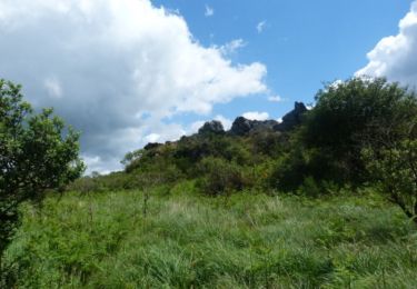
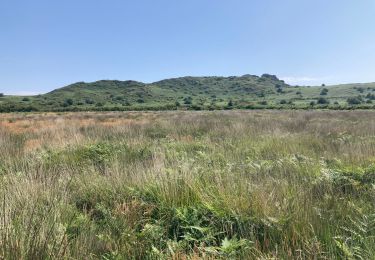
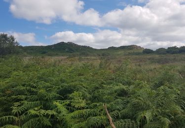
Espace VTT-FFC Morlaix Monts d’Arrée Circuit labellisé par la Fédération Française de Cyclisme. Au départ de l’Abbaye du Relec, ce circuit longe la ligne de crêtes des Monts d’Arrée où vivent les Korrigans : lutins bretons espiègles et farceurs. De nombreux points de vue vous font découvrir des paysages aussi diverses que grandioses.
Localización
Comentarios
Excursiones cerca
![Excursión A pie Plounéour-Ménez - Circuit de la Montagne - Photo](https://media.geolcdn.com/t/375/260/c3130118-aa43-405b-bf06-303e6c5f1e74.jpeg&format=jpg&maxdim=2)
![A pie A pie](https://static1.geolcdn.com/sitytour/trail-icons/100.png)
A pie
![](/images/other/stat-length.png)
![](https://static1.geolcdn.com/siteimages/upload/files/16400158638029165_repeat_loop_refresh_sync_direction_icon.png)
![Excursión Senderismo Plounéour-Ménez - PLONÉOUR MENEZ - Photo](https://media.geolcdn.com/t/375/260/18747b60-836a-4fea-8d5e-afb0bfbc2f19.jpg&format=jpg&maxdim=2)
![Senderismo Senderismo](https://static1.geolcdn.com/sitytour/trail-icons/101.png)
Senderismo
![](/images/other/stat-length.png)
![](https://static1.geolcdn.com/siteimages/upload/files/16400158638029165_repeat_loop_refresh_sync_direction_icon.png)
![Excursión Senderismo Plounéour-Ménez - Abbaye du Relec- Plounéour Ménez - Photo](https://media.geolcdn.com/t/375/260/ext.jpg?maxdim=2&url=https%3A%2F%2Fservices.sitytrail.com%2FGeolivesWS%2FDownloadMedia.ashx%3FTrailID%3D215232%26Media%3D15851_4.jpg)
![Senderismo Senderismo](https://static1.geolcdn.com/sitytour/trail-icons/101.png)
Senderismo
![](/images/other/stat-length.png)
![](https://static1.geolcdn.com/siteimages/upload/files/16400158638029165_repeat_loop_refresh_sync_direction_icon.png)
![Excursión Senderismo Plounéour-Ménez - Roch Trévézel - Photo](https://media.geolcdn.com/t/375/260/e0c8cd47-ed65-4046-81b3-2ba2abd5191b.jpg&format=jpg&maxdim=2)
![Senderismo Senderismo](https://static1.geolcdn.com/sitytour/trail-icons/101.png)
Senderismo
![](/images/other/stat-length.png)
![](https://static1.geolcdn.com/siteimages/upload/files/16400158638029165_repeat_loop_refresh_sync_direction_icon.png)
![Excursión Senderismo Berrien - BERRIEN - Photo](https://media.geolcdn.com/t/375/260/99e6cd0b-1e82-4917-b359-a604a63199d0.jpg&format=jpg&maxdim=2)
![Senderismo Senderismo](https://static1.geolcdn.com/sitytour/trail-icons/101.png)
![Excursión A pie Berrien - Circuit de l'abbaye du Relec - Photo](https://media.geolcdn.com/t/375/260/2092cde2-aa91-4a91-8f69-04318fbe31bd.jpeg&format=jpg&maxdim=2)
![A pie A pie](https://static1.geolcdn.com/sitytour/trail-icons/100.png)
A pie
![](/images/other/stat-length.png)
![](https://static1.geolcdn.com/siteimages/upload/files/16400158638029165_repeat_loop_refresh_sync_direction_icon.png)
![Excursión Senderismo Le Cloître-Saint-Thégonnec - Kermorgant - Photo](https://media.geolcdn.com/t/375/260/a9724d5e-2feb-4a5f-9b2e-41ef03b50db1.jpg&format=jpg&maxdim=2)
![Senderismo Senderismo](https://static1.geolcdn.com/sitytour/trail-icons/101.png)
Senderismo
![](/images/other/stat-length.png)
![](https://static1.geolcdn.com/siteimages/upload/files/16400158638029165_repeat_loop_refresh_sync_direction_icon.png)
![Excursión Senderismo Plounéour-Ménez - Balade de l'abbaye de Relecq - Photo](https://media.geolcdn.com/t/375/260/094260ee-59ef-4ea6-882a-8119688b51fa.jpg&format=jpg&maxdim=2)
![Senderismo Senderismo](https://static1.geolcdn.com/sitytour/trail-icons/101.png)
Senderismo
![](/images/other/stat-length.png)
![](https://static1.geolcdn.com/siteimages/upload/files/16400158638029165_repeat_loop_refresh_sync_direction_icon.png)
![Excursión Senderismo Plounéour-Ménez - Espace VTT-FFC Morlaix Monts d'Arrée, circuit n°7 - Le Cloitre - Photo](https://media.geolcdn.com/t/375/260/ext.jpg?maxdim=2&url=https%3A%2F%2Fservices.sitytrail.com%2FGeolivesWS%2FDownloadMedia.ashx%3FTrailID%3D101603%26Media%3D1793_2.jpg)
![Senderismo Senderismo](https://static1.geolcdn.com/sitytour/trail-icons/101.png)
Senderismo
![](/images/other/stat-length.png)
![](https://static1.geolcdn.com/siteimages/upload/files/16400158638029165_repeat_loop_refresh_sync_direction_icon.png)
Super parcours très varié à refaire première partie découverte des Landes seconde partie plus technique plus boisée plus Vtt .L ensemble faut un 4/5