![](/images/other/stat-length.png)
![Excursión Senderismo Valbelle - Sumiou - Lure - Saint-Pons - Photo](https://media.geolcdn.com/t/1900/400/ext.pjpeg?maxdim=2&url=https%3A%2F%2Fservices.sitytrail.com%2FGeolivesWS%2FDownloadMedia.ashx%3FTrailID%3D101507%26Media%3D1613_4.jpg)
Sumiou - Lure - Saint-Pons
tracegps
Usuario
![Longitud](/images/other/stat-length.png)
![Altitud máxima](https://static1.geolcdn.com/siteimages/upload/files/1508320355ic_sort_altitude_max_24dp.png)
![Desnivel positivo](https://static1.geolcdn.com/siteimages/upload/files/1508320355ic_sort_den_pos_24dp.png)
![Km-Effort](/images/other/stat-length.png)
![Altitud mínima](https://static1.geolcdn.com/siteimages/upload/files/1508320355ic_sort_altitude_min_24dp.png)
![Desnivel negativo](https://static1.geolcdn.com/siteimages/upload/files/1508320355ic_sort_den_neg_24dp.png)
![Boucle](https://static1.geolcdn.com/siteimages/upload/files/16400158638029165_repeat_loop_refresh_sync_direction_icon.png)
![Senderismo](https://static1.geolcdn.com/sitytour/trail-icons/101.png)
8h30
Dificultad : Muy difícil
![Escanee este código QR para abrir la excursión en la aplicación SityTrail](https://capi.geolives.com/qq0zvz2zws4bq2lad0pu/sitytour/trails/101507/qr.png?size=200)
Aplicación GPS de excursión GRATIS
A propósito
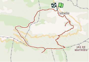
Ruta Senderismo de 24 km a descubrir en Provenza-Alpes-Costa Azul, Alpes de Alta Provenza, Valbelle. Esta ruta ha sido propuesta por tracegps.
Descripción
Longue randonnée (à faire en deux jours si possible). Départ des Richaud sur la D53. L'itinéraire suit en partie le GR6. Avant le Pas des Portes, sur le Sumiou, très beaux points de vue sur la vallée du Jabron. Montée sur la montagne de Lure, versant Nord, longue et rude, très raide sur la fin. Crête de la montagne de Lure souvent très ventée. Magnifiques points de vue sur toute la Haute-Provence, la vallée de la Durance, le pays de Forcalquier, le Sisteronnais. Bivouac possible depuis la crête: rester très discret, ne jamais allumer de feu. En redescendant depuis la Pas de Jean Richaud, on peut se ravitailler en eau à la source Saint-Pons. Excellente, pure et très bienvenue! Sur le chemin de retour, allez visiter la Chapelle Saint-Pons: un site extraordinaire, à ne pas manquer.
Localización
Comentarios
Excursiones cerca
![Excursión Senderismo Valbelle - VALBELLE . Chemin de Sara o l s - Photo](https://media.geolcdn.com/t/375/260/f5bc0f94-fea9-4cf8-899a-951c04f93f5f.jpg&format=jpg&maxdim=2)
![Senderismo Senderismo](https://static1.geolcdn.com/sitytour/trail-icons/101.png)
Senderismo
![](/images/other/stat-length.png)
![](https://static1.geolcdn.com/siteimages/upload/files/16400158638029165_repeat_loop_refresh_sync_direction_icon.png)
![Excursión Senderismo Valbelle - 05 chap st Pons col sumiou zel - Photo](https://media.geolcdn.com/t/375/260/654eadec-c68c-403c-8c9b-a622285d41ca.jpg&format=jpg&maxdim=2)
![Senderismo Senderismo](https://static1.geolcdn.com/sitytour/trail-icons/101.png)
Senderismo
![](/images/other/stat-length.png)
![](https://static1.geolcdn.com/siteimages/upload/files/16400158638029165_repeat_loop_refresh_sync_direction_icon.png)
![Excursión Senderismo Valbelle - chapelle saint Pont et montagne Sumiou - Photo](https://media.geolcdn.com/t/375/260/36d6cde7-c446-427e-9ab1-73d7e5890674.jpg&format=jpg&maxdim=2)
![Senderismo Senderismo](https://static1.geolcdn.com/sitytour/trail-icons/101.png)
Senderismo
![](/images/other/stat-length.png)
![](https://static1.geolcdn.com/siteimages/upload/files/16400158638029165_repeat_loop_refresh_sync_direction_icon.png)
![Excursión A pie Noyers-sur-Jabron - Montagne de Sumiou - Grotte des Peyrouets_19_01_2024 - Photo](https://media.geolcdn.com/t/375/260/d885e4ac-abdf-4f73-b427-5e5b97ac821b.jpg&format=jpg&maxdim=2)
![A pie A pie](https://static1.geolcdn.com/sitytour/trail-icons/100.png)
A pie
![](/images/other/stat-length.png)
![](https://static1.geolcdn.com/siteimages/upload/files/16400158638029165_repeat_loop_refresh_sync_direction_icon.png)
![Excursión Senderismo Valbelle - 04 chapelle St Pons 03.08.23 - Photo](https://media.geolcdn.com/t/375/260/a22dc00e-ca36-48e1-a26c-c25718a9238f.jpg&format=jpg&maxdim=2)
![Senderismo Senderismo](https://static1.geolcdn.com/sitytour/trail-icons/101.png)
Senderismo
![](/images/other/stat-length.png)
![](https://static1.geolcdn.com/siteimages/upload/files/16400158638029165_repeat_loop_refresh_sync_direction_icon.png)
![Excursión Senderismo Sisteron - BEVONS crêtes de Chapage o l s m - Photo](https://media.geolcdn.com/t/375/260/06496741-537d-4e32-9a57-13673b07b6c5.jpg&format=jpg&maxdim=2)
![Senderismo Senderismo](https://static1.geolcdn.com/sitytour/trail-icons/101.png)
Senderismo
![](/images/other/stat-length.png)
![](https://static1.geolcdn.com/siteimages/upload/files/16400158638029165_repeat_loop_refresh_sync_direction_icon.png)
![Excursión A pie Valbelle - Montagne de Lure - Photo](https://media.geolcdn.com/t/375/260/d2f7e93b-ac8d-4890-bbc4-c62d8ad565bf.jpg&format=jpg&maxdim=2)
![A pie A pie](https://static1.geolcdn.com/sitytour/trail-icons/100.png)
A pie
![](/images/other/stat-length.png)
![](https://static1.geolcdn.com/siteimages/upload/files/16400158638029165_repeat_loop_refresh_sync_direction_icon.png)
![Excursión Senderismo Valbelle - Tour de Sumiou - Photo](https://media.geolcdn.com/t/375/260/98046d43-9799-41dd-91ec-957f42022344.jpg&format=jpg&maxdim=2)
![Senderismo Senderismo](https://static1.geolcdn.com/sitytour/trail-icons/101.png)
Senderismo
![](/images/other/stat-length.png)
![](https://static1.geolcdn.com/siteimages/upload/files/16400158638029165_repeat_loop_refresh_sync_direction_icon.png)
![Excursión Senderismo Valbelle - Valbelle - Chapelle Saint Pons - Photo](https://media.geolcdn.com/t/375/260/ext.jpg?maxdim=2&url=https%3A%2F%2Fstatic1.geolcdn.com%2Fsiteimages%2Fupload%2Ffiles%2F1553511878bg_sport_marche.png)
![Senderismo Senderismo](https://static1.geolcdn.com/sitytour/trail-icons/101.png)
Senderismo
![](/images/other/stat-length.png)
![](https://static1.geolcdn.com/siteimages/upload/files/16400158638029165_repeat_loop_refresh_sync_direction_icon.png)