![](/images/other/stat-length.png)
![Excursión Senderismo Archail - Le sommet de Cucuyon et Pic de Couard. - Photo](https://media.geolcdn.com/t/1900/400/ext.pjpeg?maxdim=2&url=https%3A%2F%2Fservices.sitytrail.com%2FGeolivesWS%2FDownloadMedia.ashx%3FTrailID%3D101193%26Media%3D680_1.jpg)
Le sommet de Cucuyon et Pic de Couard.
tracegps
Usuario
![Longitud](/images/other/stat-length.png)
![Altitud máxima](https://static1.geolcdn.com/siteimages/upload/files/1508320355ic_sort_altitude_max_24dp.png)
![Desnivel positivo](https://static1.geolcdn.com/siteimages/upload/files/1508320355ic_sort_den_pos_24dp.png)
![Km-Effort](/images/other/stat-length.png)
![Altitud mínima](https://static1.geolcdn.com/siteimages/upload/files/1508320355ic_sort_altitude_min_24dp.png)
![Desnivel negativo](https://static1.geolcdn.com/siteimages/upload/files/1508320355ic_sort_den_neg_24dp.png)
![Boucle](https://static1.geolcdn.com/siteimages/upload/files/16400158638029165_repeat_loop_refresh_sync_direction_icon.png)
![Senderismo](https://static1.geolcdn.com/sitytour/trail-icons/101.png)
3h00
Dificultad : Difícil
![Escanee este código QR para abrir la excursión en la aplicación SityTrail](https://capi.geolives.com/qq0zvz2zws4bq2lad0pu/sitytour/trails/101193/qr.png?size=200)
Aplicación GPS de excursión GRATIS
A propósito
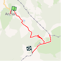
Ruta Senderismo de 7 km a descubrir en Provenza-Alpes-Costa Azul, Alpes de Alta Provenza, Archail. Esta ruta ha sido propuesta por tracegps.
Descripción
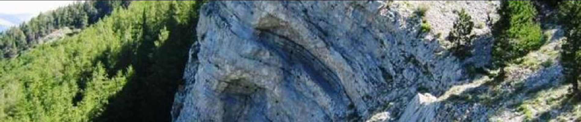
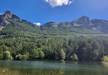
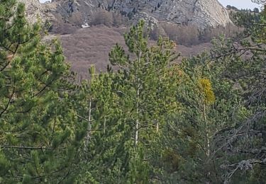
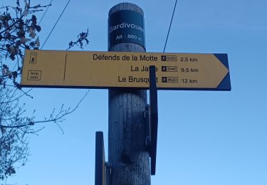
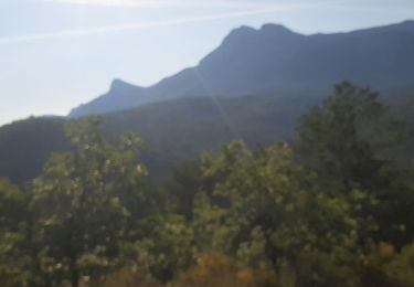
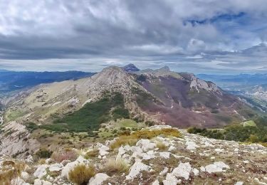
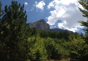
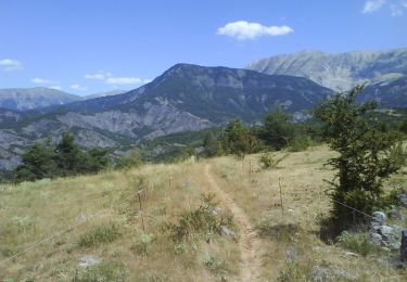
Une vallée un peu oubliée, deux sommets débonnaires, un bar improbable. L’aventure est aux portes de la ville ! On a tous eu un copain, au collège, qui portait un nom pas facile à porter. Hé bien, justement, ce petit coin aux abords de Digne accumule les patronymes peu sérieux. Entre le sommet de Cucuyon et le pic de Couard, dans cette vallée de Bouienc, mon cœur balance ! Et à l'usage, on se dit que l'on a les appellations que l'on mérite. Il suffit de se rendre au café du Couard, à Archail, pour comprendre qu'ici, on ne se prend pas au sérieux plus que cela ! Blagues mises à part, ce joli coin s'atteint par une sympathique route escarpée, tantôt dans les gorges, tantôt à travers les robines. Déjà un voyage en soi. L'arrivée au village, avec les alpages non loin, font rapidement oublier que Digne est tout proche ! Et c'est là toute la magie du coin : du dépaysement (l'arrivée au col est au delà de toutes les attentes), du dénivelé (quasi 1000 au compteur) et surtout de l'aventure, tant les paysages rencontrés sont variés... Ne cherchez pas, pour épater vos copains de passage ou pour faire germer l'idée que la vie par ici est vraiment belle, c'est un bon premier point de départ ! Toutes les infos et les photos sont sur Montagne-Cool
Localización
Comentarios
Excursiones cerca
![Excursión Senderismo Draix - DRAIX .REFUGE DE BELON .CRETE DE LA BLACHE .O L - Photo](https://media.geolcdn.com/t/375/260/ext.jpg?maxdim=2&url=https%3A%2F%2Fmedia.geolcdn.com%2Ff%2Fe8831a04-d962-4369-8704-d88e490a9a32.jpg)
![Senderismo Senderismo](https://static1.geolcdn.com/sitytour/trail-icons/101.png)
Senderismo
![](/images/other/stat-length.png)
![](https://static1.geolcdn.com/siteimages/upload/files/16400158638029165_repeat_loop_refresh_sync_direction_icon.png)
![Excursión Senderismo Marcoux - DIGNE . LES ROBINES DU BANASTRE n ol - Photo](https://media.geolcdn.com/t/375/260/ext.jpg?maxdim=2&url=https%3A%2F%2Fmedia.geolcdn.com%2Ff%2Fdcce991a-de45-4ec5-a0f2-a1115a3d83c1.jpg)
![Senderismo Senderismo](https://static1.geolcdn.com/sitytour/trail-icons/101.png)
Senderismo
![](/images/other/stat-length.png)
![](https://static1.geolcdn.com/siteimages/upload/files/16400158638029165_repeat_loop_refresh_sync_direction_icon.png)
![Excursión Senderismo Draix - 20210506_Draix - Tête de Chabane - Photo](https://media.geolcdn.com/t/375/260/ext.jpg?maxdim=2&url=https%3A%2F%2Fmedia.geolcdn.com%2Ff%2F0a858e9b-ff56-4fb8-8c1f-13fe4add2cbd.jpg)
![Senderismo Senderismo](https://static1.geolcdn.com/sitytour/trail-icons/101.png)
Senderismo
![](/images/other/stat-length.png)
![](https://static1.geolcdn.com/siteimages/upload/files/16400158638029165_repeat_loop_refresh_sync_direction_icon.png)
![Excursión Senderismo Archail - Archail cucuyon 10kms 850m - Photo](https://media.geolcdn.com/t/375/260/ext.jpg?maxdim=2&url=https%3A%2F%2Fmedia.geolcdn.com%2Ff%2Fc348f6c1-7258-47d7-9586-40bbf4181938.jpg)
![Senderismo Senderismo](https://static1.geolcdn.com/sitytour/trail-icons/101.png)
Senderismo
![](/images/other/stat-length.png)
![](https://static1.geolcdn.com/siteimages/upload/files/16400158638029165_repeat_loop_refresh_sync_direction_icon.png)
![Excursión Senderismo Le Brusquet - pierres ocres - Photo](https://media.geolcdn.com/t/375/260/ext.jpg?maxdim=2&url=https%3A%2F%2Fmedia.geolcdn.com%2Ff%2Fc4f58e11-452c-48be-8c08-199d0d0829dc.jpg)
![Senderismo Senderismo](https://static1.geolcdn.com/sitytour/trail-icons/101.png)
Senderismo
![](/images/other/stat-length.png)
![](https://static1.geolcdn.com/siteimages/upload/files/16400158638029165_repeat_loop_refresh_sync_direction_icon.png)
![Excursión Senderismo Le Brusquet - LE BRUSQUET .Le tour des Blaches n - Photo](https://media.geolcdn.com/t/375/260/ext.jpg?maxdim=2&url=https%3A%2F%2Fmedia.geolcdn.com%2Ff%2F8f49b41b-86fe-49d3-8404-7ee7a8e8e571.jpg)
![Senderismo Senderismo](https://static1.geolcdn.com/sitytour/trail-icons/101.png)
Senderismo
![](/images/other/stat-length.png)
![](https://static1.geolcdn.com/siteimages/upload/files/16400158638029165_repeat_loop_refresh_sync_direction_icon.png)
![Excursión Senderismo Archail - Randoguide - Photo](https://media.geolcdn.com/t/375/260/ext.jpg?maxdim=2&url=https%3A%2F%2Fservices.sitytrail.com%2FGeolivesWS%2FDownloadMedia.ashx%3FTrailID%3D142239%26Media%3D20120729151454.jpg)
![Senderismo Senderismo](https://static1.geolcdn.com/sitytour/trail-icons/101.png)
Senderismo
![](/images/other/stat-length.png)
![](https://static1.geolcdn.com/siteimages/upload/files/16400158638029165_repeat_loop_refresh_sync_direction_icon.png)
![Excursión Bici de montaña Archail - Grande Traversée des PréAlpes à VTT : La Bâtie Neuve (Maison forestière ruinée) - Col du Défens - Photo](https://media.geolcdn.com/t/375/260/ext.jpg?maxdim=2&url=https%3A%2F%2Fservices.sitytrail.com%2FGeolivesWS%2FDownloadMedia.ashx%3FTrailID%3D104770%26Media%3D8225_1.jpg)
![Bici de montaña Bici de montaña](https://static1.geolcdn.com/sitytour/trail-icons/202.png)
Bici de montaña
![](/images/other/stat-length.png)
![](https://static1.geolcdn.com/siteimages/upload/files/16400158638029165_repeat_loop_refresh_sync_direction_icon.png)
![Excursión sport Archail - Pic de couard - Photo](https://media.geolcdn.com/t/375/260/ext.jpg?maxdim=2&url=https%3A%2F%2Fsecurestorage.geolives.com%2Fsitytour%2Ftrail-bg%2Fdefault.jpg)
sport
![](/images/other/stat-length.png)
![](https://static1.geolcdn.com/siteimages/upload/files/16400158638029165_repeat_loop_refresh_sync_direction_icon.png)