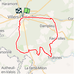
![](/images/other/stat-length.png)
![Excursión Bici de montaña Villers-Cotterêts - Villers-Cotterêts / Forêt de Retz 28 km - Photo](https://media.geolcdn.com/t/1900/400/ext.pjpeg?maxdim=2&url=https%3A%2F%2Fservices.sitytrail.com%2FGeolivesWS%2FDownloadMedia.ashx%3FTrailID%3D100985%26Media%3D484_1.jpg)
Villers-Cotterêts / Forêt de Retz 28 km
tracegps
Usuario
![Longitud](/images/other/stat-length.png)
![Altitud máxima](https://static1.geolcdn.com/siteimages/upload/files/1508320355ic_sort_altitude_max_24dp.png)
![Desnivel positivo](https://static1.geolcdn.com/siteimages/upload/files/1508320355ic_sort_den_pos_24dp.png)
![Km-Effort](/images/other/stat-length.png)
![Altitud mínima](https://static1.geolcdn.com/siteimages/upload/files/1508320355ic_sort_altitude_min_24dp.png)
![Desnivel negativo](https://static1.geolcdn.com/siteimages/upload/files/1508320355ic_sort_den_neg_24dp.png)
![Boucle](https://static1.geolcdn.com/siteimages/upload/files/16400158638029165_repeat_loop_refresh_sync_direction_icon.png)
![Bici de montaña](https://static1.geolcdn.com/sitytour/trail-icons/202.png)
2h00
Dificultad : Difícil
![Escanee este código QR para abrir la excursión en la aplicación SityTrail](https://capi.geolives.com/qq0zvz2zws4bq2lad0pu/sitytour/trails/100985/qr.png?size=200)
Aplicación GPS de excursión GRATIS
A propósito
Ruta Bici de montaña de 29 km a descubrir en Alta Francia, Aisne, Villers-Cotterêts. Esta ruta ha sido propuesta por tracegps.
Descripción
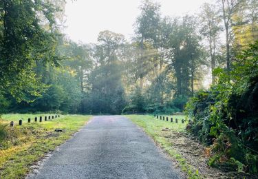
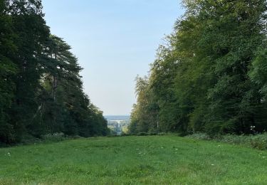
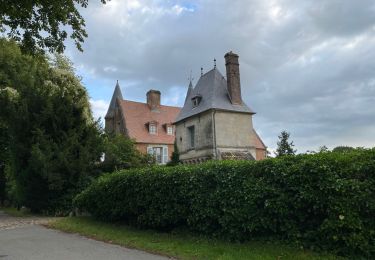
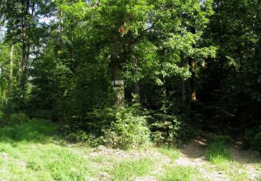
Avec plus de 13 000 hectares, la forêt de Retz est le plus grand massif forestier de l'Aisne et l'une des plus importantes forêts domaniales de France. C'est essentiellement une hêtraie, traitée en futaie régulière, mais on y trouve également le chêne, le charme, le frêne, le merisier, l'érable, le bouleau et le châtaignier ainsi que diverses essences de résineux sur les parties sablonneuses. Elle abrite une multiple faune sauvage : cerfs, biches, chevreuils, sangliers, faisans, lapins, lièvres et renards. C'est d'un observatoire élevé sur l'un des points culminants du massif que le général Mangin dirigea, le 18 juillet 1918, l'offensive qui devait mettre fin à la Grande Guerre. De nombreux circuits de randonnée pédestre permettent d'en découvrir les différents aspects, les trésors cachés parmi lesquels l'ermitage Saint-Hubert, la pierre Clouise, les étangs de Malva et de la Ramée, les fontaines, les roches et les points de vue dans un cadre de très belles futaies. Des itinéraires touristiques offrent une balade pittoresque à travers les villages typiques situés en lisière de la forêt de Retz. Documentation disponible à l'Office de Tourisme de Villers Cotterets, ICI
Localización
Comentarios
Excursiones cerca
![Excursión Senderismo Fleury - en Forêt de Retz_92_05_2022_Rond d'Orléans_Chapeau des Cordeliers_la Laie des étangs de Longpont - Photo](https://media.geolcdn.com/t/375/260/906f40d3-9cf9-4a7a-b2a8-7fc1acf87fb9.jpg&format=jpg&maxdim=2)
![Senderismo Senderismo](https://static1.geolcdn.com/sitytour/trail-icons/101.png)
Senderismo
![](/images/other/stat-length.png)
![](https://static1.geolcdn.com/siteimages/upload/files/16400158638029165_repeat_loop_refresh_sync_direction_icon.png)
![Excursión A pie Puiseux-en-Retz - Route du Faîte - Photo](https://media.geolcdn.com/t/375/260/ed0a74b8-9801-4168-82e4-02efd0513983.jpeg&format=jpg&maxdim=2)
![A pie A pie](https://static1.geolcdn.com/sitytour/trail-icons/100.png)
A pie
![](/images/other/stat-length.png)
![](https://static1.geolcdn.com/siteimages/upload/files/16400158638029165_repeat_loop_refresh_sync_direction_icon.png)
![Senderismo Senderismo](https://static1.geolcdn.com/sitytour/trail-icons/101.png)
Senderismo
![](/images/other/stat-length.png)
![](https://static1.geolcdn.com/siteimages/upload/files/16400158638029165_repeat_loop_refresh_sync_direction_icon.png)
![Senderismo Senderismo](https://static1.geolcdn.com/sitytour/trail-icons/101.png)
Senderismo
![](/images/other/stat-length.png)
![](https://static1.geolcdn.com/siteimages/upload/files/16400158638029165_repeat_loop_refresh_sync_direction_icon.png)
![Excursión Senderismo Villers-Cotterêts - Domaine de Coyolles - Photo](https://media.geolcdn.com/t/375/260/3c6e9d1b-7123-437c-8691-246218d3d596.jpg&format=jpg&maxdim=2)
![Senderismo Senderismo](https://static1.geolcdn.com/sitytour/trail-icons/101.png)
Senderismo
![](/images/other/stat-length.png)
![](https://static1.geolcdn.com/siteimages/upload/files/16400158638029165_repeat_loop_refresh_sync_direction_icon.png)
![Excursión Senderismo Vivières - en Forêt de Retz_88_autour du Regard Saint-Hubert et du Rond de la Reine - Photo](https://media.geolcdn.com/t/375/260/084779ef-6027-4c87-8964-afb49c5434d1.jpg&format=jpg&maxdim=2)
![Senderismo Senderismo](https://static1.geolcdn.com/sitytour/trail-icons/101.png)
Senderismo
![](/images/other/stat-length.png)
![](https://static1.geolcdn.com/siteimages/upload/files/16400158638029165_repeat_loop_refresh_sync_direction_icon.png)
![Excursión Senderismo Villers-Cotterêts - en forêt de Retz_87_la Laie des Masures par la Route Chrétiennette - Photo](https://media.geolcdn.com/t/375/260/9739a8e6-d34d-474c-95dd-6abe8fc69648.jpg&format=jpg&maxdim=2)
![Senderismo Senderismo](https://static1.geolcdn.com/sitytour/trail-icons/101.png)
Senderismo
![](/images/other/stat-length.png)
![](https://static1.geolcdn.com/siteimages/upload/files/16400158638029165_repeat_loop_refresh_sync_direction_icon.png)
![Excursión Senderismo Oigny-en-Valois - en forêt de Retz_86_les Laies de la Poudrerie et de la Fosse aux Demoiselles - Photo](https://media.geolcdn.com/t/375/260/5d558735-0a3b-4973-9268-9d4b9e0d42da.jpg&format=jpg&maxdim=2)
![Senderismo Senderismo](https://static1.geolcdn.com/sitytour/trail-icons/101.png)
Senderismo
![](/images/other/stat-length.png)
![](https://static1.geolcdn.com/siteimages/upload/files/16400158638029165_repeat_loop_refresh_sync_direction_icon.png)
![Senderismo Senderismo](https://static1.geolcdn.com/sitytour/trail-icons/101.png)
Senderismo
![](/images/other/stat-length.png)
![](https://static1.geolcdn.com/siteimages/upload/files/16400158638029165_repeat_loop_refresh_sync_direction_icon.png)