![](/images/other/stat-length.png)
![Excursión Senderismo Rochefort - GR des trappistes HAN-DAVERDISSE - Photo](https://media.geolcdn.com/t/1900/400/ext.pjpeg?maxdim=2&url=https%3A%2F%2Fservices.sitytrail.com%2FGeolivesWS%2FDownloadMedia.ashx%3FTrailID%3D1009519%26Media%3Dfix__20180723175735.jpg)
GR des trappistes HAN-DAVERDISSE
JEANMINNE
Usuario
![Longitud](/images/other/stat-length.png)
Longitud
25 km
![Altitud máxima](https://static1.geolcdn.com/siteimages/upload/files/1508320355ic_sort_altitude_max_24dp.png)
Altitud máxima
389 m
![Desnivel positivo](https://static1.geolcdn.com/siteimages/upload/files/1508320355ic_sort_den_pos_24dp.png)
Desnivel positivo
544 m
![Km-Effort](/images/other/stat-length.png)
Km-Effort
32 km
![Altitud mínima](https://static1.geolcdn.com/siteimages/upload/files/1508320355ic_sort_altitude_min_24dp.png)
Altitud mínima
150 m
![Desnivel negativo](https://static1.geolcdn.com/siteimages/upload/files/1508320355ic_sort_den_neg_24dp.png)
Desnivel negativo
469 m
![Boucle](https://static1.geolcdn.com/siteimages/upload/files/16400158638029165_repeat_loop_refresh_sync_direction_icon.png)
Boucle
No
Fecha de creación :
2019-01-15 13:29:30.201
Última modificación :
2019-01-15 13:29:30.201
![Senderismo](https://static1.geolcdn.com/sitytour/trail-icons/101.png)
6h02
Dificultad : Medio
![Escanee este código QR para abrir la excursión en la aplicación SityTrail](https://capi.geolives.com/qq0zvz2zws4bq2lad0pu/sitytour/trails/1009519/qr.png?size=200)
Aplicación GPS de excursión GRATIS
A propósito
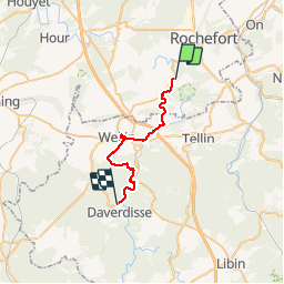
Ruta Senderismo de 25 km a descubrir en Valonia, Namur, Rochefort. Esta ruta ha sido propuesta por JEANMINNE.
Descripción
Variante via WELLIN (ravitaillement), Belvedere de la forêt de Wellin, passerelle Maria, Ravel et Moulin de DAVERDISSE
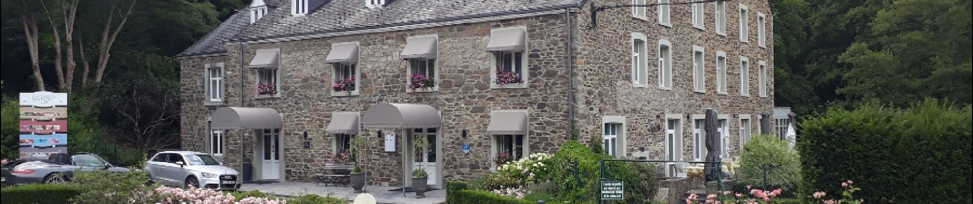
Localización
País:
Belgium
Región :
Valonia
Departamento/provincia :
Namur
Municipio :
Rochefort
Localidad:
Han-sur-Lesse
Salida:(Dec)
Salida:(UTM)
656347 ; 5555070 (31U) N.
Comentarios
Excursiones cerca
![Excursión Senderismo Rochefort - Walk along the river Lesse and through bucolic landscapes - Photo](https://media.geolcdn.com/t/375/260/ext.jpg?maxdim=2&url=https%3A%2F%2Fservices.sitytrail.com%2FGeolivesWS%2FDownloadMedia.ashx%3FTrailID%3D217391%26Media%3Df70ecdda-41e6-4428-8538-20d80ba8d70d.jpg)
![Senderismo Senderismo](https://static1.geolcdn.com/sitytour/trail-icons/101.png)
Walk along the river Lesse and through bucolic landscapes
Senderismo
Fácil
(7)
Rochefort,
Valonia,
Namur,
Belgium
![](/images/other/stat-length.png)
9,5 km | 11,3 km-effort
2h 28min
![](https://static1.geolcdn.com/siteimages/upload/files/16400158638029165_repeat_loop_refresh_sync_direction_icon.png)
Sí
![Excursión Senderismo Rochefort - Nature - The view from the Belvédère in Han-sur-Lesse - Photo](https://media.geolcdn.com/t/375/260/ext.jpg?maxdim=2&url=https%3A%2F%2Fservices.sitytrail.com%2FGeolivesWS%2FDownloadMedia.ashx%3FTrailID%3D193579%26Media%3D5797bc56-5327-4c2b-b581-d88d672bf775.jpg)
![Senderismo Senderismo](https://static1.geolcdn.com/sitytour/trail-icons/101.png)
Nature - The view from the Belvédère in Han-sur-Lesse
Senderismo
Difícil
(16)
Rochefort,
Valonia,
Namur,
Belgium
![](/images/other/stat-length.png)
4,8 km | 6,3 km-effort
1h 20min
![](https://static1.geolcdn.com/siteimages/upload/files/16400158638029165_repeat_loop_refresh_sync_direction_icon.png)
Sí
![Excursión Motor Rochefort - Car tour - Heritage : churches, chapels and abbeys - Rochefort - Photo](https://media.geolcdn.com/t/375/260/ext.jpg?maxdim=2&url=https%3A%2F%2Fservices.sitytrail.com%2FGeolivesWS%2FDownloadMedia.ashx%3FTrailID%3D153103%26Media%3D05603f1b-9f7c-481f-bc84-6cc819555dbb.jpg)
![Motor Motor](https://static1.geolcdn.com/sitytour/trail-icons/400.png)
Car tour - Heritage : churches, chapels and abbeys - Rochefort
Motor
Fácil
(5)
Rochefort,
Valonia,
Namur,
Belgium
![](/images/other/stat-length.png)
65 km | 78 km-effort
2h 40min
![](https://static1.geolcdn.com/siteimages/upload/files/16400158638029165_repeat_loop_refresh_sync_direction_icon.png)
Sí
![Excursión Senderismo Tellin - Tellin. Natura 2000, des sites qui valent le détour ! Lx 7 - Photo](https://media.geolcdn.com/t/375/260/ext.jpg?maxdim=2&url=https%3A%2F%2Fservices.sitytrail.com%2FGeolivesWS%2FDownloadMedia.ashx%3FTrailID%3D139723%26Media%3D4b6cd866-c01c-4092-b3ae-893d48db31d3.JPG)
![Senderismo Senderismo](https://static1.geolcdn.com/sitytour/trail-icons/101.png)
Tellin. Natura 2000, des sites qui valent le détour ! Lx 7
Senderismo
Medio
(7)
Tellin,
Valonia,
Luxemburgo,
Belgium
![](/images/other/stat-length.png)
9,6 km | 11,9 km-effort
1h 30min
![](https://static1.geolcdn.com/siteimages/upload/files/16400158638029165_repeat_loop_refresh_sync_direction_icon.png)
Sí
![Excursión Senderismo Rochefort - RB-Na-07 Raccourci - Ronde au pays des grottes - Photo](https://media.geolcdn.com/t/375/260/ext.jpg?maxdim=2&url=https%3A%2F%2Fservices.sitytrail.com%2FGeolivesWS%2FDownloadMedia.ashx%3FTrailID%3D213757%26Media%3D27dc9085-0323-4669-9df4-56be0512bfe6.jpg)
![Senderismo Senderismo](https://static1.geolcdn.com/sitytour/trail-icons/101.png)
RB-Na-07 Raccourci - Ronde au pays des grottes
Senderismo
Fácil
(9)
Rochefort,
Valonia,
Namur,
Belgium
![](/images/other/stat-length.png)
18,4 km | 24 km-effort
4h 59min
![](https://static1.geolcdn.com/siteimages/upload/files/16400158638029165_repeat_loop_refresh_sync_direction_icon.png)
Sí
![Excursión Senderismo Rochefort - Nature : Belvaux -Les Rouges-Gorges (the robins) - Photo](https://media.geolcdn.com/t/375/260/ext.jpg?maxdim=2&url=https%3A%2F%2Fservices.sitytrail.com%2FGeolivesWS%2FDownloadMedia.ashx%3FTrailID%3D262701%26Media%3D8d8e8ae8-731b-4f5d-ad26-e3a028302c41.jpg)
![Senderismo Senderismo](https://static1.geolcdn.com/sitytour/trail-icons/101.png)
Nature : Belvaux -Les Rouges-Gorges (the robins)
Senderismo
Fácil
(8)
Rochefort,
Valonia,
Namur,
Belgium
![](/images/other/stat-length.png)
6,5 km | 8,4 km-effort
1h 20min
![](https://static1.geolcdn.com/siteimages/upload/files/16400158638029165_repeat_loop_refresh_sync_direction_icon.png)
Sí
![Excursión Senderismo Rochefort - Nature : Belvaux -Les Rouges-Gorges (the robins) - Photo](https://media.geolcdn.com/t/375/260/ext.jpg?maxdim=2&url=https%3A%2F%2Fservices.sitytrail.com%2FGeolivesWS%2FDownloadMedia.ashx%3FTrailID%3D183910%26Media%3D410abbc6-7c13-4109-b7d7-92f0aeb383e2.jpg)
![Senderismo Senderismo](https://static1.geolcdn.com/sitytour/trail-icons/101.png)
Nature : Belvaux -Les Rouges-Gorges (the robins)
Senderismo
Fácil
(13)
Rochefort,
Valonia,
Namur,
Belgium
![](/images/other/stat-length.png)
5,8 km | 7,6 km-effort
1h 20min
![](https://static1.geolcdn.com/siteimages/upload/files/16400158638029165_repeat_loop_refresh_sync_direction_icon.png)
Sí
![Excursión Senderismo Rochefort - Nature - A discovery trail through Han-sur-Lesse - Photo](https://media.geolcdn.com/t/375/260/ext.jpg?maxdim=2&url=https%3A%2F%2Fservices.sitytrail.com%2FGeolivesWS%2FDownloadMedia.ashx%3FTrailID%3D148989%26Media%3D3c202c2f-ee01-4903-bd25-24913ec8637b.jpg)
![Senderismo Senderismo](https://static1.geolcdn.com/sitytour/trail-icons/101.png)
Nature - A discovery trail through Han-sur-Lesse
Senderismo
Muy fácil
(15)
Rochefort,
Valonia,
Namur,
Belgium
![](/images/other/stat-length.png)
4,8 km | 5,8 km-effort
1h 15min
![](https://static1.geolcdn.com/siteimages/upload/files/16400158638029165_repeat_loop_refresh_sync_direction_icon.png)
Sí
![Excursión Senderismo Tellin - Balade à Resteigne - Photo](https://media.geolcdn.com/t/375/260/ext.jpg?maxdim=2&url=https%3A%2F%2Fservices.sitytrail.com%2FGeolivesWS%2FDownloadMedia.ashx%3FTrailID%3D757564%26Media%3D2cc08ef1-2930-46d6-ab02-1279bd21e7ce.JPG)
![Senderismo Senderismo](https://static1.geolcdn.com/sitytour/trail-icons/101.png)
Balade à Resteigne
Senderismo
Fácil
(1)
Tellin,
Valonia,
Luxemburgo,
Belgium
![](/images/other/stat-length.png)
12,6 km | 16,2 km-effort
3h 32min
![](https://static1.geolcdn.com/siteimages/upload/files/16400158638029165_repeat_loop_refresh_sync_direction_icon.png)
Sí