![](/images/other/stat-length.png)
![Excursión Senderismo Les Belleville - Le refuge de Gittamelon - Photo](https://media.geolcdn.com/t/1900/400/ext.pjpeg?maxdim=2&url=https%3A%2F%2Fstatic1.geolcdn.com%2Fsiteimages%2Fupload%2Ffiles%2F1553511878bg_sport_marche.png)
Le refuge de Gittamelon
gilsep
Usuario
![Longitud](/images/other/stat-length.png)
Longitud
7,3 km
![Altitud máxima](https://static1.geolcdn.com/siteimages/upload/files/1508320355ic_sort_altitude_max_24dp.png)
Altitud máxima
1719 m
![Desnivel positivo](https://static1.geolcdn.com/siteimages/upload/files/1508320355ic_sort_den_pos_24dp.png)
Desnivel positivo
324 m
![Km-Effort](/images/other/stat-length.png)
Km-Effort
11,6 km
![Altitud mínima](https://static1.geolcdn.com/siteimages/upload/files/1508320355ic_sort_altitude_min_24dp.png)
Altitud mínima
1444 m
![Desnivel negativo](https://static1.geolcdn.com/siteimages/upload/files/1508320355ic_sort_den_neg_24dp.png)
Desnivel negativo
333 m
![Boucle](https://static1.geolcdn.com/siteimages/upload/files/16400158638029165_repeat_loop_refresh_sync_direction_icon.png)
Boucle
Sí
Fecha de creación :
2019-01-15 13:28:46.219
Última modificación :
2019-01-15 13:28:46.219
![Senderismo](https://static1.geolcdn.com/sitytour/trail-icons/101.png)
2h23
Dificultad : Medio
![Escanee este código QR para abrir la excursión en la aplicación SityTrail](https://capi.geolives.com/qq0zvz2zws4bq2lad0pu/sitytour/trails/1009349/qr.png?size=200)
Aplicación GPS de excursión GRATIS
A propósito
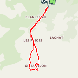
Ruta Senderismo de 7,3 km a descubrir en Auvergne-Rhône-Alpes, Saboya, Les Belleville. Esta ruta ha sido propuesta por gilsep.
Descripción
Laisser la voiture au parking de la Fenêtre (cote 1454). Variante pour le retour par la jolie route qui descend du refuge vers le parking.
Localización
País:
France
Región :
Auvergne-Rhône-Alpes
Departamento/provincia :
Saboya
Municipio :
Les Belleville
Localidad:
Saint-Martin-de-Belleville
Salida:(Dec)
Salida:(UTM)
302265 ; 5027565 (32T) N.
Comentarios
Excursiones cerca
![Excursión Senderismo Les Belleville - St Martin Belleville-gittamelon - Photo](https://media.geolcdn.com/t/375/260/ext.jpg?maxdim=2&url=https%3A%2F%2Fservices.sitytrail.com%2FGeolivesWS%2FDownloadMedia.ashx%3FTrailID%3D612997%26Media%3D33420aa9-f0ca-4bab-9183-c7bf9f0a6bf0.png)
![Senderismo Senderismo](https://static1.geolcdn.com/sitytour/trail-icons/101.png)
St Martin Belleville-gittamelon
Senderismo
Fácil
Les Belleville,
Auvergne-Rhône-Alpes,
Saboya,
France
![](/images/other/stat-length.png)
8,2 km | 13,3 km-effort
3h 30min
![](https://static1.geolcdn.com/siteimages/upload/files/16400158638029165_repeat_loop_refresh_sync_direction_icon.png)
Sí
![Excursión Senderismo Les Belleville - Montagne de Cherferie - Photo](https://media.geolcdn.com/t/375/260/805b7046-cec6-40c7-9989-cb4bd43bbcff.jpg&format=jpg&maxdim=2)
![Senderismo Senderismo](https://static1.geolcdn.com/sitytour/trail-icons/101.png)
Montagne de Cherferie
Senderismo
Medio
Les Belleville,
Auvergne-Rhône-Alpes,
Saboya,
France
![](/images/other/stat-length.png)
17,4 km | 28 km-effort
5h 42min
![](https://static1.geolcdn.com/siteimages/upload/files/16400158638029165_repeat_loop_refresh_sync_direction_icon.png)
Sí
![Excursión Senderismo Les Belleville - Beranger La croix de Jean Les refuges Le col de la lune - Photo](https://media.geolcdn.com/t/375/260/c5ad1e17-310b-48d4-b0e4-7e1619b4b8e6.jpg&format=jpg&maxdim=2)
![Senderismo Senderismo](https://static1.geolcdn.com/sitytour/trail-icons/101.png)
Beranger La croix de Jean Les refuges Le col de la lune
Senderismo
Difícil
Les Belleville,
Auvergne-Rhône-Alpes,
Saboya,
France
![](/images/other/stat-length.png)
14,5 km | 25 km-effort
4h 12min
![](https://static1.geolcdn.com/siteimages/upload/files/16400158638029165_repeat_loop_refresh_sync_direction_icon.png)
Sí
![Excursión Senderismo Les Belleville - col du cheval Noir +Lacs - Photo](https://media.geolcdn.com/t/375/260/ext.jpg?maxdim=2&url=https%3A%2F%2Fservices.sitytrail.com%2FGeolivesWS%2FDownloadMedia.ashx%3FTrailID%3D797893%26Media%3Dfix__20170728165727.jpg)
![Senderismo Senderismo](https://static1.geolcdn.com/sitytour/trail-icons/101.png)
col du cheval Noir +Lacs
Senderismo
Medio
Les Belleville,
Auvergne-Rhône-Alpes,
Saboya,
France
![](/images/other/stat-length.png)
13 km | 26 km-effort
7h 49min
![](https://static1.geolcdn.com/siteimages/upload/files/16400158638029165_repeat_loop_refresh_sync_direction_icon.png)
Sí
![Excursión Senderismo Les Belleville - pointe de la levriere - Photo](https://media.geolcdn.com/t/375/260/ext.jpg?maxdim=2&url=https%3A%2F%2Fstatic1.geolcdn.com%2Fsiteimages%2Fupload%2Ffiles%2F1553511878bg_sport_marche.png)
![Senderismo Senderismo](https://static1.geolcdn.com/sitytour/trail-icons/101.png)
pointe de la levriere
Senderismo
Fácil
(1)
Les Belleville,
Auvergne-Rhône-Alpes,
Saboya,
France
![](/images/other/stat-length.png)
5,6 km | 15,8 km-effort
2h 26min
![](https://static1.geolcdn.com/siteimages/upload/files/16400158638029165_repeat_loop_refresh_sync_direction_icon.png)
No
![Excursión Senderismo Les Belleville - Randoguide - Photo](https://media.geolcdn.com/t/375/260/ext.jpg?maxdim=2&url=https%3A%2F%2Fstatic1.geolcdn.com%2Fsiteimages%2Fupload%2Ffiles%2F1553511878bg_sport_marche.png)
![Senderismo Senderismo](https://static1.geolcdn.com/sitytour/trail-icons/101.png)
Randoguide
Senderismo
Medio
(1)
Les Belleville,
Auvergne-Rhône-Alpes,
Saboya,
France
![](/images/other/stat-length.png)
8,4 km | 13,3 km-effort
2h 52min
![](https://static1.geolcdn.com/siteimages/upload/files/16400158638029165_repeat_loop_refresh_sync_direction_icon.png)
Sí
![Excursión Senderismo Les Belleville - 07 sept 21 - Photo](https://media.geolcdn.com/t/375/260/88e1dd61-b92c-47f2-a26e-9d91b8f64722.jpg&format=jpg&maxdim=2)
![Senderismo Senderismo](https://static1.geolcdn.com/sitytour/trail-icons/101.png)
07 sept 21
Senderismo
Medio
Les Belleville,
Auvergne-Rhône-Alpes,
Saboya,
France
![](/images/other/stat-length.png)
10,5 km | 18,5 km-effort
3h 28min
![](https://static1.geolcdn.com/siteimages/upload/files/16400158638029165_repeat_loop_refresh_sync_direction_icon.png)
Sí
![Excursión Senderismo Les Belleville - Beranger - Photo](https://media.geolcdn.com/t/375/260/9bb038f2-4d5e-41ea-aad2-ded59c9c869b.jpg&format=jpg&maxdim=2)
![Senderismo Senderismo](https://static1.geolcdn.com/sitytour/trail-icons/101.png)
Beranger
Senderismo
Muy difícil
Les Belleville,
Auvergne-Rhône-Alpes,
Saboya,
France
![](/images/other/stat-length.png)
17,7 km | 32 km-effort
5h 8min
![](https://static1.geolcdn.com/siteimages/upload/files/16400158638029165_repeat_loop_refresh_sync_direction_icon.png)
Sí
![Excursión Raquetas de nieve Les Belleville - 73 - Vallée des Encombres - Photo](https://media.geolcdn.com/t/375/260/bc11d574-c020-4bd3-a478-aaac4e9aa0d8.jpg&format=jpg&maxdim=2)
![Raquetas de nieve Raquetas de nieve](https://static1.geolcdn.com/sitytour/trail-icons/504.png)
73 - Vallée des Encombres
Raquetas de nieve
Muy fácil
Les Belleville,
Auvergne-Rhône-Alpes,
Saboya,
France
![](/images/other/stat-length.png)
6,9 km | 10,9 km-effort
3h 0min
![](https://static1.geolcdn.com/siteimages/upload/files/16400158638029165_repeat_loop_refresh_sync_direction_icon.png)
Sí