![](/images/other/stat-length.png)
![Excursión Senderismo Gérardmer - Les Saut des Cuves - Photo](https://media.geolcdn.com/t/1900/400/ext.pjpeg?maxdim=2&url=https%3A%2F%2Fstatic1.geolcdn.com%2Fsiteimages%2Fupload%2Ffiles%2F1553511878bg_sport_marche.png)
Les Saut des Cuves
Baltykatt
Usuario
![Longitud](/images/other/stat-length.png)
Longitud
5,7 km
![Altitud máxima](https://static1.geolcdn.com/siteimages/upload/files/1508320355ic_sort_altitude_max_24dp.png)
Altitud máxima
925 m
![Desnivel positivo](https://static1.geolcdn.com/siteimages/upload/files/1508320355ic_sort_den_pos_24dp.png)
Desnivel positivo
264 m
![Km-Effort](/images/other/stat-length.png)
Km-Effort
9,2 km
![Altitud mínima](https://static1.geolcdn.com/siteimages/upload/files/1508320355ic_sort_altitude_min_24dp.png)
Altitud mínima
661 m
![Desnivel negativo](https://static1.geolcdn.com/siteimages/upload/files/1508320355ic_sort_den_neg_24dp.png)
Desnivel negativo
266 m
![Boucle](https://static1.geolcdn.com/siteimages/upload/files/16400158638029165_repeat_loop_refresh_sync_direction_icon.png)
Boucle
Sí
Fecha de creación :
2019-01-15 13:18:21.945
Última modificación :
2019-01-15 13:18:21.945
![Senderismo](https://static1.geolcdn.com/sitytour/trail-icons/101.png)
1h54
Dificultad : Fácil
![Escanee este código QR para abrir la excursión en la aplicación SityTrail](https://capi.geolives.com/qq0zvz2zws4bq2lad0pu/sitytour/trails/1007586/qr.png?size=200)
Aplicación GPS de excursión GRATIS
A propósito
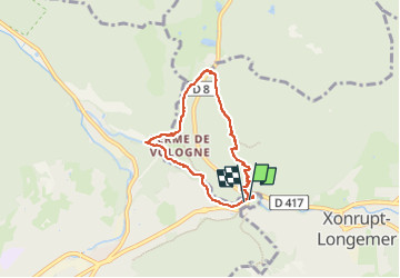
Ruta Senderismo de 5,7 km a descubrir en Gran Este, Vosgos, Gérardmer. Esta ruta ha sido propuesta por Baltykatt.
Descripción
Faite le 07/05/2015 avec notre fils de 10 ans. D'après : Mes balades préférées dans les Vosges de Daniel Wenger - N°17 Les Saut des Cuves, aux portes de Gérardmer. La durée indiquée pour le circuit est de 1h45.
Localización
País:
France
Región :
Gran Este
Departamento/provincia :
Vosgos
Municipio :
Gérardmer
Localidad:
Unknown
Salida:(Dec)
Salida:(UTM)
344358 ; 5327780 (32U) N.
Comentarios
Excursiones cerca
![Excursión Senderismo Gérardmer - gerardmer - la mauselaine . tête grauvelin . Roche boquet . croix claudé . hautes Vannes . la mauselaine - Photo](https://media.geolcdn.com/t/375/260/52e7d67b-2c25-481b-9a23-f7923e7ada1d.jpg&format=jpg&maxdim=2)
![Senderismo Senderismo](https://static1.geolcdn.com/sitytour/trail-icons/101.png)
gerardmer - la mauselaine . tête grauvelin . Roche boquet . croix claudé . ha...
Senderismo
Muy fácil
(1)
Gérardmer,
Gran Este,
Vosgos,
France
![](/images/other/stat-length.png)
11,3 km | 16,2 km-effort
3h 42min
![](https://static1.geolcdn.com/siteimages/upload/files/16400158638029165_repeat_loop_refresh_sync_direction_icon.png)
Sí
![Excursión Senderismo La Bresse - Lac de Lispach et sentier Dielaine - Photo](https://media.geolcdn.com/t/375/260/b54731ea-6209-4cff-b7c0-af5225a4f3ae.jpg&format=jpg&maxdim=2)
![Senderismo Senderismo](https://static1.geolcdn.com/sitytour/trail-icons/101.png)
Lac de Lispach et sentier Dielaine
Senderismo
Medio
(1)
La Bresse,
Gran Este,
Vosgos,
France
![](/images/other/stat-length.png)
9,7 km | 14,9 km-effort
2h 30min
![](https://static1.geolcdn.com/siteimages/upload/files/16400158638029165_repeat_loop_refresh_sync_direction_icon.png)
Sí
![Excursión Marcha nórdica Gérardmer - ramonchamp. observatoire de merelle, saut de la bourrique - Photo](https://media.geolcdn.com/t/375/260/b9b6a61e-3e1c-46cb-91c9-2c5e6825ee89.jpg&format=jpg&maxdim=2)
![Marcha nórdica Marcha nórdica](https://static1.geolcdn.com/sitytour/trail-icons/102.png)
ramonchamp. observatoire de merelle, saut de la bourrique
Marcha nórdica
Difícil
(1)
Gérardmer,
Gran Este,
Vosgos,
France
![](/images/other/stat-length.png)
11,1 km | 15,8 km-effort
3h 30min
![](https://static1.geolcdn.com/siteimages/upload/files/16400158638029165_repeat_loop_refresh_sync_direction_icon.png)
Sí
![Senderismo Senderismo](https://static1.geolcdn.com/sitytour/trail-icons/101.png)
Les 5 lacs autour du Hohneck
Senderismo
Muy difícil
(1)
La Bresse,
Gran Este,
Vosgos,
France
![](/images/other/stat-length.png)
21 km | 36 km-effort
7h 21min
![](https://static1.geolcdn.com/siteimages/upload/files/16400158638029165_repeat_loop_refresh_sync_direction_icon.png)
Sí
![Excursión Senderismo La Bresse - lac de Lispach - Photo](https://media.geolcdn.com/t/375/260/ext.jpg?maxdim=2&url=https%3A%2F%2Fservices.sitytrail.com%2FGeolivesWS%2FDownloadMedia.ashx%3FTrailID%3D441673%26Media%3D20150705125536.jpg)
![Senderismo Senderismo](https://static1.geolcdn.com/sitytour/trail-icons/101.png)
lac de Lispach
Senderismo
Fácil
(1)
La Bresse,
Gran Este,
Vosgos,
France
![](/images/other/stat-length.png)
10,4 km | 14,1 km-effort
4h 6min
![](https://static1.geolcdn.com/siteimages/upload/files/16400158638029165_repeat_loop_refresh_sync_direction_icon.png)
Sí
![Excursión Senderismo La Bresse - lac de Lispach - Photo](https://media.geolcdn.com/t/375/260/ext.jpg?maxdim=2&url=https%3A%2F%2Fservices.sitytrail.com%2FGeolivesWS%2FDownloadMedia.ashx%3FTrailID%3D441672%26Media%3D20150705124703.jpg)
![Senderismo Senderismo](https://static1.geolcdn.com/sitytour/trail-icons/101.png)
lac de Lispach
Senderismo
Fácil
(3)
La Bresse,
Gran Este,
Vosgos,
France
![](/images/other/stat-length.png)
10,4 km | 14,1 km-effort
4h 6min
![](https://static1.geolcdn.com/siteimages/upload/files/16400158638029165_repeat_loop_refresh_sync_direction_icon.png)
Sí
![Excursión Senderismo Ban-sur-Meurthe-Clefcy - La vallée de Belbriette - Ban-sur-Meurthe-Clefcy - Photo](https://media.geolcdn.com/t/375/260/ext.jpg?maxdim=2&url=https%3A%2F%2Fservices.sitytrail.com%2FGeolivesWS%2FDownloadMedia.ashx%3FTrailID%3D172951%26Media%3D14431_5.jpg)
![Senderismo Senderismo](https://static1.geolcdn.com/sitytour/trail-icons/101.png)
La vallée de Belbriette - Ban-sur-Meurthe-Clefcy
Senderismo
Medio
(2)
Ban-sur-Meurthe-Clefcy,
Gran Este,
Vosgos,
France
![](/images/other/stat-length.png)
9,8 km | 12,6 km-effort
2h 30min
![](https://static1.geolcdn.com/siteimages/upload/files/16400158638029165_repeat_loop_refresh_sync_direction_icon.png)
Sí
![Excursión Senderismo Gérardmer - La Tête de Mérelle - Photo](https://media.geolcdn.com/t/375/260/ext.jpg?maxdim=2&url=https%3A%2F%2Fservices.sitytrail.com%2FGeolivesWS%2FDownloadMedia.ashx%3FTrailID%3D110294%26Media%3D5711_6.jpg)
![Senderismo Senderismo](https://static1.geolcdn.com/sitytour/trail-icons/101.png)
La Tête de Mérelle
Senderismo
Medio
(5)
Gérardmer,
Gran Este,
Vosgos,
France
![](/images/other/stat-length.png)
4,7 km | 9 km-effort
2h 30min
![](https://static1.geolcdn.com/siteimages/upload/files/16400158638029165_repeat_loop_refresh_sync_direction_icon.png)
Sí
![Excursión Senderismo Gérardmer - 2018 05 24 obs Merelle - Photo](https://media.geolcdn.com/t/375/260/ext.jpg?maxdim=2&url=https%3A%2F%2Fservices.sitytrail.com%2FGeolivesWS%2FDownloadMedia.ashx%3FTrailID%3D973101%26Media%3Dfix__20180524120350.jpg)
![Senderismo Senderismo](https://static1.geolcdn.com/sitytour/trail-icons/101.png)
2018 05 24 obs Merelle
Senderismo
Medio
(3)
Gérardmer,
Gran Este,
Vosgos,
France
![](/images/other/stat-length.png)
11,5 km | 16,3 km-effort
4h 40min
![](https://static1.geolcdn.com/siteimages/upload/files/16400158638029165_repeat_loop_refresh_sync_direction_icon.png)
Sí