![](/images/other/stat-length.png)
![Excursión Senderismo Μάρπησσα - Piso Livadi Dryos sentier côtier - Photo](https://media.geolcdn.com/t/1900/400/ext.pjpeg?maxdim=2&url=https%3A%2F%2Fservices.sitytrail.com%2FGeolivesWS%2FDownloadMedia.ashx%3FTrailID%3D1005451%26Media%3D20180710125012.jpg)
Piso Livadi Dryos sentier côtier
pjjrevrard
Usuario
![Longitud](/images/other/stat-length.png)
Longitud
8,6 km
![Altitud máxima](https://static1.geolcdn.com/siteimages/upload/files/1508320355ic_sort_altitude_max_24dp.png)
Altitud máxima
53 m
![Desnivel positivo](https://static1.geolcdn.com/siteimages/upload/files/1508320355ic_sort_den_pos_24dp.png)
Desnivel positivo
62 m
![Km-Effort](/images/other/stat-length.png)
Km-Effort
9,5 km
![Altitud mínima](https://static1.geolcdn.com/siteimages/upload/files/1508320355ic_sort_altitude_min_24dp.png)
Altitud mínima
0 m
![Desnivel negativo](https://static1.geolcdn.com/siteimages/upload/files/1508320355ic_sort_den_neg_24dp.png)
Desnivel negativo
91 m
![Boucle](https://static1.geolcdn.com/siteimages/upload/files/16400158638029165_repeat_loop_refresh_sync_direction_icon.png)
Boucle
No
Fecha de creación :
2019-01-15 13:08:19.385
Última modificación :
2019-01-15 13:08:19.385
![Senderismo](https://static1.geolcdn.com/sitytour/trail-icons/101.png)
2h05
Dificultad : Fácil
![Escanee este código QR para abrir la excursión en la aplicación SityTrail](https://capi.geolives.com/qq0zvz2zws4bq2lad0pu/sitytour/trails/1005451/qr.png?size=200)
Aplicación GPS de excursión GRATIS
A propósito
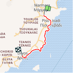
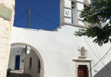
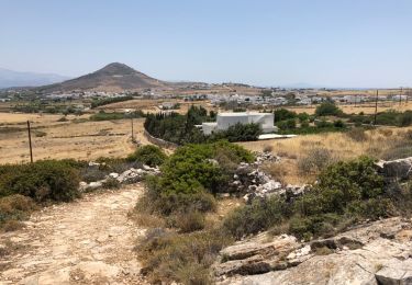
Ruta Senderismo de 8,6 km a descubrir en Αποκεντρωμένη Διοίκηση Αιγαίου, Περιφερειακή Ενότητα Πάρου. Esta ruta ha sido propuesta por pjjrevrard.
Descripción
Belle promenade côtière qui permet de découvrir quelques unes des belles et populaires plages de Paros. Reprendre le bus à Dryos pour regagner Marpissa (horaires sur http://ktelparou.gr/en/bus-schedules.html )
Localización
País:
Greece
Región :
Αποκεντρωμένη Διοίκηση Αιγαίου
Departamento/provincia :
Περιφερειακή Ενότητα Πάρου
Municipio :
Μάρπησσα
Localidad:
Unknown
Salida:(Dec)
Salida:(UTM)
344334 ; 4101171 (35S) N.
Comentarios
Excursiones cerca
![Excursión Senderismo - Prodromos - Lefkes A-R par la « Route Byzantine « - Photo](https://media.geolcdn.com/t/375/260/5d6008ae-af9f-4f61-8501-277c9966697e.jpg&format=jpg&maxdim=2)
![Senderismo Senderismo](https://static1.geolcdn.com/sitytour/trail-icons/101.png)
Prodromos - Lefkes A-R par la « Route Byzantine «
Senderismo
Medio
,
Αποκεντρωμένη Διοίκηση Αιγαίου,
Περιφερειακή Ενότητα Πάρου,
Greece
![](/images/other/stat-length.png)
7,8 km | 11,5 km-effort
2h 24min
![](https://static1.geolcdn.com/siteimages/upload/files/16400158638029165_repeat_loop_refresh_sync_direction_icon.png)
No
![Excursión Senderismo - Lefkes Aspro Chorio par la kavouropotamos - Photo](https://media.geolcdn.com/t/375/260/ext.jpg?maxdim=2&url=https%3A%2F%2Fservices.sitytrail.com%2FGeolivesWS%2FDownloadMedia.ashx%3FTrailID%3D1005450%26Media%3D20180708122353.jpg)
![Senderismo Senderismo](https://static1.geolcdn.com/sitytour/trail-icons/101.png)
Lefkes Aspro Chorio par la kavouropotamos
Senderismo
Fácil
,
Αποκεντρωμένη Διοίκηση Αιγαίου,
Περιφερειακή Ενότητα Πάρου,
Greece
![](/images/other/stat-length.png)
9,2 km | 14,1 km-effort
3h 29min
![](https://static1.geolcdn.com/siteimages/upload/files/16400158638029165_repeat_loop_refresh_sync_direction_icon.png)
No
![Excursión Senderismo - Marpissa Marmara Lefkes - Photo](https://media.geolcdn.com/t/375/260/05bcdd77-9505-43a2-8cd4-015e357a9478.jpg&format=jpg&maxdim=2)
![Senderismo Senderismo](https://static1.geolcdn.com/sitytour/trail-icons/101.png)
Marpissa Marmara Lefkes
Senderismo
,
Αποκεντρωμένη Διοίκηση Αιγαίου,
Περιφερειακή Ενότητα Πάρου,
Greece
![](/images/other/stat-length.png)
7,8 km | 11,1 km-effort
3h 26min
![](https://static1.geolcdn.com/siteimages/upload/files/16400158638029165_repeat_loop_refresh_sync_direction_icon.png)
No
![Excursión Senderismo - prodromos lefkes retour byzantin - Photo](https://media.geolcdn.com/t/375/260/ext.jpg?maxdim=2&url=https%3A%2F%2Fservices.sitytrail.com%2FGeolivesWS%2FDownloadMedia.ashx%3FTrailID%3D1005456%26Media%3D20180706125948.jpg)
![Senderismo Senderismo](https://static1.geolcdn.com/sitytour/trail-icons/101.png)
prodromos lefkes retour byzantin
Senderismo
Medio
,
Αποκεντρωμένη Διοίκηση Αιγαίου,
Περιφερειακή Ενότητα Πάρου,
Greece
![](/images/other/stat-length.png)
11,7 km | 16,6 km-effort
3h 29min
![](https://static1.geolcdn.com/siteimages/upload/files/16400158638029165_repeat_loop_refresh_sync_direction_icon.png)
Sí
![Excursión Senderismo - Prodomos - Lefkès (chemin Byzantin) - Photo](https://media.geolcdn.com/t/375/260/ext.jpg?maxdim=2&url=https%3A%2F%2Fstatic1.geolcdn.com%2Fsiteimages%2Fupload%2Ffiles%2F1553511878bg_sport_marche.png)
![Senderismo Senderismo](https://static1.geolcdn.com/sitytour/trail-icons/101.png)
Prodomos - Lefkès (chemin Byzantin)
Senderismo
Fácil
,
Αποκεντρωμένη Διοίκηση Αιγαίου,
Περιφερειακή Ενότητα Πάρου,
Greece
![](/images/other/stat-length.png)
6,4 km | 9,4 km-effort
1h 16min
![](https://static1.geolcdn.com/siteimages/upload/files/16400158638029165_repeat_loop_refresh_sync_direction_icon.png)
No