![](/images/other/stat-length.png)
![Excursión Senderismo La Plagne-Tarentaise - La Sciaz par le sentier des vignes - Photo](https://media.geolcdn.com/t/1900/400/ext.pjpeg?maxdim=2&url=https%3A%2F%2Fstatic1.geolcdn.com%2Fsiteimages%2Fupload%2Ffiles%2F1553511878bg_sport_marche.png)
La Sciaz par le sentier des vignes
gilsep
Usuario
![Longitud](/images/other/stat-length.png)
Longitud
6,2 km
![Altitud máxima](https://static1.geolcdn.com/siteimages/upload/files/1508320355ic_sort_altitude_max_24dp.png)
Altitud máxima
972 m
![Desnivel positivo](https://static1.geolcdn.com/siteimages/upload/files/1508320355ic_sort_den_pos_24dp.png)
Desnivel positivo
193 m
![Km-Effort](/images/other/stat-length.png)
Km-Effort
8,8 km
![Altitud mínima](https://static1.geolcdn.com/siteimages/upload/files/1508320355ic_sort_altitude_min_24dp.png)
Altitud mínima
783 m
![Desnivel negativo](https://static1.geolcdn.com/siteimages/upload/files/1508320355ic_sort_den_neg_24dp.png)
Desnivel negativo
194 m
![Boucle](https://static1.geolcdn.com/siteimages/upload/files/16400158638029165_repeat_loop_refresh_sync_direction_icon.png)
Boucle
Sí
Fecha de creación :
2019-01-15 13:06:47.063
Última modificación :
2019-01-15 13:06:47.063
![Senderismo](https://static1.geolcdn.com/sitytour/trail-icons/101.png)
1h42
Dificultad : Fácil
![Escanee este código QR para abrir la excursión en la aplicación SityTrail](https://capi.geolives.com/qq0zvz2zws4bq2lad0pu/sitytour/trails/1005103/qr.png?size=200)
Aplicación GPS de excursión GRATIS
A propósito
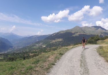
Ruta Senderismo de 6,2 km a descubrir en Auvergne-Rhône-Alpes, Saboya, La Plagne-Tarentaise. Esta ruta ha sido propuesta por gilsep.
Descripción
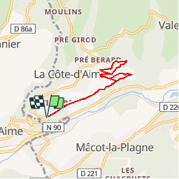
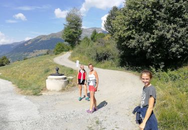
Une promenade facile balisée en jaune à travers les vignes au-dessus d'Aime et jusqu'à La Sciaz.
Il faut prendre la route de la Côte d'Aime et s'engager dans le petit chemin droite.
Localización
País:
France
Región :
Auvergne-Rhône-Alpes
Departamento/provincia :
Saboya
Municipio :
La Plagne-Tarentaise
Localidad:
La Côte-d'Aime
Salida:(Dec)
Salida:(UTM)
317475 ; 5047765 (32T) N.
Comentarios
Excursiones cerca
![Excursión Senderismo La Plagne-Tarentaise - Les Fours- belle rando facile - Photo](https://media.geolcdn.com/t/375/260/ce194bd9-f6a3-46bc-be1d-c29d53223d34.jpg&format=jpg&maxdim=2)
![Senderismo Senderismo](https://static1.geolcdn.com/sitytour/trail-icons/101.png)
Les Fours- belle rando facile
Senderismo
Fácil
(1)
La Plagne-Tarentaise,
Auvergne-Rhône-Alpes,
Saboya,
France
![](/images/other/stat-length.png)
8,6 km | 12 km-effort
2h 55min
![](https://static1.geolcdn.com/siteimages/upload/files/16400158638029165_repeat_loop_refresh_sync_direction_icon.png)
Sí
![Excursión Senderismo La Plagne-Tarentaise - Les Fours - Photo](https://media.geolcdn.com/t/375/260/ext.jpg?maxdim=2&url=https%3A%2F%2Fservices.sitytrail.com%2FGeolivesWS%2FDownloadMedia.ashx%3FTrailID%3D962720%26Media%3Dfix__20180506164939.jpg)
![Senderismo Senderismo](https://static1.geolcdn.com/sitytour/trail-icons/101.png)
Les Fours
Senderismo
Fácil
(2)
La Plagne-Tarentaise,
Auvergne-Rhône-Alpes,
Saboya,
France
![](/images/other/stat-length.png)
8,4 km | 11,7 km-effort
2h 50min
![](https://static1.geolcdn.com/siteimages/upload/files/16400158638029165_repeat_loop_refresh_sync_direction_icon.png)
Sí
![Excursión A pie La Plagne-Tarentaise - Les Frasses - Photo](https://media.geolcdn.com/t/375/260/57e5726a-4c56-4000-a6b5-c37a4dc312d4.jpeg&format=jpg&maxdim=2)
![A pie A pie](https://static1.geolcdn.com/sitytour/trail-icons/100.png)
Les Frasses
A pie
Fácil
La Plagne-Tarentaise,
Auvergne-Rhône-Alpes,
Saboya,
France
![](/images/other/stat-length.png)
5,7 km | 7,8 km-effort
1h 45min
![](https://static1.geolcdn.com/siteimages/upload/files/16400158638029165_repeat_loop_refresh_sync_direction_icon.png)
No
![Excursión Esquí de fondo La Plagne-Tarentaise - La Chaille. col à l'ouest du Rocher st Laurent - Photo](https://media.geolcdn.com/t/375/260/a890abcf-139f-4fa9-a31e-dd584261d663.jpg&format=jpg&maxdim=2)
![Esquí de fondo Esquí de fondo](https://static1.geolcdn.com/sitytour/trail-icons/503.png)
La Chaille. col à l'ouest du Rocher st Laurent
Esquí de fondo
Fácil
La Plagne-Tarentaise,
Auvergne-Rhône-Alpes,
Saboya,
France
![](/images/other/stat-length.png)
13,9 km | 29 km-effort
6h 38min
![](https://static1.geolcdn.com/siteimages/upload/files/16400158638029165_repeat_loop_refresh_sync_direction_icon.png)
Sí
![Excursión Esquí de fondo Aime-la-Plagne - le Crêt du Rey face Est - Photo](https://media.geolcdn.com/t/375/260/85030d7c-824d-4fcc-8e4c-058138221f73.jpg&format=jpg&maxdim=2)
![Esquí de fondo Esquí de fondo](https://static1.geolcdn.com/sitytour/trail-icons/503.png)
le Crêt du Rey face Est
Esquí de fondo
Difícil
Aime-la-Plagne,
Auvergne-Rhône-Alpes,
Saboya,
France
![](/images/other/stat-length.png)
18,7 km | 36 km-effort
8h 21min
![](https://static1.geolcdn.com/siteimages/upload/files/16400158638029165_repeat_loop_refresh_sync_direction_icon.png)
Sí
![Excursión Senderismo Aime-la-Plagne - Balcons de Granier - Photo](https://media.geolcdn.com/t/375/260/ext.jpg?maxdim=2&url=https%3A%2F%2Fstatic1.geolcdn.com%2Fsiteimages%2Fupload%2Ffiles%2F1553511878bg_sport_marche.png)
![Senderismo Senderismo](https://static1.geolcdn.com/sitytour/trail-icons/101.png)
Balcons de Granier
Senderismo
Fácil
(2)
Aime-la-Plagne,
Auvergne-Rhône-Alpes,
Saboya,
France
![](/images/other/stat-length.png)
7,3 km | 12,6 km-effort
2h 48min
![](https://static1.geolcdn.com/siteimages/upload/files/16400158638029165_repeat_loop_refresh_sync_direction_icon.png)
Sí
![Excursión Raquetas de nieve Aime-la-Plagne - combe benite - Photo](https://media.geolcdn.com/t/375/260/ext.jpg?maxdim=2&url=https%3A%2F%2Fstatic1.geolcdn.com%2Fsiteimages%2Fupload%2Ffiles%2F1524743153raquette.jpg)
![Raquetas de nieve Raquetas de nieve](https://static1.geolcdn.com/sitytour/trail-icons/504.png)
combe benite
Raquetas de nieve
Difícil
(1)
Aime-la-Plagne,
Auvergne-Rhône-Alpes,
Saboya,
France
![](/images/other/stat-length.png)
5,3 km | 16,4 km-effort
2h 56min
![](https://static1.geolcdn.com/siteimages/upload/files/16400158638029165_repeat_loop_refresh_sync_direction_icon.png)
No
![Excursión Senderismo Aime-la-Plagne - Mont Coin - Photo](https://media.geolcdn.com/t/375/260/4f563390-2587-42f5-8996-ce783b07d0a6.jpg&format=jpg&maxdim=2)
![Senderismo Senderismo](https://static1.geolcdn.com/sitytour/trail-icons/101.png)
Mont Coin
Senderismo
Medio
Aime-la-Plagne,
Auvergne-Rhône-Alpes,
Saboya,
France
![](/images/other/stat-length.png)
17 km | 32 km-effort
6h 59min
![](https://static1.geolcdn.com/siteimages/upload/files/16400158638029165_repeat_loop_refresh_sync_direction_icon.png)
Sí
![Excursión Senderismo La Plagne-Tarentaise - Les Fours - Photo](https://media.geolcdn.com/t/375/260/39545460-f6e7-4e63-9fb8-93f38f181000.jpg&format=jpg&maxdim=2)
![Senderismo Senderismo](https://static1.geolcdn.com/sitytour/trail-icons/101.png)
Les Fours
Senderismo
Fácil
La Plagne-Tarentaise,
Auvergne-Rhône-Alpes,
Saboya,
France
![](/images/other/stat-length.png)
8,4 km | 11,8 km-effort
2h 25min
![](https://static1.geolcdn.com/siteimages/upload/files/16400158638029165_repeat_loop_refresh_sync_direction_icon.png)
Sí