![](/images/other/stat-length.png)
- Excursiones
- Outdoor
- Italy
- Piamonte
- Turín
- San Giorgio Canavese
San Giorgio Canavese, Turín: Los mejores itinerarios de excursión, recorridos, paseos y sendas
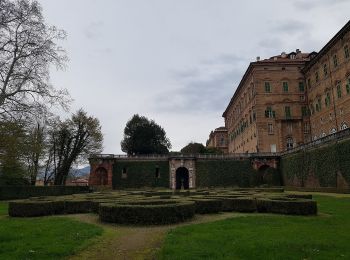
San Giorgio Canavese: Descubra las mejores excursiones: 4 a pie. Todos estos circuitos, recorridos, itinerarios y actividades al aire libre están disponibles en nuestras aplicaciones SityTrail para smartphone y tablet.
Los mejores recorridos (4)
![Excursión A pie San Giorgio Canavese - ETOP1320000 - Photo](https://media.geolcdn.com/t/350/260/fb035e0f-1086-4f18-ba97-e1d3bed2eb0f.jpeg&format=jpg&maxdim=2)
![A pie A pie](https://static1.geolcdn.com/sitytour/trail-icons/100.png)
Km
A pie
![](/images/other/stat-length.png)
![](https://static1.geolcdn.com/siteimages/upload/files/1508320355ic_sort_den_pos_24dp.png)
![](https://static1.geolcdn.com/siteimages/upload/files/1508320355ic_sort_den_neg_24dp.png)
![](https://static1.geolcdn.com/siteimages/upload/files/16400158638029165_repeat_loop_refresh_sync_direction_icon.png)
• Symbol: unmarked Sitio web: http://www.caiivrea.it/
![Excursión A pie San Giorgio Canavese - ETOP13300A - Photo](https://media.geolcdn.com/t/350/260/71605cd3-1216-4ce3-b88c-6af1149dcd7b.jpeg&format=jpg&maxdim=2)
![A pie A pie](https://static1.geolcdn.com/sitytour/trail-icons/100.png)
Km
A pie
![](/images/other/stat-length.png)
![](https://static1.geolcdn.com/siteimages/upload/files/1508320355ic_sort_den_pos_24dp.png)
![](https://static1.geolcdn.com/siteimages/upload/files/1508320355ic_sort_den_neg_24dp.png)
![](https://static1.geolcdn.com/siteimages/upload/files/16400158638029165_repeat_loop_refresh_sync_direction_icon.png)
• Symbol: unmarked Sitio web: http://www.caiivrea.it/
![Excursión A pie San Giorgio Canavese - ETOP135000A - Photo](https://media.geolcdn.com/t/350/260/ext.jpg?maxdim=2&url=https%3A%2F%2Fstatic1.geolcdn.com%2Fsiteimages%2Fupload%2Ffiles%2F1545311037marcheuse_200dpi.jpg)
![A pie A pie](https://static1.geolcdn.com/sitytour/trail-icons/100.png)
Km
A pie
![](/images/other/stat-length.png)
![](https://static1.geolcdn.com/siteimages/upload/files/1508320355ic_sort_den_pos_24dp.png)
![](https://static1.geolcdn.com/siteimages/upload/files/1508320355ic_sort_den_neg_24dp.png)
![](https://static1.geolcdn.com/siteimages/upload/files/16400158638029165_repeat_loop_refresh_sync_direction_icon.png)
• Symbol: unmarked Sitio web: http://www.caiivrea.it/
![Excursión A pie San Giorgio Canavese - Alta Via dell’Anfiteatro Morenico di Ivrea - Itinerario di Collegamento di San Giorgio - Photo](https://media.geolcdn.com/t/350/260/ext.jpg?maxdim=2&url=https%3A%2F%2Fstatic1.geolcdn.com%2Fsiteimages%2Fupload%2Ffiles%2F1545311037marcheuse_200dpi.jpg)
![A pie A pie](https://static1.geolcdn.com/sitytour/trail-icons/100.png)
Km
A pie
![](/images/other/stat-length.png)
![](https://static1.geolcdn.com/siteimages/upload/files/1508320355ic_sort_den_pos_24dp.png)
![](https://static1.geolcdn.com/siteimages/upload/files/1508320355ic_sort_den_neg_24dp.png)
![](https://static1.geolcdn.com/siteimages/upload/files/16400158638029165_repeat_loop_refresh_sync_direction_icon.png)
• Trail created by Ecomuseo dell’Anfiteatro Morenico di Ivrea ( AMI ). Symbol: two white triangles vertically opposed ...
4 excursiones mostradas en 4
Aplicación GPS de excursión GRATIS