![](/images/other/stat-length.png)
- Excursiones
- Outdoor
- France
- Córcega
- Alta Córcega
- Urtaca
Urtaca, Alta Córcega: Los mejores itinerarios de excursión, recorridos, paseos y sendas
Urtaca: Descubra las mejores excursiones: 3 a pie. Todos estos circuitos, recorridos, itinerarios y actividades al aire libre están disponibles en nuestras aplicaciones SityTrail para smartphone y tablet.
Los mejores recorridos (3)
![Excursión Senderismo Urtaca - urtaca lama et retour - Photo](https://media.geolcdn.com/t/350/260/5930e7e7-9c5e-48a8-9862-5d224e2b39f0.jpg&format=jpg&maxdim=2)
![Senderismo Senderismo](https://static1.geolcdn.com/sitytour/trail-icons/101.png)
Km
#1 - urtaca lama et retour
Senderismo
Fácil
Urtaca,
Córcega,
Alta Córcega,
France
![](/images/other/stat-length.png)
7,3 km | 9,8 km-effort
2h 34min
![](https://static1.geolcdn.com/siteimages/upload/files/1508320355ic_sort_den_pos_24dp.png)
183 m
![](https://static1.geolcdn.com/siteimages/upload/files/1508320355ic_sort_den_neg_24dp.png)
180 m
![](https://static1.geolcdn.com/siteimages/upload/files/16400158638029165_repeat_loop_refresh_sync_direction_icon.png)
Sí
loca.yves
![Excursión Senderismo Urtaca - Boucle Urtaca-Astu-Lama+Urtaca - Photo](https://media.geolcdn.com/t/350/260/ext.jpg?maxdim=2&url=https%3A%2F%2Fservices.sitytrail.com%2FGeolivesWS%2FDownloadMedia.ashx%3FTrailID%3D1087587%26Media%3Dfix__20181223110941.jpg)
![Senderismo Senderismo](https://static1.geolcdn.com/sitytour/trail-icons/101.png)
Km
#2 - Boucle Urtaca-Astu-Lama+Urtaca
Senderismo
Medio
Urtaca,
Córcega,
Alta Córcega,
France
![](/images/other/stat-length.png)
18,9 km | 33 km-effort
6h 36min
![](https://static1.geolcdn.com/siteimages/upload/files/1508320355ic_sort_den_pos_24dp.png)
1057 m
![](https://static1.geolcdn.com/siteimages/upload/files/1508320355ic_sort_den_neg_24dp.png)
1056 m
![](https://static1.geolcdn.com/siteimages/upload/files/16400158638029165_repeat_loop_refresh_sync_direction_icon.png)
Sí
olivecoco
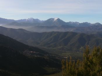
• Très beau sentier de crêtes entre le golfe de St Florent et la chaîne centrale. Bien ensoleillé.
![Excursión Senderismo Urtaca - san pancraziu urtaca - Photo](https://media.geolcdn.com/t/350/260/ext.jpg?maxdim=2&url=https%3A%2F%2Fstatic1.geolcdn.com%2Fsiteimages%2Fupload%2Ffiles%2F1553511878bg_sport_marche.png)
![Senderismo Senderismo](https://static1.geolcdn.com/sitytour/trail-icons/101.png)
Km
#3 - san pancraziu urtaca
Senderismo
Muy difícil
Urtaca,
Córcega,
Alta Córcega,
France
![](/images/other/stat-length.png)
10 km | 19,4 km-effort
3h 56min
![](https://static1.geolcdn.com/siteimages/upload/files/1508320355ic_sort_den_pos_24dp.png)
708 m
![](https://static1.geolcdn.com/siteimages/upload/files/1508320355ic_sort_den_neg_24dp.png)
706 m
![](https://static1.geolcdn.com/siteimages/upload/files/16400158638029165_repeat_loop_refresh_sync_direction_icon.png)
Sí
AS Piumberìa
3 excursiones mostradas en 3
Aplicación GPS de excursión GRATIS