![](/images/other/stat-length.png)
- Excursiones
- Outdoor
- Germany
- Renania-Palatinado
- Südwestpfalz
- Münchweiler an der Rodalb
Münchweiler an der Rodalb, Südwestpfalz: Los mejores itinerarios de excursión, recorridos, paseos y sendas
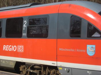
Münchweiler an der Rodalb: Descubra las mejores excursiones: 5 a pie. Todos estos circuitos, recorridos, itinerarios y actividades al aire libre están disponibles en nuestras aplicaciones SityTrail para smartphone y tablet.
Los mejores recorridos (5)
![Excursión A pie Münchweiler an der Rodalb - Felsenwaldtour - Photo](https://media.geolcdn.com/t/350/260/27ea1187-bd8b-4476-ae26-5025c4273908.jpeg&format=jpg&maxdim=2)
![A pie A pie](https://static1.geolcdn.com/sitytour/trail-icons/100.png)
Km
A pie
![](/images/other/stat-length.png)
![](https://static1.geolcdn.com/siteimages/upload/files/1508320355ic_sort_den_pos_24dp.png)
![](https://static1.geolcdn.com/siteimages/upload/files/1508320355ic_sort_den_neg_24dp.png)
![](https://static1.geolcdn.com/siteimages/upload/files/16400158638029165_repeat_loop_refresh_sync_direction_icon.png)
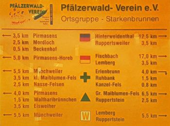
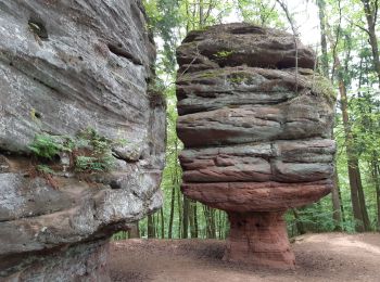
• Trail created by Stadt Pirmasens. Symbol: Stilisiertes rotes Felsentour auf weißem Grund
![Excursión A pie Münchweiler an der Rodalb - Münchweiler Höhenwanderweg - Photo](https://media.geolcdn.com/t/350/260/bbd39193-5a66-4d9f-be64-d7d175ff56e8.jpeg&format=jpg&maxdim=2)
![A pie A pie](https://static1.geolcdn.com/sitytour/trail-icons/100.png)
Km
A pie
![](/images/other/stat-length.png)
![](https://static1.geolcdn.com/siteimages/upload/files/1508320355ic_sort_den_pos_24dp.png)
![](https://static1.geolcdn.com/siteimages/upload/files/1508320355ic_sort_den_neg_24dp.png)
![](https://static1.geolcdn.com/siteimages/upload/files/16400158638029165_repeat_loop_refresh_sync_direction_icon.png)
• Symbol: Grünes H auf weißem Grund
![Excursión A pie Münchweiler an der Rodalb - DE-7 - Photo](https://media.geolcdn.com/t/350/260/070582bd-8e05-4f19-a255-4308f2490e36.jpeg&format=jpg&maxdim=2)
![A pie A pie](https://static1.geolcdn.com/sitytour/trail-icons/100.png)
Km
A pie
![](/images/other/stat-length.png)
![](https://static1.geolcdn.com/siteimages/upload/files/1508320355ic_sort_den_pos_24dp.png)
![](https://static1.geolcdn.com/siteimages/upload/files/1508320355ic_sort_den_neg_24dp.png)
![](https://static1.geolcdn.com/siteimages/upload/files/16400158638029165_repeat_loop_refresh_sync_direction_icon.png)
• Trail created by Pfälzerwaldverein Münchweiler. Symbol: Schwarze 7 auf weißem Grund
![Excursión Senderismo Münchweiler an der Rodalb - Felsenwald - Photo](https://media.geolcdn.com/t/350/260/405030d7-97d3-4f5f-ba79-d025ac7a07cb.jpg&format=jpg&maxdim=2)
![Senderismo Senderismo](https://static1.geolcdn.com/sitytour/trail-icons/101.png)
Km
Senderismo
![](/images/other/stat-length.png)
![](https://static1.geolcdn.com/siteimages/upload/files/1508320355ic_sort_den_pos_24dp.png)
![](https://static1.geolcdn.com/siteimages/upload/files/1508320355ic_sort_den_neg_24dp.png)
![](https://static1.geolcdn.com/siteimages/upload/files/16400158638029165_repeat_loop_refresh_sync_direction_icon.png)
![Excursión Senderismo Münchweiler an der Rodalb - Pirmasens - Felsenwald - Photo](https://media.geolcdn.com/t/350/260/5baf6c00-a6a3-46f6-9a28-4727ebd10360.jpg&format=jpg&maxdim=2)
![Senderismo Senderismo](https://static1.geolcdn.com/sitytour/trail-icons/101.png)
Km
Senderismo
![](/images/other/stat-length.png)
![](https://static1.geolcdn.com/siteimages/upload/files/1508320355ic_sort_den_pos_24dp.png)
![](https://static1.geolcdn.com/siteimages/upload/files/1508320355ic_sort_den_neg_24dp.png)
![](https://static1.geolcdn.com/siteimages/upload/files/16400158638029165_repeat_loop_refresh_sync_direction_icon.png)
5 excursiones mostradas en 5
Aplicación GPS de excursión GRATIS