![](/images/other/stat-length.png)
- Excursiones
- Outdoor
- Germany
- Renania-Palatinado
- Landkreis Mayen-Koblenz
- Kobern-Gondorf
Kobern-Gondorf, Landkreis Mayen-Koblenz: Los mejores itinerarios de excursión, recorridos, paseos y sendas
Kobern-Gondorf: Descubra las mejores excursiones: 3 a pie. Todos estos circuitos, recorridos, itinerarios y actividades al aire libre están disponibles en nuestras aplicaciones SityTrail para smartphone y tablet.
Los mejores recorridos (3)
![Excursión A pie Kobern-Gondorf - Tatzelwurmweg Kobern-Gondorf - Photo](https://media.geolcdn.com/t/350/260/e2354973-9d95-476c-92d4-c887535f5dc5.jpeg&format=jpg&maxdim=2)
![A pie A pie](https://static1.geolcdn.com/sitytour/trail-icons/100.png)
Km
A pie
![](/images/other/stat-length.png)
![](https://static1.geolcdn.com/siteimages/upload/files/1508320355ic_sort_den_pos_24dp.png)
![](https://static1.geolcdn.com/siteimages/upload/files/1508320355ic_sort_den_neg_24dp.png)
![](https://static1.geolcdn.com/siteimages/upload/files/16400158638029165_repeat_loop_refresh_sync_direction_icon.png)
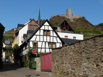
• Trail created by Touristik und Kultur Kobern-Gondorf, Lennigstraße 12, 56330 Kobern-Gondorf, Tel.: 02607/1055. Symbo...
![Excursión A pie Kobern-Gondorf - Koberner Burgweg - Photo](https://media.geolcdn.com/t/350/260/4672d2dc-ff5d-46db-9471-c1a528e4caed.jpeg&format=jpg&maxdim=2)
![A pie A pie](https://static1.geolcdn.com/sitytour/trail-icons/100.png)
Km
A pie
![](/images/other/stat-length.png)
![](https://static1.geolcdn.com/siteimages/upload/files/1508320355ic_sort_den_pos_24dp.png)
![](https://static1.geolcdn.com/siteimages/upload/files/1508320355ic_sort_den_neg_24dp.png)
![](https://static1.geolcdn.com/siteimages/upload/files/16400158638029165_repeat_loop_refresh_sync_direction_icon.png)
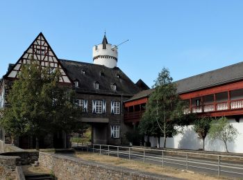
• Trail created by Projektbüro Traumpfade der Rhein-Mosel-Eifel-Touristik. Symbol: Orangener Hintergrund mit weißem We...
![Excursión Senderismo Kobern-Gondorf - Winningen 26 octobre 2024 - Photo](https://media.geolcdn.com/t/350/260/ext.jpg?maxdim=2&url=https%3A%2F%2Fstatic1.geolcdn.com%2Fsiteimages%2Fupload%2Ffiles%2F1553511878bg_sport_marche.png)
![Senderismo Senderismo](https://static1.geolcdn.com/sitytour/trail-icons/101.png)
Km
Senderismo
![](/images/other/stat-length.png)
![](https://static1.geolcdn.com/siteimages/upload/files/1508320355ic_sort_den_pos_24dp.png)
![](https://static1.geolcdn.com/siteimages/upload/files/1508320355ic_sort_den_neg_24dp.png)
![](https://static1.geolcdn.com/siteimages/upload/files/16400158638029165_repeat_loop_refresh_sync_direction_icon.png)
3 excursiones mostradas en 3
Aplicación GPS de excursión GRATIS