![](/images/other/stat-length.png)
- Excursiones
- A pie
- Italy
- Lombardía
- Lecco
- Lecco
Lecco, Lecco, A pie: Los mejores itinerarios de excursión, recorridos, paseos y sendas
Lecco: Descubra las mejores excursiones: 8 a pie. Todos estos circuitos, recorridos, itinerarios y actividades al aire libre están disponibles en nuestras aplicaciones SityTrail para smartphone y tablet.
Los mejores recorridos (8)
![Excursión A pie Lecco - Sentiero 2 della Val Calolden - Photo](https://media.geolcdn.com/t/350/260/6a9d73e2-be77-4099-a255-f8b347ac14ac.jpeg&format=jpg&maxdim=2)
![A pie A pie](https://static1.geolcdn.com/sitytour/trail-icons/100.png)
Km
A pie
![](/images/other/stat-length.png)
![](https://static1.geolcdn.com/siteimages/upload/files/1508320355ic_sort_den_pos_24dp.png)
![](https://static1.geolcdn.com/siteimages/upload/files/1508320355ic_sort_den_neg_24dp.png)
![](https://static1.geolcdn.com/siteimages/upload/files/16400158638029165_repeat_loop_refresh_sync_direction_icon.png)
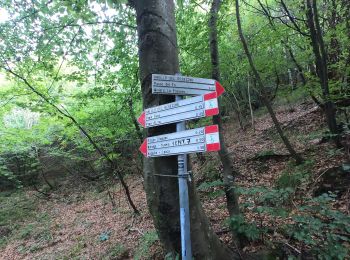
• Trail created by S.E.L.. Symbol: red-white-yellow bars with the black text "2" on the white bar
![Excursión A pie Lecco - Percorso Giorgio Combi - Photo](https://media.geolcdn.com/t/350/260/48ecfc1f-868d-4b17-879f-6b7b4f7605e2.jpeg&format=jpg&maxdim=2)
![A pie A pie](https://static1.geolcdn.com/sitytour/trail-icons/100.png)
Km
A pie
![](/images/other/stat-length.png)
![](https://static1.geolcdn.com/siteimages/upload/files/1508320355ic_sort_den_pos_24dp.png)
![](https://static1.geolcdn.com/siteimages/upload/files/1508320355ic_sort_den_neg_24dp.png)
![](https://static1.geolcdn.com/siteimages/upload/files/16400158638029165_repeat_loop_refresh_sync_direction_icon.png)
• Trail created by APE Lecco. Symbol: yellow markers and yellow metal plates with text "PERCORSO GIORGIO COMBI"
![Excursión A pie Lecco - Sentiero 18 (della Corna Cammello): Versasio - Piani d'Erna - Photo](https://media.geolcdn.com/t/350/260/8ce93a6f-64ae-432f-a2ee-6859572d3ed1.jpeg&format=jpg&maxdim=2)
![A pie A pie](https://static1.geolcdn.com/sitytour/trail-icons/100.png)
Km
A pie
![](/images/other/stat-length.png)
![](https://static1.geolcdn.com/siteimages/upload/files/1508320355ic_sort_den_pos_24dp.png)
![](https://static1.geolcdn.com/siteimages/upload/files/1508320355ic_sort_den_neg_24dp.png)
![](https://static1.geolcdn.com/siteimages/upload/files/16400158638029165_repeat_loop_refresh_sync_direction_icon.png)
• Trail created by S.E.L.. Symbol: red-white-yellow vertical bars with the black text "18"; sometimes a red square wit...
![Excursión A pie Lecco - Sentiero Rotary Lecco - Photo](https://media.geolcdn.com/t/350/260/506e0fb4-71e0-4999-80b7-823fec58a496.jpeg&format=jpg&maxdim=2)
![A pie A pie](https://static1.geolcdn.com/sitytour/trail-icons/100.png)
Km
A pie
![](/images/other/stat-length.png)
![](https://static1.geolcdn.com/siteimages/upload/files/1508320355ic_sort_den_pos_24dp.png)
![](https://static1.geolcdn.com/siteimages/upload/files/1508320355ic_sort_den_neg_24dp.png)
![](https://static1.geolcdn.com/siteimages/upload/files/16400158638029165_repeat_loop_refresh_sync_direction_icon.png)
• Trail created by Rotary Lecco. Symbol: cogwheel with text "ROTARY INTERNATIONAL", trail paint blaze red-white stripes
![Excursión A pie Lecco - Sentiero 1: Malnago - Rifugio Azzoni - Photo](https://media.geolcdn.com/t/350/260/9a4f72b8-2e20-4aca-b019-42666e843664.jpeg&format=jpg&maxdim=2)
![A pie A pie](https://static1.geolcdn.com/sitytour/trail-icons/100.png)
Km
A pie
![](/images/other/stat-length.png)
![](https://static1.geolcdn.com/siteimages/upload/files/1508320355ic_sort_den_pos_24dp.png)
![](https://static1.geolcdn.com/siteimages/upload/files/1508320355ic_sort_den_neg_24dp.png)
![](https://static1.geolcdn.com/siteimages/upload/files/16400158638029165_repeat_loop_refresh_sync_direction_icon.png)
• Trail created by S.E.L.. Symbol: red-white-yellow vertical bars with the black text "1"
![Excursión A pie Lecco - Antica Strada Comunale di Morterone - Photo](https://media.geolcdn.com/t/350/260/1394526c-d121-4e6f-9acb-22649a9ee7d6.jpeg&format=jpg&maxdim=2)
![A pie A pie](https://static1.geolcdn.com/sitytour/trail-icons/100.png)
Km
A pie
![](/images/other/stat-length.png)
![](https://static1.geolcdn.com/siteimages/upload/files/1508320355ic_sort_den_pos_24dp.png)
![](https://static1.geolcdn.com/siteimages/upload/files/1508320355ic_sort_den_neg_24dp.png)
![](https://static1.geolcdn.com/siteimages/upload/files/16400158638029165_repeat_loop_refresh_sync_direction_icon.png)
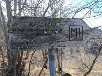
• Symbol: red square with black text "M1"
![Excursión A pie Lecco - Anello del Resegone - Photo](https://media.geolcdn.com/t/350/260/05e0c133-dab2-4e98-bc0a-302f1a1550eb.jpeg&format=jpg&maxdim=2)
![A pie A pie](https://static1.geolcdn.com/sitytour/trail-icons/100.png)
Km
A pie
![](/images/other/stat-length.png)
![](https://static1.geolcdn.com/siteimages/upload/files/1508320355ic_sort_den_pos_24dp.png)
![](https://static1.geolcdn.com/siteimages/upload/files/1508320355ic_sort_den_neg_24dp.png)
![](https://static1.geolcdn.com/siteimages/upload/files/16400158638029165_repeat_loop_refresh_sync_direction_icon.png)
• Trail created by Progetto Lario.
![Excursión A pie Lecco - Sentiero 21: Erna - Artavaggio - Photo](https://media.geolcdn.com/t/350/260/316d5b51-7c63-49ef-b75b-c49157a4c054.jpeg&format=jpg&maxdim=2)
![A pie A pie](https://static1.geolcdn.com/sitytour/trail-icons/100.png)
Km
A pie
![](/images/other/stat-length.png)
![](https://static1.geolcdn.com/siteimages/upload/files/1508320355ic_sort_den_pos_24dp.png)
![](https://static1.geolcdn.com/siteimages/upload/files/1508320355ic_sort_den_neg_24dp.png)
![](https://static1.geolcdn.com/siteimages/upload/files/16400158638029165_repeat_loop_refresh_sync_direction_icon.png)
• Trail created by Società Escursionisti Lecchesi. Symbol: depends on trail section: blazes red-white-yellow vertical ...
8 excursiones mostradas en 8
Aplicación GPS de excursión GRATIS