


4,4 km | 5,8 km-effort
County Tipperary: Descubra las mejores excursiones: 1 a pie, 25 senderismo y 3 carrera. Todos estos circuitos, recorridos, itinerarios y actividades al aire libre están disponibles en nuestras aplicaciones SityTrail para smartphone y tablet.
A pie


Senderismo
• Hard walk
Senderismo
Senderismo
Senderismo
Senderismo
•

Senderismo
• MORONEYS BAR LISVERNANE CO TIPPERARY Moroneys is a family run bar in the family with over 150 yrs. It is a old style ...

Carrera
• A-B. From the mapboard in the green area at Christ the King statue follow downhill to enter the Nature Park. This loo...
Carrera
• A-B. From the mapboard in the green area at Christ the King statue follow downhill to enter the Nature Park. This loo...
Carrera
• A-B. From the mapboard in the green area climb onto the road and go to the Christ the King statue. Follow the blue ar...
Senderismo
• This very successful walking marathon, held annually on Palm Sunday and now in its fourth year, provides a unique opp...
Senderismo
• Slievenamuck Walking Marathon Sunday March 24th 2013This very successful walking marathon, held annually on Palm Sund...
Senderismo
• Walk
Senderismo
•
Senderismo
• A-B. From the mapboard in the green area climb onto the road and go to the Christ the King statue. Follow the red arr...
Senderismo
• OPEN MOORE LAND
Senderismo
•
Senderismo
•
Senderismo
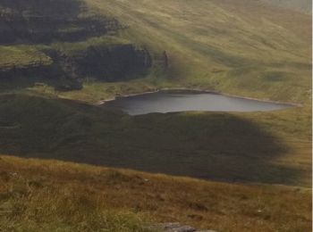
• 5 Lakes view on 6 Mountain peaks in the galtees
Senderismo
• 5 Lakes view on 6 Mountain peaks in the galtees
20 excursiones mostradas en 29
Aplicación GPS de excursión GRATIS
 SityTrail
IGN / Institutos geográficos
SityTrail World
El mundo es suyo