![](/images/other/stat-length.png)
- Excursiones
- A pie
- Germany
- Hesse
- Main-Kinzig-Kreis
- Biebergemünd
Biebergemünd, Main-Kinzig-Kreis, A pie: Los mejores itinerarios de excursión, recorridos, paseos y sendas
Biebergemünd: Descubra las mejores excursiones: 8 a pie. Todos estos circuitos, recorridos, itinerarios y actividades al aire libre están disponibles en nuestras aplicaciones SityTrail para smartphone y tablet.
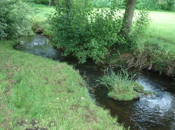
Los mejores recorridos (8)
![Excursión A pie Biebergemünd - Spessartspuren - Bieber - Photo](https://media.geolcdn.com/t/350/260/62cb8d3f-1937-4ed4-9d97-142b12397164.jpeg&format=jpg&maxdim=2)
![A pie A pie](https://static1.geolcdn.com/sitytour/trail-icons/100.png)
Km
A pie
![](/images/other/stat-length.png)
![](https://static1.geolcdn.com/siteimages/upload/files/1508320355ic_sort_den_pos_24dp.png)
![](https://static1.geolcdn.com/siteimages/upload/files/1508320355ic_sort_den_neg_24dp.png)
![](https://static1.geolcdn.com/siteimages/upload/files/16400158638029165_repeat_loop_refresh_sync_direction_icon.png)
• Trail created by Naturpark Hessischer Spessart. Symbol: Blauer Strich und grüner Bogen über gelbem Rechteck auf hell...
![Excursión A pie Biebergemünd - Biebergemünd - Rundwanderweg Bg 3 - Photo](https://media.geolcdn.com/t/350/260/bce28cba-1c4f-44e4-b4c8-5bb93a0699a6.jpeg&format=jpg&maxdim=2)
![A pie A pie](https://static1.geolcdn.com/sitytour/trail-icons/100.png)
Km
A pie
![](/images/other/stat-length.png)
![](https://static1.geolcdn.com/siteimages/upload/files/1508320355ic_sort_den_pos_24dp.png)
![](https://static1.geolcdn.com/siteimages/upload/files/1508320355ic_sort_den_neg_24dp.png)
![](https://static1.geolcdn.com/siteimages/upload/files/16400158638029165_repeat_loop_refresh_sync_direction_icon.png)
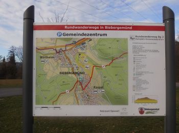
• Trail created by Naturpark Spessart;Gemeinde Biebergemünd. Symbol: Bg3 in schwarz auf weißem Hintergrund
![Excursión A pie Biebergemünd - Biebergemünd - Rundwanderweg Bg 1 - Photo](https://media.geolcdn.com/t/350/260/0c3b2e2d-97d1-459a-820a-68ab605d7252.jpeg&format=jpg&maxdim=2)
![A pie A pie](https://static1.geolcdn.com/sitytour/trail-icons/100.png)
Km
A pie
![](/images/other/stat-length.png)
![](https://static1.geolcdn.com/siteimages/upload/files/1508320355ic_sort_den_pos_24dp.png)
![](https://static1.geolcdn.com/siteimages/upload/files/1508320355ic_sort_den_neg_24dp.png)
![](https://static1.geolcdn.com/siteimages/upload/files/16400158638029165_repeat_loop_refresh_sync_direction_icon.png)
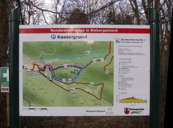
• Trail created by Naturpark Spessart;Gemeinde Biebergemünd. Symbol: Bg1 in schwarz auf weißem Hintergrund
![Excursión A pie Biebergemünd - Biebergemünd - Rundwanderweg Bg 2 - Photo](https://media.geolcdn.com/t/350/260/104b84aa-6517-422b-ac20-a2aea28e3a13.jpeg&format=jpg&maxdim=2)
![A pie A pie](https://static1.geolcdn.com/sitytour/trail-icons/100.png)
Km
A pie
![](/images/other/stat-length.png)
![](https://static1.geolcdn.com/siteimages/upload/files/1508320355ic_sort_den_pos_24dp.png)
![](https://static1.geolcdn.com/siteimages/upload/files/1508320355ic_sort_den_neg_24dp.png)
![](https://static1.geolcdn.com/siteimages/upload/files/16400158638029165_repeat_loop_refresh_sync_direction_icon.png)
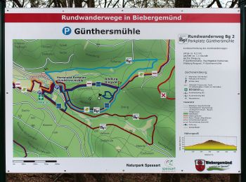
• Trail created by Naturpark Spessart;Gemeinde Biebergemünd. Symbol: Bg2 in schwarz auf weißem Hintergrund
![Excursión A pie Biebergemünd - Spessartbogen Zubringer Roßbach - Breitenborn - Photo](https://media.geolcdn.com/t/350/260/0fee88fb-ff19-432e-becf-3384decb3417.jpeg&format=jpg&maxdim=2)
![A pie A pie](https://static1.geolcdn.com/sitytour/trail-icons/100.png)
Km
A pie
![](/images/other/stat-length.png)
![](https://static1.geolcdn.com/siteimages/upload/files/1508320355ic_sort_den_pos_24dp.png)
![](https://static1.geolcdn.com/siteimages/upload/files/1508320355ic_sort_den_neg_24dp.png)
![](https://static1.geolcdn.com/siteimages/upload/files/16400158638029165_repeat_loop_refresh_sync_direction_icon.png)
• Trail created by Naturpark Hessischer Spessart. Der Wegeverlauf hat sich ab der Kaisereiche geändert! Symbol: dunke...
![Excursión A pie Biebergemünd - Kulturweg Biebergemünd 2 - Photo](https://media.geolcdn.com/t/350/260/0c3b2e2d-97d1-459a-820a-68ab605d7252.jpeg&format=jpg&maxdim=2)
![A pie A pie](https://static1.geolcdn.com/sitytour/trail-icons/100.png)
Km
A pie
![](/images/other/stat-length.png)
![](https://static1.geolcdn.com/siteimages/upload/files/1508320355ic_sort_den_pos_24dp.png)
![](https://static1.geolcdn.com/siteimages/upload/files/1508320355ic_sort_den_neg_24dp.png)
![](https://static1.geolcdn.com/siteimages/upload/files/16400158638029165_repeat_loop_refresh_sync_direction_icon.png)
• Trail created by Archäologisches Spessartprojekt. Symbol: Gelbes EU-Schiffchen auf blauem Grund
![Excursión A pie Biebergemünd - Kulturweg Biebergemünd 1 - Photo](https://media.geolcdn.com/t/350/260/f572fa30-e08a-4645-9d7d-2b6b71accb1f.jpeg&format=jpg&maxdim=2)
![A pie A pie](https://static1.geolcdn.com/sitytour/trail-icons/100.png)
Km
A pie
![](/images/other/stat-length.png)
![](https://static1.geolcdn.com/siteimages/upload/files/1508320355ic_sort_den_pos_24dp.png)
![](https://static1.geolcdn.com/siteimages/upload/files/1508320355ic_sort_den_neg_24dp.png)
![](https://static1.geolcdn.com/siteimages/upload/files/16400158638029165_repeat_loop_refresh_sync_direction_icon.png)
• Trail created by Archäologisches Spessartprojekt. Symbol: Gelbes EU-Schiffchen auf blauem Grund Sitio web: https:/...
![Excursión A pie Biebergemünd - Hossewies'chen: Schnepfe - Photo](https://media.geolcdn.com/t/350/260/49ca7a57-f1e1-4ddd-8369-88fed5da3d84.jpeg&format=jpg&maxdim=2)
![A pie A pie](https://static1.geolcdn.com/sitytour/trail-icons/100.png)
Km
A pie
![](/images/other/stat-length.png)
![](https://static1.geolcdn.com/siteimages/upload/files/1508320355ic_sort_den_pos_24dp.png)
![](https://static1.geolcdn.com/siteimages/upload/files/1508320355ic_sort_den_neg_24dp.png)
![](https://static1.geolcdn.com/siteimages/upload/files/16400158638029165_repeat_loop_refresh_sync_direction_icon.png)
• Trail created by Naturpark Spessart. Symbol: Rote Schnepfe auf weißem Grund
8 excursiones mostradas en 8