![](/images/other/stat-length.png)
- Excursiones
- A pie
- Germany
- Renania-Palatinado
- Südwestpfalz
- Wilgartswiesen
Wilgartswiesen, Südwestpfalz, A pie: Los mejores itinerarios de excursión, recorridos, paseos y sendas
Wilgartswiesen: Descubra las mejores excursiones: 6 a pie. Todos estos circuitos, recorridos, itinerarios y actividades al aire libre están disponibles en nuestras aplicaciones SityTrail para smartphone y tablet.
Los mejores recorridos (6)
![Excursión A pie Wilgartswiesen - Hauensteiner Nr. 22 - Photo](https://media.geolcdn.com/t/350/260/bfc1c8ab-f206-4cef-af6c-a5bb6220458a.jpeg&format=jpg&maxdim=2)
![A pie A pie](https://static1.geolcdn.com/sitytour/trail-icons/100.png)
Km
A pie
![](/images/other/stat-length.png)
![](https://static1.geolcdn.com/siteimages/upload/files/1508320355ic_sort_den_pos_24dp.png)
![](https://static1.geolcdn.com/siteimages/upload/files/1508320355ic_sort_den_neg_24dp.png)
![](https://static1.geolcdn.com/siteimages/upload/files/16400158638029165_repeat_loop_refresh_sync_direction_icon.png)
• Trail created by Pfälzerwaldverein Hauenstein. Symbol: Schwarze 22 auf weißem Grund
![Excursión A pie Wilgartswiesen - Wilgartswieser Biosphären-Pfad - Photo](https://media.geolcdn.com/t/350/260/66a21bc8-09b6-492e-84d4-54fa6a9ccdf4.jpeg&format=jpg&maxdim=2)
![A pie A pie](https://static1.geolcdn.com/sitytour/trail-icons/100.png)
Km
A pie
![](/images/other/stat-length.png)
![](https://static1.geolcdn.com/siteimages/upload/files/1508320355ic_sort_den_pos_24dp.png)
![](https://static1.geolcdn.com/siteimages/upload/files/1508320355ic_sort_den_neg_24dp.png)
![](https://static1.geolcdn.com/siteimages/upload/files/16400158638029165_repeat_loop_refresh_sync_direction_icon.png)
• Symbol: grüne Spirale auf weißem Grund
![Excursión A pie Wilgartswiesen - Wilgartswieser Burgen-Tour - Photo](https://media.geolcdn.com/t/350/260/66a21bc8-09b6-492e-84d4-54fa6a9ccdf4.jpeg&format=jpg&maxdim=2)
![A pie A pie](https://static1.geolcdn.com/sitytour/trail-icons/100.png)
Km
A pie
![](/images/other/stat-length.png)
![](https://static1.geolcdn.com/siteimages/upload/files/1508320355ic_sort_den_pos_24dp.png)
![](https://static1.geolcdn.com/siteimages/upload/files/1508320355ic_sort_den_neg_24dp.png)
![](https://static1.geolcdn.com/siteimages/upload/files/16400158638029165_repeat_loop_refresh_sync_direction_icon.png)
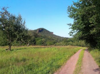
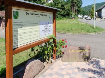
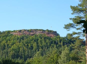
• Symbol: schwarze stilisierte Burg auf weißem Grund
![Excursión A pie Wilgartswiesen - Rundweg F Wilgartswiesen - Photo](https://media.geolcdn.com/t/350/260/76909985-f0a9-4094-9c53-aff47d1f17b7.jpeg&format=jpg&maxdim=2)
![A pie A pie](https://static1.geolcdn.com/sitytour/trail-icons/100.png)
Km
A pie
![](/images/other/stat-length.png)
![](https://static1.geolcdn.com/siteimages/upload/files/1508320355ic_sort_den_pos_24dp.png)
![](https://static1.geolcdn.com/siteimages/upload/files/1508320355ic_sort_den_neg_24dp.png)
![](https://static1.geolcdn.com/siteimages/upload/files/16400158638029165_repeat_loop_refresh_sync_direction_icon.png)
• Trail created by Pfälzerwald-Verein Wilgartswiesen. Symbol: Schwarzes F auf weißem Grund
![Excursión A pie Wilgartswiesen - Rundweg D Wilgartswiesen - Photo](https://media.geolcdn.com/t/350/260/76909985-f0a9-4094-9c53-aff47d1f17b7.jpeg&format=jpg&maxdim=2)
![A pie A pie](https://static1.geolcdn.com/sitytour/trail-icons/100.png)
Km
A pie
![](/images/other/stat-length.png)
![](https://static1.geolcdn.com/siteimages/upload/files/1508320355ic_sort_den_pos_24dp.png)
![](https://static1.geolcdn.com/siteimages/upload/files/1508320355ic_sort_den_neg_24dp.png)
![](https://static1.geolcdn.com/siteimages/upload/files/16400158638029165_repeat_loop_refresh_sync_direction_icon.png)
• Trail created by Pfälzerwald-Verein Wilgartswiesen. Symbol: Schwarzes D auf weißem Grund
![Excursión A pie Wilgartswiesen - Rundweg B Wilgartswiesen - Photo](https://media.geolcdn.com/t/350/260/ext.jpg?maxdim=2&url=https%3A%2F%2Fstatic1.geolcdn.com%2Fsiteimages%2Fupload%2Ffiles%2F1545311037marcheuse_200dpi.jpg)
![A pie A pie](https://static1.geolcdn.com/sitytour/trail-icons/100.png)
Km
A pie
![](/images/other/stat-length.png)
![](https://static1.geolcdn.com/siteimages/upload/files/1508320355ic_sort_den_pos_24dp.png)
![](https://static1.geolcdn.com/siteimages/upload/files/1508320355ic_sort_den_neg_24dp.png)
![](https://static1.geolcdn.com/siteimages/upload/files/16400158638029165_repeat_loop_refresh_sync_direction_icon.png)
• Trail created by Pfälzerwald-Verein Wilgartswiesen. diverse Abkürzungen ausgeschildert Symbol: Schwarzes B auf weiß...
6 excursiones mostradas en 6
Aplicación GPS de excursión GRATIS