![](/images/other/stat-length.png)
- Excursiones
- A pie
- Germany
- Renania-Palatinado
- Rhein-Hunsrück-Kreis
Rhein-Hunsrück-Kreis, Renania-Palatinado, A pie: Los mejores itinerarios de excursión, recorridos, paseos y sendas
Rhein-Hunsrück-Kreis: Descubra las mejores excursiones: 36 a pie y 12 senderismo. Todos estos circuitos, recorridos, itinerarios y actividades al aire libre están disponibles en nuestras aplicaciones SityTrail para smartphone y tablet.
Los mejores recorridos (48)
![Excursión Senderismo Mörsdorf - pont suspendu de Geierlay - Photo](https://media.geolcdn.com/t/350/260/864ecd12-4eaf-47c6-a99d-cc6e483e3fd9.jpg&format=jpg&maxdim=2)
![Senderismo Senderismo](https://static1.geolcdn.com/sitytour/trail-icons/101.png)
Km
Senderismo
![](/images/other/stat-length.png)
![](https://static1.geolcdn.com/siteimages/upload/files/1508320355ic_sort_den_pos_24dp.png)
![](https://static1.geolcdn.com/siteimages/upload/files/1508320355ic_sort_den_neg_24dp.png)
![](https://static1.geolcdn.com/siteimages/upload/files/16400158638029165_repeat_loop_refresh_sync_direction_icon.png)
![Excursión Senderismo Mörsdorf - Promenade vers le pont de Geierlay - Photo](https://media.geolcdn.com/t/350/260/0d007229-5338-45e8-9509-5159d63bf2a7.jpg&format=jpg&maxdim=2)
![Senderismo Senderismo](https://static1.geolcdn.com/sitytour/trail-icons/101.png)
Km
Senderismo
![](/images/other/stat-length.png)
![](https://static1.geolcdn.com/siteimages/upload/files/1508320355ic_sort_den_pos_24dp.png)
![](https://static1.geolcdn.com/siteimages/upload/files/1508320355ic_sort_den_neg_24dp.png)
![](https://static1.geolcdn.com/siteimages/upload/files/16400158638029165_repeat_loop_refresh_sync_direction_icon.png)
![Excursión A pie Niedert - Traumschleife Oberes Baybachtal - Photo](https://media.geolcdn.com/t/350/260/2c245e26-d5a8-4dbd-bad2-ca9203136393.jpeg&format=jpg&maxdim=2)
![A pie A pie](https://static1.geolcdn.com/sitytour/trail-icons/100.png)
Km
A pie
![](/images/other/stat-length.png)
![](https://static1.geolcdn.com/siteimages/upload/files/1508320355ic_sort_den_pos_24dp.png)
![](https://static1.geolcdn.com/siteimages/upload/files/1508320355ic_sort_den_neg_24dp.png)
![](https://static1.geolcdn.com/siteimages/upload/files/16400158638029165_repeat_loop_refresh_sync_direction_icon.png)
• Symbol: stilisiertes S und H auf lila Grund
![Excursión A pie Boppard - Traumschleife Rheingold - Photo](https://media.geolcdn.com/t/350/260/8437e446-2f43-4571-a9e9-1985d3cf142a.jpeg&format=jpg&maxdim=2)
![A pie A pie](https://static1.geolcdn.com/sitytour/trail-icons/100.png)
Km
A pie
![](/images/other/stat-length.png)
![](https://static1.geolcdn.com/siteimages/upload/files/1508320355ic_sort_den_pos_24dp.png)
![](https://static1.geolcdn.com/siteimages/upload/files/1508320355ic_sort_den_neg_24dp.png)
![](https://static1.geolcdn.com/siteimages/upload/files/16400158638029165_repeat_loop_refresh_sync_direction_icon.png)
• Symbol: weiß auf violett: Von den Zinnen eines Burgturmes gekröntes R
![Excursión A pie Mengerschied - Traumschleife Soonwald - Photo](https://media.geolcdn.com/t/350/260/05861b49-ac78-4214-b70c-b3a57214a51c.jpeg&format=jpg&maxdim=2)
![A pie A pie](https://static1.geolcdn.com/sitytour/trail-icons/100.png)
Km
A pie
![](/images/other/stat-length.png)
![](https://static1.geolcdn.com/siteimages/upload/files/1508320355ic_sort_den_pos_24dp.png)
![](https://static1.geolcdn.com/siteimages/upload/files/1508320355ic_sort_den_neg_24dp.png)
![](https://static1.geolcdn.com/siteimages/upload/files/16400158638029165_repeat_loop_refresh_sync_direction_icon.png)
• Trail created by Verbandsgemeinde Simmern-Rheinböllen. Sitio web: https://www.saar-hunsrueck-steig.de/traumschleif...
![Excursión A pie Argenthal - Traumschleife Schanzerkopf-Tour - Photo](https://media.geolcdn.com/t/350/260/0a3cefcd-fd4a-4a36-a19e-f792806739d8.jpeg&format=jpg&maxdim=2)
![A pie A pie](https://static1.geolcdn.com/sitytour/trail-icons/100.png)
Km
A pie
![](/images/other/stat-length.png)
![](https://static1.geolcdn.com/siteimages/upload/files/1508320355ic_sort_den_pos_24dp.png)
![](https://static1.geolcdn.com/siteimages/upload/files/1508320355ic_sort_den_neg_24dp.png)
![](https://static1.geolcdn.com/siteimages/upload/files/16400158638029165_repeat_loop_refresh_sync_direction_icon.png)
• Trail created by Verbandsgemeinde Simmern-Rheinböllen. Symbol: rechteckiges, violettes Schild, weiß Beschriftet: Obe...
![Excursión A pie Mörsdorf - Schieferhöhlen-Runde - Photo](https://media.geolcdn.com/t/350/260/031404a8-6053-492c-aeca-9b1c706317e9.jpeg&format=jpg&maxdim=2)
![A pie A pie](https://static1.geolcdn.com/sitytour/trail-icons/100.png)
Km
A pie
![](/images/other/stat-length.png)
![](https://static1.geolcdn.com/siteimages/upload/files/1508320355ic_sort_den_pos_24dp.png)
![](https://static1.geolcdn.com/siteimages/upload/files/1508320355ic_sort_den_neg_24dp.png)
![](https://static1.geolcdn.com/siteimages/upload/files/16400158638029165_repeat_loop_refresh_sync_direction_icon.png)
• Trail created by Wander- und Naturfreunde Mörsdorf e.V.. Symbol: Höhle
![Excursión A pie Mörsdorf - Rabenlay-Runde - Photo](https://media.geolcdn.com/t/350/260/c20de6d5-e985-4d24-9e2b-cd50cd5fbbfc.jpeg&format=jpg&maxdim=2)
![A pie A pie](https://static1.geolcdn.com/sitytour/trail-icons/100.png)
Km
A pie
![](/images/other/stat-length.png)
![](https://static1.geolcdn.com/siteimages/upload/files/1508320355ic_sort_den_pos_24dp.png)
![](https://static1.geolcdn.com/siteimages/upload/files/1508320355ic_sort_den_neg_24dp.png)
![](https://static1.geolcdn.com/siteimages/upload/files/16400158638029165_repeat_loop_refresh_sync_direction_icon.png)
• Trail created by Wander- und Naturfreunde Mörsdorf e.V.. Symbol: Rabe
![Excursión A pie Mörsdorf - Große Dachskaul-Runde - Photo](https://media.geolcdn.com/t/350/260/c20de6d5-e985-4d24-9e2b-cd50cd5fbbfc.jpeg&format=jpg&maxdim=2)
![A pie A pie](https://static1.geolcdn.com/sitytour/trail-icons/100.png)
Km
A pie
![](/images/other/stat-length.png)
![](https://static1.geolcdn.com/siteimages/upload/files/1508320355ic_sort_den_pos_24dp.png)
![](https://static1.geolcdn.com/siteimages/upload/files/1508320355ic_sort_den_neg_24dp.png)
![](https://static1.geolcdn.com/siteimages/upload/files/16400158638029165_repeat_loop_refresh_sync_direction_icon.png)
• Trail created by Wander- und Naturfreunde Mörsdorf e.V.. Symbol: Dachskopf
![Excursión A pie Mörsdorf - Kleine Dachskaul-Runde - Photo](https://media.geolcdn.com/t/350/260/c20de6d5-e985-4d24-9e2b-cd50cd5fbbfc.jpeg&format=jpg&maxdim=2)
![A pie A pie](https://static1.geolcdn.com/sitytour/trail-icons/100.png)
Km
A pie
![](/images/other/stat-length.png)
![](https://static1.geolcdn.com/siteimages/upload/files/1508320355ic_sort_den_pos_24dp.png)
![](https://static1.geolcdn.com/siteimages/upload/files/1508320355ic_sort_den_neg_24dp.png)
![](https://static1.geolcdn.com/siteimages/upload/files/16400158638029165_repeat_loop_refresh_sync_direction_icon.png)
• Trail created by Wander- und Naturfreunde Mörsdorf e.V.. Symbol: Dachs
![Excursión A pie Mörsdorf - 4-Bäche-Runde - Photo](https://media.geolcdn.com/t/350/260/c20de6d5-e985-4d24-9e2b-cd50cd5fbbfc.jpeg&format=jpg&maxdim=2)
![A pie A pie](https://static1.geolcdn.com/sitytour/trail-icons/100.png)
Km
A pie
![](/images/other/stat-length.png)
![](https://static1.geolcdn.com/siteimages/upload/files/1508320355ic_sort_den_pos_24dp.png)
![](https://static1.geolcdn.com/siteimages/upload/files/1508320355ic_sort_den_neg_24dp.png)
![](https://static1.geolcdn.com/siteimages/upload/files/16400158638029165_repeat_loop_refresh_sync_direction_icon.png)
• Trail created by Wander- und Naturfreunde Mörsdorf e.V.. Symbol: Geschwungene Liene
![Excursión A pie Mörsdorf - Bergkreuz-Runde - Photo](https://media.geolcdn.com/t/350/260/c20de6d5-e985-4d24-9e2b-cd50cd5fbbfc.jpeg&format=jpg&maxdim=2)
![A pie A pie](https://static1.geolcdn.com/sitytour/trail-icons/100.png)
Km
A pie
![](/images/other/stat-length.png)
![](https://static1.geolcdn.com/siteimages/upload/files/1508320355ic_sort_den_pos_24dp.png)
![](https://static1.geolcdn.com/siteimages/upload/files/1508320355ic_sort_den_neg_24dp.png)
![](https://static1.geolcdn.com/siteimages/upload/files/16400158638029165_repeat_loop_refresh_sync_direction_icon.png)
• Trail created by Wander- und Naturfreunde Mörsdorf e.V.. Symbol: Bergrelief mit Kreuz
![Excursión A pie Gehlweiler - Traumschleife Heimat - Photo](https://media.geolcdn.com/t/350/260/fc7eb9ae-1059-4a12-aa93-ccc4ca000d6b.jpeg&format=jpg&maxdim=2)
![A pie A pie](https://static1.geolcdn.com/sitytour/trail-icons/100.png)
Km
A pie
![](/images/other/stat-length.png)
![](https://static1.geolcdn.com/siteimages/upload/files/1508320355ic_sort_den_pos_24dp.png)
![](https://static1.geolcdn.com/siteimages/upload/files/1508320355ic_sort_den_neg_24dp.png)
![](https://static1.geolcdn.com/siteimages/upload/files/16400158638029165_repeat_loop_refresh_sync_direction_icon.png)
• Trail created by VG Kirchberg.
![Excursión A pie Boppard - Traumschleife Marienberg - Photo](https://media.geolcdn.com/t/350/260/4ce89ddc-05da-4825-84b5-a9dc0e82caf7.jpeg&format=jpg&maxdim=2)
![A pie A pie](https://static1.geolcdn.com/sitytour/trail-icons/100.png)
Km
A pie
![](/images/other/stat-length.png)
![](https://static1.geolcdn.com/siteimages/upload/files/1508320355ic_sort_den_pos_24dp.png)
![](https://static1.geolcdn.com/siteimages/upload/files/1508320355ic_sort_den_neg_24dp.png)
![](https://static1.geolcdn.com/siteimages/upload/files/16400158638029165_repeat_loop_refresh_sync_direction_icon.png)
• Symbol: rechteckiges, violettes Schild, weiß Beschriftet: Oben geschwungen "Traumschleifen", darunter, groß, die vers...
![Excursión A pie Sohren - Gedichte Pfad Sohren - Photo](https://media.geolcdn.com/t/350/260/5da5ebc2-8b1a-491f-b950-482ba43132d5.jpeg&format=jpg&maxdim=2)
![A pie A pie](https://static1.geolcdn.com/sitytour/trail-icons/100.png)
Km
A pie
![](/images/other/stat-length.png)
![](https://static1.geolcdn.com/siteimages/upload/files/1508320355ic_sort_den_pos_24dp.png)
![](https://static1.geolcdn.com/siteimages/upload/files/1508320355ic_sort_den_neg_24dp.png)
![](https://static1.geolcdn.com/siteimages/upload/files/16400158638029165_repeat_loop_refresh_sync_direction_icon.png)
• Trail created by Ortsgemeinde Sohren. Symbol: Gedichte Pfad Sohren mit Tintnfass und Schreibfeder
![Excursión A pie Emmelshausen - Hunsrückbahn-Wanderweg - Photo](https://media.geolcdn.com/t/350/260/99dda55e-d044-4e3c-909a-b2ae4f731413.jpeg&format=jpg&maxdim=2)
![A pie A pie](https://static1.geolcdn.com/sitytour/trail-icons/100.png)
Km
A pie
![](/images/other/stat-length.png)
![](https://static1.geolcdn.com/siteimages/upload/files/1508320355ic_sort_den_pos_24dp.png)
![](https://static1.geolcdn.com/siteimages/upload/files/1508320355ic_sort_den_neg_24dp.png)
![](https://static1.geolcdn.com/siteimages/upload/files/16400158638029165_repeat_loop_refresh_sync_direction_icon.png)
• Symbol: schwarze Bahn auf schwarzem Viadukt vor grüner Landschaft
![Excursión A pie Oberwesel - Schwede-Bure-Tour - Photo](https://media.geolcdn.com/t/350/260/d95036a5-8bfe-4709-a32c-8d3e87b64698.jpeg&format=jpg&maxdim=2)
![A pie A pie](https://static1.geolcdn.com/sitytour/trail-icons/100.png)
Km
A pie
![](/images/other/stat-length.png)
![](https://static1.geolcdn.com/siteimages/upload/files/1508320355ic_sort_den_pos_24dp.png)
![](https://static1.geolcdn.com/siteimages/upload/files/1508320355ic_sort_den_neg_24dp.png)
![](https://static1.geolcdn.com/siteimages/upload/files/16400158638029165_repeat_loop_refresh_sync_direction_icon.png)
• Symbol: Rhein-Burgen-Weg RUNDTOUR
![Excursión A pie Laufersweiler - Traumschleife Kappleifelsentour - Photo](https://media.geolcdn.com/t/350/260/a31b90b0-63bf-49c0-aca7-fc2ae292a7d4.jpeg&format=jpg&maxdim=2)
![A pie A pie](https://static1.geolcdn.com/sitytour/trail-icons/100.png)
Km
A pie
![](/images/other/stat-length.png)
![](https://static1.geolcdn.com/siteimages/upload/files/1508320355ic_sort_den_pos_24dp.png)
![](https://static1.geolcdn.com/siteimages/upload/files/1508320355ic_sort_den_neg_24dp.png)
![](https://static1.geolcdn.com/siteimages/upload/files/16400158638029165_repeat_loop_refresh_sync_direction_icon.png)
• Symbol: stilisiertes S und H auf lila Grund
![Excursión A pie Mörsdorf - Geierlayschleife - Photo](https://media.geolcdn.com/t/350/260/031404a8-6053-492c-aeca-9b1c706317e9.jpeg&format=jpg&maxdim=2)
![A pie A pie](https://static1.geolcdn.com/sitytour/trail-icons/100.png)
Km
A pie
![](/images/other/stat-length.png)
![](https://static1.geolcdn.com/siteimages/upload/files/1508320355ic_sort_den_pos_24dp.png)
![](https://static1.geolcdn.com/siteimages/upload/files/1508320355ic_sort_den_neg_24dp.png)
![](https://static1.geolcdn.com/siteimages/upload/files/16400158638029165_repeat_loop_refresh_sync_direction_icon.png)
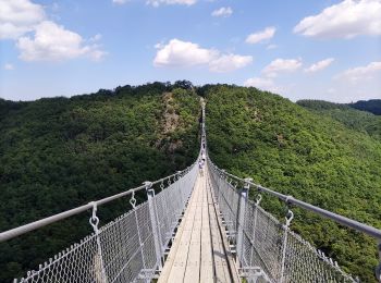
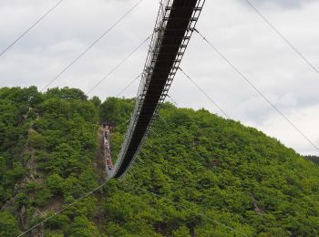
• Symbol: Stilisierte weiße Hängeseilbrücke auf blauem Untergrund
![Excursión A pie Dommershausen - Traumschleifen SaarHunsrück Baybachklamm - Photo](https://media.geolcdn.com/t/350/260/17f07876-73b9-4d12-bf70-d92688100f59.jpeg&format=jpg&maxdim=2)
![A pie A pie](https://static1.geolcdn.com/sitytour/trail-icons/100.png)
Km
A pie
![](/images/other/stat-length.png)
![](https://static1.geolcdn.com/siteimages/upload/files/1508320355ic_sort_den_pos_24dp.png)
![](https://static1.geolcdn.com/siteimages/upload/files/1508320355ic_sort_den_neg_24dp.png)
![](https://static1.geolcdn.com/siteimages/upload/files/16400158638029165_repeat_loop_refresh_sync_direction_icon.png)
• Symbol: Weißes S und H auf lila Grund. Weißer Text Traumschleifen Saar-Hunsrück
20 excursiones mostradas en 48
Aplicación GPS de excursión GRATIS